


BISAC NAT010000 Ecology
BISAC NAT045050 Ecosystems & Habitats / Coastal Regions & Shorelines
BISAC NAT025000 Ecosystems & Habitats / Oceans & Seas
BISAC NAT045030 Ecosystems & Habitats / Polar Regions
BISAC SCI081000 Earth Sciences / Hydrology
BISAC SCI092000 Global Warming & Climate Change
BISAC SCI020000 Life Sciences / Ecology
BISAC SCI039000 Life Sciences / Marine Biology
BISAC SOC053000 Regional Studies
BISAC TEC060000 Marine & Naval
To achieve a more robust interpretation of sediment conditions and transport, our study combines the two different interpretation techniques. A side-scan sonar survey was used as a basis for detail sedimentological investigation. Grain-size analyses of grab samples provided sediment transport direction and decoding of sonar data. The new detail lithological map of the underwater shore slope of the northern Sambian peninsula and the Russian part of the Curonian spit in 1:50 000 scale is created. For the first time, the stretched zone of very fine sands is outlined at depths of 25-30 m of the Curonian spit underwater slope. These sands are relicts, and their formation is connected with accumulative processes on the ancient shores of the Baltic Sea. Separate morpho-lithodynamic cells are distinguished on the submarine slope of the northern Sambian peninsula coast up to a depth of 20 m. The cape areas of the Sambian peninsula serve as cell boundaries where a divergence of sediment trend and seabed erosion are observed. The convergence of sediment transport directions is confined to the bight’s central parts. Fine and very fine-grained sand accumulation prevails here.
sediments distribution, sediments transport directions, coastal zone, Baltic Sea.
I. Introduction
Surface bottom sediments of the underwater shore slope of the northern coast of the Sambian peninsula and southern half of the Curonian spit have been studied quite extensively and mapped at different scales. However, the mapping has not been sufficient to perform a detailed investigation of such a highly dynamic sedimentation environment. Studies of the sediment dynamics and distributions are contradictory. There has been no consensus on the sediment transport directions and mechanisms of deposit formation until present [1; 2].
To achieve a more robust interpretation of sediment conditions and transport, we combined two different techniques. A side-scan sonar survey was used as a basis for detailed sedimentological investigation and sediment mapping. Grain-size analyses of grab samples provided sediment transport direction and decoding of the sonar data.
Morphologically, the coastline of the study area can be divided into two parts. The first is the abrasion northern Sambian peninsula coast, which has a latitudinal extent and is complicated by the Taran, Kupalnyj and Gvardejskiy capes. The second is the straightened accumulative coast of the Curionian spit, which extends from the southwest to the northeast. The peculiarity of the underwater shore slope is the domination of sediment material from the coastal abrasion and bottom erosion, but not from the river supply [3]. Westerly winds are dominant in the southeast Baltic Sea; coupled with a general surface water counter-clockwise circulation, these winds induce general sediment transport towards the north/northeast direction.
II. Material and methods
A lithological map (1:50 000) is created up to a depth of 30 m on the base of the bottom sediment type map [4]. The latest map was made by synthesizing bottom surface side-scan sonar surveys and grab sampling conducted by AOIORAN and VSEGEI during different projects in 2006 - 2014. However, this map had significant gaps in sea bottom coverage. New data obtained in 2014 – 2015 during the expeditions of AOIORAN cover these gaps and are used to create a new map. The scheme of the used material is presenting in Fig. 1.
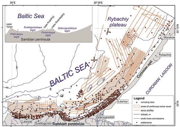

Fig. 1. Map of the study area with the locations of sampling sites and sonar profiles. the northern shore of the Sambian peninsula is shown in the inset.
Towed interferometric side-scan sonar Benthos C3D (200 kHz) was used for side scan sonar and swath bathymetry surveys. Data registration and processing were conducted using the hydrographic software Hypack 2014. Automatic classification of bottom sediments from sonar data was performed using the Hypack Geocoder software.
Surface bottom sediment samples were taken by Van Veen type grab and simple drag samplers. Grain-size distributions were determined by dry sieving analyses, with a set of sieves of 1/2φ intervals. The statistical parameters (mean size, Ma, sorting, So and skewness) of the grain-size data were calculated according to the graphic method of Folk & Ward [5] in the Gradistat software [6]. The sediment types were determined after the Folk classification [7].
We manually outlined bottom sediment type borders according to the sonar data, grain size analysis and results of the Geocoder automatic sediment classification. The map of bottom sediment types was created using ArcGIS software.
A sediment transport vector net was determined based on the McLaren sediment trend analysis method [8] with modifications of [9] and [10]. McLaren interprets grain size changes between interrelated sampling sites assuming that the sediment in the direction of transport should become either I) coarser, better sorted and more positively skewed (case C) or II) finer, and better sorted and more negatively skewed (case B). In our case of the open sea coastal deposits transported with sediment, coarsening is not suitable. For this reason, transport vectors were only obtained for “case B”. To achieve a regular net from irregular sampling data, grid creation in ArcGis was used [10]. It should be noted that the thickness of the transport vector arrows represents the significance of the result at that location, but not the intensity of the process. The areas of high vector strength are characterized by sharp changes of sediment types.
III. Results
The majority of the near-shore bottom surface is covered by sands (60.9 %) ranging from very coarse to very fine (Fig. 2). The sands occupy the flat sea bottom and fill the relief depressions.
Fine-grained sands are the most common sand deposits and cover 39.9 % of the sea bottom. They have a nearly uninterrupted extent along the coast of the Curonian spit up to depths of 5-10 m. The sands are well and moderately well sorted (average sorting is 0.8), with a mean size of 1.9 ϕ (0.25 mm). There is a second extensive zone of fine-grained sands at depths of more than 26-27 m on the underwater slope of the Curonian spit. This area is interrupted by the coarse grain sediments of the Rybachiy plateau.
Very fine-grained sands (12.3 % of the bottom surface) are well sorted (So=0.73), with a mean size of 2.8 ϕ (0.14 mm), reaching depths of 15-20 m in the central parts of the Philinskaya and Svetlogorskaya bights, up to a depth of 15 m in the Zelenogradskaya bight. In contrast, very fine-grained sands are not observed in the shallow zone along the Curonian spit.
Interestingly, the area of very fine-grained sands can be distinguished at depths of 20-30 m on the Curonian spit submarine shore slope to the south of the Rybachiy plateau. The sediments here have a smaller mean size (3.2 ϕ) and worse sorting (So=0.84) than the very fine-grained sands mentioned above.
Medium grained sands, covering 2.4 % of the investigated area, are represented by well sorted deposits (So=0.7), with a mean size of 1.8 ϕ (0.28 mm). They have a limited extent in the narrow zone shallower than 5 m in the Svetlogoraskaya and Pionerskaya bights. Additionally, there are two local fields of medium grained sands on the Sambian peninsula underwater shore slope at depths of 25-27 m.
Coarse and very coarse-grained sands together cover 4.5 % of the bottom surface and form on the periphery of moraine outcrops of the Rybachiy plateau and pre-quaternary deposit outcrops near the Taran cape. The coarse-grained sands have a mean diameter of 0.51 ϕ (0.7 mm) and sorting of 0.73, and the very coarse-grained sands are moderately well sorted (So=0.52), with a mean size of -0.04 ϕ (1.03 mm).
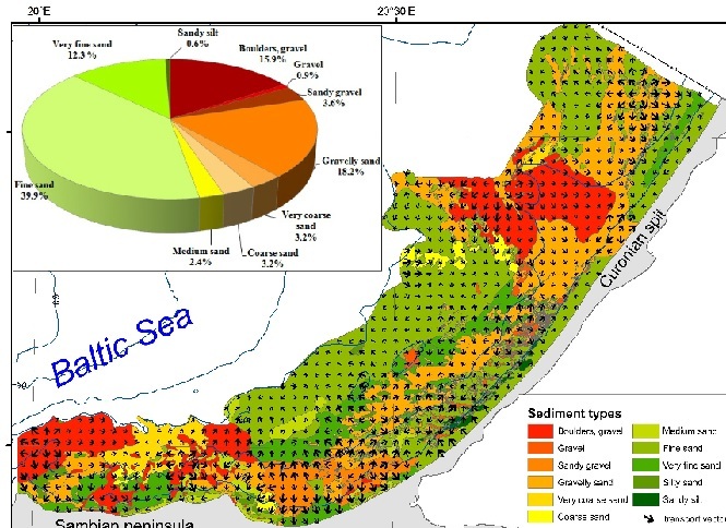

Fig. 2. Sea bottom surface sediment types and sediment transport vectors.
In the inset – percentages of the area covered with different sediment types.
Sandy silts (0.6 % of the sea bottom) are localized at depths of 5-17 m on the underwater shore slope of the southern part of the Curonian spit. They are represented by unique relict lagoon mud deposits, for which the extension, age and formation conditions were described in detail in the works of [11; 12].
Gravelly sands and sandy gravels cover 21.8 % of the study area. These are moderate or poorly sorted sediments (mean sorting is 1.9, with in the range of 0.4 to 3.4), with a mean diameter of 0.36 ϕ (0.8 mm). Gravelly sands and sandy gravel mark the glacial till outcrops near Zelenogradsk and Zelenogradskaya bay at depths of 5-20 m and near the Lesnoy settlement of the Curonian spit at depths of 20-25 m. These sediments are widespread on the Rybachiy plateau and locally adjoin to the shore. They also extend on the central part of the Philinskaya bight up to the 25 m isobath. The seafloor areas covered by gravelly sands and sandy gravels exhibit more complicated relief than the sandy areas.
Boulders, pebbles and pebble-gravely deposits are distributed on the 15.9 % of the bottom surface and mark the bedrock outcrops near the Taran cape and quaternary glacial till outcrops on the beam of the Kupalnjy and Gvardejskij capes and the Rybachiy plateau. At depths of less than 10 m, the seafloor is often covered by thin layers of fine and very fine-grained sands. The exception is the sea bottom area adjoining to the coast between the Philinskaya and Svetlogorskaya bights, where boulders join to the coastline. The sea bottom relief covered by boulder-pebbles and pebble-gravely deposits is very complicated and rugged.
III. Discussion
Sediment transport appears to be an important factor for the bottom surface sediment distribution. Traditionally, the sediment transport direction in the southeastern Baltic was determined by the concept of continuous Eastern-Baltic littoral drift from the Cape Taran to Cape Kolka near the entry to the Gulf of Riga [13]. However, a new model of relatively separate lithodynamic systems along the eastern Baltic coast was developed [14; 15]. Within the large-scale lithodynamic systems, smaller morpho-lithodymanic cells, separated by capes, were distinguished [16; 1].
Our results confirm the existence of separate morpho-lithodynamic cells on the Sambian peninsula northern underwater shore slope up to a depth of 20 m. Within these cells, divergence and convergence zones of sediment transport are formed. Divergent sediment transport vectors determine the cell boundaries located at beams of the Taran, Kupalnyj, Gverdejskiy and Lesnoe capes and in the vicinity of the Sambian peninsula. This finding is consistent with [14], which showed that according to model simulations and field observations, the zones of sediment transport divergence are formed near the capes areas. The coarse-grained sediments (boulders, pebbles, gravels) prevail in these zones and erosion processes supply an additional material on the submarine slope.
At depths of 20 - 30 m of the northern Sambian peninsula, the coastal transport vectors are directed east and northeast by the prevailing westerly winds.
Convergence sediment transport occurs at the centers of the coastal indentation of the Philinskaya, Svetlogorskaya and Pionerskaya bights, which is in agreement with [17]. Sediment transport of the dominant cross shore direction in these zones and accumulation of fine-grained sandy sediments occur up to depths of 20 m. According to [18], the permanent location of rip currents observed in the centers of the bays causes sediment erosion and seaward removal. However, our data show that transport vectors in the centers of the morpho-lithodymanic cells have an opposite direction toward the shore that contradicts the stable position of the rip currents. Their position is likely unstable and depends on wave parameters. According to [18; 16], the penetration of deposits between cells is limited and occurs only under storm conditions.
A different situation occurs in the Zelenogradskaya bight. Sediment accumulation is observed only in the narrow shallow zone up to depths of 5-10 m, where transport vectors are directed to the shore. There is a glacial till outcrop exposed to intense submarine erosion [2] that extends up to a depth of 20 m.
The particular feature of the sediment distribution on the sea bottom of the Curonian spit underwater slope is a sediment grain size alternation with increasing depth (Fig. 2). Fine-grained sands are distributed on both sides of the Rybachiy plateau at depths of 0-20 m. These sands are formed under recent accumulative processes and can refer to wave accretion deposits [2]. They are complicated by relict lagoon mud outcrops and coarse-grained sediments. Transport vectors are directed differently here. At depths of 20 m, fine-grained sands transition to gravelly sands, which are also characterized by different transport vectors. Seaward, at approximately 25 m, the zone of very fine-grained sands alternate with gravelly sands. Fine-grained sands with higher mean diameters cover the seafloor deeper than 28–30 m. The transport vectors display a common seaward direction.
The presented sediment alternation on the Curonian spit submarine slope disturbs the “normal” distribution of the bottom deposits with a seaward decreasing grain size [19]. There are different opinions about the very fine-grained sands, which are not typical on the underwater slope. Local zones of coarse silt (aleurite) were outlined on the bottom sediment map of the Gdansk basin by Emelyanov [20] at a depth of approximately 20 m. It should be noted that coarse silts in the classification used by [20] are considered to be very fine sands on the Wentworth scale. Emelyanov connected zones of very fine sands (coarse silts in the original classification) with recent sedimentation processes. However, Blazhchishin [21] interpreted very fine-grained sands at depths greater than 25 m as relict coastal deposits, formed on accumulative terraces associated with the early stages of the Baltic Sea.
The configuration of very fine-grained sands in the straightened form along the coast allows us to suppose that their deposition is connected with accumulative processes near ancient shores. Additionally, 30 m is the off-shore boundary of wave influence on the sea bottom [17]. Therefore, wave-driven sediment movement here is strictly limited. Consequently, very fine-grained sands in this area are relicts. Specification of the genesis and conditions of their formation needs a more detailed study.
Exclusively coarse-grained sediments (boulders, pebbles, gravel and sandy gravel) connected with glacial till outcrops prevail on the Rybachiy plateau. Here, at depths greater than 15 m, transport vectors have a general direction to the shore. These implausible results are likely caused by method particularity and a lack of data. Transport vectors change their direction to alongshore at shallower depths.
IV. Conclusions
A new detailed lithological map of the underwater shore slope of the northern Sambian peninsula and the Russian part of the Curonian spit at a scale of 1:50 000 is created. New features of sediment distribution are obtained. The sediment transport trends are determined according to the grain size parameters. A superposition of the sediment transport vectors on the sediment type map derived from side-scan sonar observations yields some interesting correlations.
Separate morpho-lithodynamic cells are distinguished on the submarine slope of the northern Sambian peninsula coast up to a depth of 20 m. The cape areas of the Sambian peninsula serve as cell boundaries where a divergence of sediment trends and seabed erosion are observed. Coarse-grained sediments are presented with boulders, gravels, sandy gravels and gravelly sands. The convergence of sediment transport directions is confined to the bight’s central parts. Fine and very fine-grained sand accumulation prevails here.
For the first time, the stretched zone of very fine sands is outlined at depths of 25-30 m of the Curonian spit underwater slope. These sands are relicts, and their formation is connected with accumulative processes on the ancient shores of the Baltic Sea during previous stages of its development.
V. Acknowledgment
The work was supported by Russian Science Foundation (grant No. 14-37-00047). Authors are grateful to colleagues from VSEGEI for providing part of grain-size and sonar data, also for A. Krek and E. Bukanova for sediment sampling and grain-size analysis.
1. A.N. Babakov, “Evolution of perspectives about long-shore sediment transport structure in the South-Eastern Baltic,” in Lithodynanic of ocean contact zone. Materials of international conference. Moscow, GEOS, 2009, pp. 56-58. [in Russian]
2. O.V. Petrov (Eds.), Atlas of geological and environmental geological maps of the Russian area of the Baltic Sea, St.-Petersburg, VSEGEI, 2010, 78 p. [in Russian]
3. E.M. Emelyanov, “Conclusion. Main features of sedimentogenes processis” in Sedimentation processes in the Gdansk basin (Baltic Sea), Emelyanov E.M., K. Vypyh (Edt.), Moscow: P.P. Shirshov Institute of oceanology AN SSSR, 1987, pp. 248-259 [in Russian]
4. V. Sivkov, E. Burnashov, V. Chechko, E. Dorokhova, D. Dorokhov, A. Krek, D. Ryabchuk, A. Sergeev, V. Zhamoida, “The bottom surface sediments mapping in the Russian part of the south-eastern Baltic Sea,” in Abstract Volume Baltic 2014 The 12 th Colloquium on Baltic sea Marine Geology September, Warnemunde: Leibniz Institute for Baltic Sea Research, 2014, pp. 47 - 47.
5. R.L. Folk, W.C. Ward, “Brazos River bar: a study in the significance of grain size parameters,” in J. Sediment. Petrol., 27, 1957, pp. 3-26.
6. S. Blott, K. Pye, “Gradistat: a grain size distribution and statistics package for the analysis of unconsolidated sediments” in Landforms, 2001, V. 26, pp. 1237-1248.
7. R.L. Folk, “The distinction between grain size and mineral composition in sedimentary-rock nomenclature,” Journal of Geology, 62, 1954, pp. 344-359.
8. P. McLaren, D. Bowles, “The effects of sediment transport on grain-size distributions,” J. Sediment. Petrol., 55, 1985, pp. 0457-0470.
9. S. Gao, M. Collins, “Net sediment transport patterns inferred from grain-size trends, based upon definition of “transport vectors,” Sed. Geol., 80, 1992, pp. 47-60.
10. M. Kairyte, R. Stevens, “Composite methodology for interpreting sediment transport pathways from spatial trends in grain size: A case study of the Lithuanian coast,” Sedimentology, V. 62, 2015, pp. 681-696.
11. A. Y. Sergeev, V. A. Zhamoida, D. V. Ryabchuk, I. V. Buynevich, V. V. Sivkov, D. V. Dorokhov, A. Bitinas, D. Pupienis, “Genesis, distribution and dynamics of lagoon marl extrusions along the Curonian Spit, southeast Baltic Coast,” Boreas, 2016.
12. V.A. Zhamoida, D.V. Ryabchuk, Y.P. Kropatchev, D. Kurennoy, V.L. Boldyrev, V.V. Sivkov, “Recent sedimentation processes in the coastal zone of the Curonian Spit (Kaliningrad region, Baltic Sea),” Z. dt. Ges. Geowiss., 2009, 160, pp. 143-157.
13. R. J. Knaps, “Sediment transport near the coasts of the Eastern Baltic,” in Development of sea shores under the conditions of oscillations of the Earth’s crust, Valgus, Tallinn, 1966, 21-29. [in Russian].
14. N.A. Bogdanov, “Forming and dynamic of marine placers near accumulative coast of South-Eastern Baltic Sea,” PhD dissertation, Moscow, MGU, 1987, 24 p. [in Russian].
15. A.N. Babakov, “Spatial - temporal currents structure and sediment dynamic in the coastal zone of the South-Eastern Baltic (Sambian peninsula and Curonian spit),” PhD dissertation, Kaliningrad, Geographical faculty, KGU, 2003, 273 p. [in Russian].
16. N.A. Aibulatov, L.A. Zhindarev, N.A. Piskareva, “Sediment transport in the coastal zone of South-Eastern Baltic” in Natural basement of environmental conservation, Moscow, 1987, pp. 99-116. [in Russian].
17. A.N. Babakov, “Sediment dynamic in the coastal zone,” in Oil and environment of Kaliningrad region, Kaliningrad: Terra Baltica, V. II. The Sea, 2012, pp. 276-291. [in Russian].
18. L.A. Zhindarev, A. Sh. Habidov, V.V. Scherbina, “Lithodymanic peculiarities of the tide-less sea and management model of the coastal zone,” in Sea coastal zone: morpho-lithodynamic and geoecology. Materals of XXI International coastal conference, KGU, Kaliningrad, 2004, pp. 34-38. [in Russian]
19. Uj. S. Dolotov, Dynamic environments of coastal sedimentation and relief formation, Moscow, Nauka, 1989, 268 p. [in Russian]
20. E.M. Emelyanov (Edt.) Geology of the Gdansk basin. Baltic Sea, Kaliningrad: Yantarnij skaz, 2002, p. 496.
21. A.I. Blazhchishin Littoral area in the Baltic Sea off the Sambian peninsula. In: Emelyanov E.M. (ed.). Geology of the Gdansk Basin, Baltic Sea. Yantarny Skaz, Kaliningrad, 2002, p. 375 - 380. [in Russian]