


BISAC NAT010000 Ecology
BISAC NAT045050 Ecosystems & Habitats / Coastal Regions & Shorelines
BISAC NAT025000 Ecosystems & Habitats / Oceans & Seas
BISAC NAT045030 Ecosystems & Habitats / Polar Regions
BISAC SCI081000 Earth Sciences / Hydrology
BISAC SCI092000 Global Warming & Climate Change
BISAC SCI020000 Life Sciences / Ecology
BISAC SCI039000 Life Sciences / Marine Biology
BISAC SOC053000 Regional Studies
BISAC TEC060000 Marine & Naval
The article represents a retrospective review of long time research of genesis and development of the Central beach in the City of Varna which makes possible a forecast of its further development. Both natural and anthropogenic impact on the beach evolution is taken into consideration. It is ascertained that construction of coastal protection structures at the northern part of the beach in 80’s resulted in cessation of natural beach area growth. The strengthen of a breakwater in the main port and illegal building also contributed to considerable coast recession and beach volume reducing. Because of this a recreational potential of the Central beach is gradually decreasing. New method named “cross-shore sediment bypassing” is suggested to reduce the negative trend.
Varna Bay, sandy beach evolution, anthropogenic intervention.
I. Introduction
The Central beach of Varna is located in the westernmost part of the Varna bay. (Fig. 1). It is bordered by Varna breakwater from the south, and by the bunker at “Malkoto casino” from the north. The Varna beach is a part of regional resort area and has a valuable recreational resource. It is wide enough and consists of sandy material of suitable grain size (medium-grained sand) and preferred mineral composition (quartz component exceeds 90%).
.jpg)
Fig. 1. The Varna Bay
The Varna beach received detailed investigation in 70-80s years [1, 2, 3, 4, 5, 6].
Based on the previous data obtained by the author and others, the current task is aimed at summarizing known results with particular attention to anthropogenic factor in the beach evolution during the second half of the previous century which makes possible a forecast of its further development.
The urbanization processes play the kea part in genesis and devеlopment of the beach having more than 110 years history. It can be clearly seen in the topographical map by captain Manganari, 1829 [7]. On the map, the coast behind the beach in its current borders is marked as a cliff. Many different factors contribute to the beach rising. Breakwater design has triggered the beach growth. The following natural conditions were favorable for this process: sediment transport in the coastal zone, configuration and exposition of the coastline, a character of the supporting province as a source of suitable sand material, relatively thick ravine system with temporary and constant water flows as “erosion maintenance” and also wind/wave conditions.
Lithodynamic conditions in the coastal zone.
The central beach of Varna is located in the westernmost part of the wide-open Varna bay. Outward the Varna bay, to the north-east and to the south from from its boundary capes, St. George and Galata, respectively, the coastline is almost straight. The lithodynamic activity in the bay is closely related to sediment transport in the adjacent coastal segments. Both abrasion and accumulation processes depend on of wave-induced longshore sediment fluxes. The scheme of sediment fluxes in the vicinity of Varna coast suggested [8] is characterized in the Table 1.
The capes St. George and Galata are zones of divergence and the westernmost part of Varna bay (Asparuh spit) is zone of convergence.
Table 1. Longshore sediment fluxes in the vicinity of Varna bay
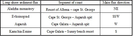
Under typical wave conditions, the long-shore currents in the Varna bay area are directed from capes towards the bay center. This is required premise for transporting and accumulating of sediment material in the convergence zone. In fact “unloading” of the Evksinograd and Asparuh fluxes in the westernmost part of the Varna bay during Holocene resulted in creation of sandy spit, which divides the bay separates the Varna lake from the sea.
Anthropogenic intervention in the coast
Originally building in the Varna bay area started very long ago, in ancient times. In that period so called “Asparuh shaft” forming an embankment along the sea coast was constructed. Its remains have been saved in the sea park of the Asparuhovo district and “Ostrova”. The shaft is assumed to be constructed by Bulgarians during the VIII century to protect the low coast against the byzantine landings [9, 10]. It was possibly used as a road artery in the low, marshy areas of the Asparuh sandy spit. The third version is the shaft prevented stormy waves. It should be noticed that the shaft was designed quite well as we can observe it until now. Probably it was erected higher than maximal distance of wave run-up reach. This reason is not always taken into account up today.
Excluding the wooden scaffolding (low trestles) for unloading of sailing ships, until the start of XX century, nothing else has been built in the area. Only in the beginning of XX century Varna’s commercial port has been built. The high professionalism of its design makes an impression, even today. The most important is a skillful positioning of its fencing installations. The siltation of the fairway and port’s aquatory aren’t stated.
The fencing structures are manifested as the artificial borders for above mentioned sediment fluxes. The built Varna main jetty, better known as the Varna breakwater, is insuperable obstacle for sand material carried by the Evksinograd sediment flux. The amount of incoming sediments is about 25.000-30.000 m3/year [11, 2].
On the one hand the sand accumulated here formed along-beach strip, which in time became a valuable recreational resource of the city (Fig. 2.). On the other hand, the beach extension over 1200 m along the coast guarantees complete dissipation of incoming waves energy. So the beach plays a buffer role protecting the strongly destructible coast against the sea wave impact.
In 30th the construction of port “Evksinograd” had been finished. The environmental conditions are favorable for operating of commercial port in spite of appearing tombolo effect and periodical need of harborage dredging.
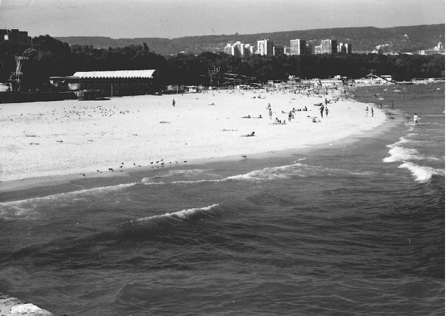
Fig. 2. Varna Central Beach (the author’s photo)
In the end of 50s an unsuccessful attempt for coastal protection of “Pochivka” district was made. The groins were built here to create protective beach strips in front of the strongly abrasive coast. However these structures failed to fulfil their part because of insufficient length. Another reason in the same sense is the “incomplete profile” along the length of the groins, which made them floodable even from minor waves.
In the end of 70s and in 80s construction of coastal protective structures intensified strongly, especially in the northern part of the Central Varna beach. At the same time the groin at cape “St. Dimitar” (Evksinograd) was built. “T-shape” groins were constructed at the complex “Riviera” and in the yacht complex at “Sunny day” resort. And shortly thereafter Г-shape groin was built in the northern part of the “Golden sands” resort. Consequentially the 101, 102, 102B, 103 and 109 groins were built – all in the “Ribarski most” – “Trakata” section. Approximately in the same period the other groins in the “Evksinograd” area were constructed.
- The coast-protecting dam of “Malkoto casino” near the groin 103 represents an example of large-scale construction. Considered as an element of the system including the basic coastal structures (the groins) it actually turns out as substantially passive structure. During the designing of groins, the natural sand-trapping effect was expected. Later it turns out that the capacity of Evksinograd sediment flux is not as strong as intended, and so the space between the groins could not be filled by natural process. Hence it was decided to use the artificial beach nourishment implying the import of sandy material.
Although off-topic, it is not meaningless to express opinion on the benefit from further building of dam near the “Evksinograd” residence. The reasons are the following:
- stopping of the direct abrasion effect on the coast subject to landslide processes;
- creation of dry-land territory on the sea bed (between the dam and the steep, nearly vertical coast), filled 2-3 m above the sea level. Such a territory could satisfy the needs of different kind.
For the beach nourishment the author’s method of “cross-shore sediment bypassing” should be recommended [12]. This implies transporting of sand material accumulated earlier on the sea bed outside the coastal zone. All needed requirements for this method use are fulfilled (technological equipment and available sand source located in adjacent bed area outside 10 m isobath). Using this method wide enough sandy beach can be formed between the groins 101 and 109. It is proved by successful approbation of the method in the coastal segment between the groins 102 and 102-B in 1990.
There are different viewpoints among the specialists on coast-protecting structures.
Critics of the previous activity give the following arguments:
- the constructions damage the natural coastal landscape;
- water circulation worsens between groins;
- between-groins pockets work as traps for all kinds of pollution;
- change of bottom substrate properties (sanding of otherwise rocky bottom) affect composition and structure of the bottom biocenosis.
Supporters stand on opposite grounds with the following reasons:
- new territories are captured and the capacity of the sandy beach recreational resources raises;
- filling of between-groin spaces with sandy material decreases direct impact of the sea on native coast and interrupts the coast degradation processes; water circulation is improved due to both alongshore mixing and water exchange with the open part of the bay;
- at least a part of basin is protected by adjacent groin from waves, which is favorable for safe water consumption;
- if multifunctional approach is applied at designing phase the decision can be foreseen for use of the groins as seasonal piers for different attractional purposes;
- construction of protective dam and groins significantly improves the contact of the man with the sea. These structures can be used for recreation, as well as for fishing.
It is obvious, that every future decision should be taken after a long, thoughtful, unbiased and comprehensively justified techno-economical reasoning, in full harmony with the environment.
During the last decade of the previous century the project “Strengthening Varna breakwater” is implemented. The breakwater protective blocks are strengthened and the bed surface at the outer side of breakwater is fixed to stabilize the structure and improve the wave damping. In frameworks of the project an underwater defensive berm of total lenght 520 m is erected in a coastal segment between the bend of coast and marine passenger terminal. The stone blocks of height 3.0, 4.5, 6.5 m and widths 30.0, 36.5, 47.0 m weighting about 500-1500 kg are used. In the vicinity of the marine terminal 300 tetrapods (of bevel 1:2.5 and weighting each 10 ton) are mounted along 220 m coast. Completely correct is the finding in the report for EEI (evaluation of environmental impact) on the project “Strengthening Varna breakwater”, that the grade for the expected impact on the installation itself, as well as on the morphological elements of the bay coast, are needed in careful research (using the coastal modelling), which is defined by the class of the installation (in this case – Class I). Unfortunately, in the final wording of the report for EEI, this certainty is lacking and the project got the green light. Essential omission in the part “Plan for surveillance and control”, in the same report, is the lack of a program for partial lithodynamic monitoring, since the suggested technical solution (underwater berm) substantially amends the so called roughness of the bottom, which could significantly affect the sediment transport and as a consequence – the configuration of the bottom topography (especially close to the breakwater), as well as the contour of sandy beach in adjacent coastal segment.
Coastline dynamic
Before erection of the main structure of Varna commercial port i.e. the breakwater, an evolution of the NNE-ward coastline was controlled by abrasion processes rated as 0.20 m/year even for a later period [13]. The surface of coastal slope is practically devoid of sand deposits, which is evidence of passive character of the bed changes under wave impact. On the map of 1829 made by above mentioned captain Manganari the coast is marked as a cliff, as well as it appears in the picture of 1890. An erection of the port breakwater in the beginning of the previous century, created conditions for filling the so-called incoming angle by accretion of sand carried by Evksinograd sediment flux [8]. As a result a sandy beach has arisen and reached a length of about 1200 m in a very short time period. After 61 years of the port breakwater construction, the beach reached 89 m in width [4], which corresponds to average growth rate of 1.5 m/year. In the vicinity of already non-existent bridge in front of the “Aquarium” the rate of beach propagation is 1.8 m/year and in front of the fisherman bridge it is 0.91 m/y. In the northeast direction the sand strip narrows and gradually vanishes.
On a basis of monthly observations over 20-years period of 1948-1968 was concluded that the beach growth continued but with lower rate [1]. The beach growth reached about 28 m (1.4 m/y) near the breakwater, 20 m (1.0 m/y) at the bridge in front of “Aquarium”, and 14 m (0.7 m/y) at the Central Bridge. During the 70s the beach continued enlarging, but rate became noticeably lower, 0.58 m/y [5].
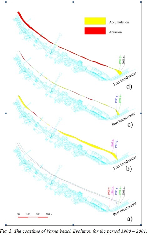
Changes in the coastline position during the second half of the previous century are represented in Fig. 3а. The data were taken from the maps of 1961 and 1983 issued by Geodesy and Cartography Department (1:5000), on the coastline study of the Institute of Oceanology BAS in 1991 and on the cadaster of Varna, 2001. Changes in the beach area and the coastline displacement are reflected in the Тable 2.
Table 2. Evolution of sandy beach NNE from Varna bay for the period 1961-2001
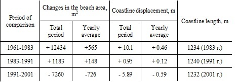
Note: The sign (+) marks the beach widening and the coastline advance towards the sea but (-) means the coastline retreat.
Construction of the groin to NE of the beach resulted in partial interruption of the natural way of the coastline advance continued for more than 80 previous years. The general trend of coastal development (seen from Fig. 3b) still remains. The observed beach increase in the west half of the coast is a result of sand accumulation (before the groin 101 construcrion). For the next about 20 years’ period, the average rate of the beach growth was 0.46 m/y along its entire length. The observed in the most NE part of the beach could be explained as a result of the “wave shadow“ due to the groin 101 construction in the end of the comparative period. It should be noted that during the groin construction an intensive material transport from the beach to its central part was observed under the extreme storm conditions. The other part of the coastline is considered as a zone of sediment transit without changes in coastline shape.
The next period of comparison (1983-1991) demonstrates conservation of the coastline position. Sand accumulation in immediate vicinity of the breakwater can be related to maintenance works started prior and continued during the studied period (Fig. 3c.).
The coastline changes after 1991 were extraordinary (Fig. 3d). Relatively light and harmless constructions were performed in the beginning of the period of the beach growth and adaptation. With time they were replaced with heavy, dense and massive concrete ones especially in the northern beach area.
In the middle of the project “Strengthening Varna breakwater” [14] processing, the overall reduction of the beach area is started. The increased bottom“roughness” and earlier wave breaking over the underwater berm constructed along the breakwater consisted preconditions for permanent accretion of sand material. Figuratively speaking this zone appears as a trap for sand sediment. Due to lack of sediment sources and interruption of the Evksinograd sediment flux by the groins, the coastline began its moving towards the land and the beach area began to decrease. On average, during the observed period the coastline retreated by 6 m with the mean rate 0.59 m/y. The beach growth in this period was noted only near the very breakwater (about 35 m). Here the substantial shallowing of the aquatory is observed. The shrinking of the sandy area is very negative looking from a recreational standpoint, because the recreational potential of the area get lower. The increase in the beach area in a minor beach segment near the breakwater does not contribute visibly to the recreational capacity. From this point, even a positive balanceshouldn’t be considered as a sufficient compensation of the negative trend. The shift of the coastline was most active during and right after the execution of the construction. In the future deceleration of this process should be expected, but not the total absence of the bed deformations in the beach. The above considerations give the reasons for organizing and fulfilment the local lithodynamic monitoring of the beach area. Adequate compensational technical solutions could be elaborated only on the base of sufficient and representative information on the beach evolution.
1. Rojdestvenski Al. V. 1972. The beaches along our Black sea. Nature and knowledge magazine, (S.)
2. Dachev, V. 1973. Cyclical alteration of the beach profile at the Central beach of Varna. CNID at DSO “Water transport” Varna.
3. Popov, Vl., P. Sokolova. 1974. Lithodynamic in the coastal part of the shelf between the Varna breakwater and c. Oficerski plaj. Izv. (?) to Geographical institute (S.) t.XVI.
4. Popov, Vl., K. Mishev. 1974. Geomorphology of the Bulgarian Black sea shore and shelf, (S.)
5. Dachev, V., Hr. Nikolov. 1977. Integral alteration of the coastal line at the accumulation section between cape Cherni and the Albena resort. Oceanology (S.), r. 2.)
6. Nikolov, Hr., V. Trifonov, G, Stoev. 1985. Development of the beach streaks along the Bulgarian Black sea shore. Oceanology (S.)
7. Mangari, E. 1829. М а н г а н а р и Е. 1829. Varna’s bay in ancient Odessos.
8. Dachev, V., J. Cherneva. 1979. Evaluation of the longshore moving of the sediments at the Bulgarian Black sea coast between c. Sivriburun and the Burgas bay. (S.), 4.
9. Shkorpil K. 1932. Archeological notes of the Black sea coast. Varna
10. Bojkov, L. 1936. Notes for Lake Varna. Published to BGD(S.), book IV.
11. Minkov, V. 1972. Port construction, (S.)
12. Dachev, V. 1990. Cross bypass of the sea sands in the Varna bay. Fund IO, BAN, Varna.
13. Pejchev V. 1998. The abrasion process of the Bulgarian Black sea shore. Sb(?) “Coast strengthening and long term stabilizing of the slopes of the Black sea shore. (S.)
14. Report for OVOS of project “Strengthening Varna breakwater”. 1996, Fund of MOSV, (S.)