


BISAC NAT010000 Ecology
BISAC NAT045050 Ecosystems & Habitats / Coastal Regions & Shorelines
BISAC NAT025000 Ecosystems & Habitats / Oceans & Seas
BISAC NAT045030 Ecosystems & Habitats / Polar Regions
BISAC SCI081000 Earth Sciences / Hydrology
BISAC SCI092000 Global Warming & Climate Change
BISAC SCI020000 Life Sciences / Ecology
BISAC SCI039000 Life Sciences / Marine Biology
BISAC SOC053000 Regional Studies
BISAC TEC060000 Marine & Naval
Currently, there is no single view of the Holocene global sea level kinematics. At the same time, the question of a possibility of it exceeding the current sea level by several meters is be-ing debated. The accumulative coasts of nearly tide-free seas, in areas where the vertical di-rection of coastal movement remained unchanged are the most convenient objects for study-ing this major paleogeographic issue. Effects of the sea level fluctuations are revealed in the resulting geomorphological structure and in the nature of sediment areas of the coastal zone developing in an accumulative mode. If the Holocene sea level exceeds its modern marks, then ladders of accumulative terraces would have formed over different parts of the coast. The heights of the terrace ladders would correspond to the amplitudes of these exceedances. The lower sediment levels should reflect the transgressive character of their formation in the structure of geological section, while the higher levels would reflect the regressions. The coast of the Thatcher Peninsula, located in the Bay of Cumberland microcontinent of the South Georgia (Antarctic) was the focus of our research. It was established that the Holo-cene sea level in the region reached its current state no later than about one thousand years ago and did not exceed it, being subjected to only minor fluctuations of the synoptic scale. The accumulative terraces are located in fragments. The differences in their absolute eleva-tions are related to their correspondence to different tectonic units experiencing differenti-ated uplift.
World Ocean, sea level rise, Holocene, sea coasts
I. INTRODUCTION
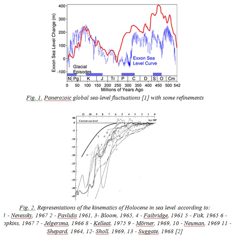
Information about the state of global sea level is one of the most important in the study process of the Earth's history. To date, in particular, it found that since the Tertiary period, he falls, experiencing fluctuations under the influence of various factors - climatic, tectonic, etc. (Fig 1). The most studied kinematics of the sea level in the Late Quaternary. However, researchers have not come to a complete agreement, even with regard to the latter - the Holocene, stage (Fig. 2). Significant progress in this discussion include recognition of the low position of the sea level at the beginning of the global postglacial transgression (however, estimates of sea level provisions differ), as well as the consent of the researchers in the impossibility of constructing a unified graphical model (curve) of this transgression. Among the major differences are, for example, evaluations of the kinematics of the sea level after the boreal period the Holocene. In this issue clearly delineated three concepts (Fig. 2). 1. The sea level increased, asymptotically approaching the modern, and perhaps, felt vibrations of varying duration and low amplitude (within the accuracy of measurement - a few tens of centimeters). 2. About 6 kilo years ago sea level has become higher than the present for a few meters and then, after some hesitation, occurred noticeable (up to a few meters) undulation between 4.5-2 kilo years ago. Then, the sea level dropped to modern heights and experienced only minor fluctuations. 3. The sea level reached the current situation in the Atlantic period, and subsequently did not significantly changed. There are also other positions of individual researchers, including allowing sea level fluctuations with an amplitude of a few meters the entire second half of the Holocene. Most often controversial question becomes: reflect the forms of coastlines of the Holocene higher position of the sea level or tectonic uplift coast of height close to modern.
Allocated problem is not purely scientific. Its decision is due to the forecast of development of the coastal zone and shelf. If the level of the World ocean in the Holocene is constantly grew, slowing down to a relative stabilization, of the modern form of the coastal zone must be regarded as mature (stable). They have adapted to the dynamic mode of the respective marine areas. If sea levels fluctuate with an amplitude of several meters (or even up to a few tens of meters), it must be supposed that the current relief of the coastal zone is not different relative stability. In this case, the greatest negative consequences are associated with sea level rise.
Thus, the economic development of shore areas depends on understanding the trends of changes land and sea interface zone. A variety of existing kinematics models of sea level in the form of graphs (curves) can be explained by the fact that not always take into account such important factors as the regional and local tectonic setting, often an insufficient number of dating; the subjectivity of the ideas and concepts, and sometimes biased theories and concepts of researchers.
The consequences of sea level fluctuations expressed in the structure of the relief and sediments of the coastal zone. Especially convenient objects for studying this problem are accumulative coasts of nearly tide-free seas, in areas where direction of the vertical movement of the coast were constant and the age of the coastal sediments it can be set. It is now known that the geological deposits of the coastal zone, on accumulative developing scenario, differ mainly in their granulometric compositioin. If the sea level during the Holocene exceeded its current, then the accumulative section of the coastal deposits of this age should be composed of lower - transgressive, and in the upper - regressive sediment units. If this raise was not, then deposits will be presented regressive sediment units.
Thus, a reliable sign of a higher than modern sea-level positions, are accumulative terraces by coastal processes, and located higher the modern coastal zone. The structure of the deposit-units of these terraces must contain transgressive-regressive of littoral facies, reflecting the sea level change.
In addition, such fluctuations were to create on different coasts of stairs accumulative terraces with a height corresponding to the amplitudes of the prospective elevation of sea level. At the same time on the coast of elevation the present height of the these terraces should be above their initial position (that is greater, than the expected positive amplitude Holocene transgression) because of the subsequent neotectonic movements.
On the coasts of the positive or negative structural-tectonic deformations can be observed forms of the coastal relief, developing, respectively, abrasion or accumulative scenario. Their formation started at the level of the sea close to the current and possibly only slightly above its. For positive neotectonic structures of the most characteristic elements of the coastal relief, depending on the initial slopes of the coastal land, its lithology and the presence of loose sediments are not active, but well-defined cliffs, abrasion recesses, progradation accumulative terraces, dying lagoons and other forms combined with regressive structure relevant these forms of littoral sediments.
Determine whether the sea level was at a particular coast above the present can only be based on an integrated approach involving the results of the study of geology-geomorphological, tectonic and climatic characteristics of a particular region, it paleogeography, the forms and the role of biogenic factors, the specificity of the effect of marine waters on the formation of relief and sediments of the coastal zone.
II. RESUTLTS AND DISCUSSION
The coastal zone of microcontinents Madagascar and South Georgia
Consider the results of the coasts of research that exist in different geological and geographical conditions, but is characterized by stability plan neotectonic structure and consistency in the direction and activities of the Holocene vertical tectonic movements. As an example, first consider the areas of coasts of microcontinents Madagascar and South Georgia. These areas with differences in geological structure, geographical location and the development of history, a tendency to a general raising of the neotectonic stage.
In Madagascar, we explored the coast lowlands fringing the south-east and south-west island for hundreds of kilometers. For example Morondava region (Fig. 3), we see that the accumulative coast is formed regressive sand sediments with the exception of the delta area of the river of the same name. At the mouth of the river alluvial deposits overlap thin transgressive sediments, which is associated with a corresponding neotectonic lowering of fault zone.
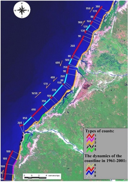
Fig. 3. Types and dynamics of contemporary coastal processes on the accumulative shores of Morondava are
Legend: shores types: 1 - erosion, actively collapsing, developed in the sandy sediments of sea terraces; 2 - accumulative-erosion developed in the sandy sediments of sea terraces. Accumulative: 3 - lagoon, 4 - lagoons, armored of coral platforms, 5 – delta; 6 - border coral platform. The dynamics of the coastline in 1961-2001 yy. (the figures - the maximum displacement of coastline at the site, m): 7 - displacement of remote accumulative forms along the coast, 8 - retreat, 9 - advancing forward; 10 - borders of the sections. The black arrows show the ledge that separates seaside sea and alluvial-sea terraces of alluvial plain. The white arrow shows the site of flooding of the delta r. Morondava
On the coast of microcontinent is widely distributed accumulative sea terrace height of 1.5-4.5 m, created adjoined to each other beach ridges. Age terraces defined in the 3740 ± 90 14C years, and its formation is linked to higher sea level during this period [3]. There are also other terraces of the same origin, including those located at a higher elevation. So, the age of the lower units of the terrace with a height of 12-13 meters in the south-eastern coast of the island is estimated at 2410 and 6455 cal. yr BP [4]. Such a high position terraces logically explain the neotectonic elevation coast. Lush forests of coast of region, which is preserved after a brief rise in sea level in the storms and tsunamis, successfully cope with the negative effects, including getting rid of penetrating salts and contained in sea water minerals. On the coast of elevation, with regressive type of formation of sediment, the upper units of the geological section of the territory which came out from under the sea level does not contain geochemical evidence of the presence of sea water. With eustatic transgression vegetation flooded coast for a long time, including after the death, it is in subaqueous conditions. Then the fossil fragments of vegetation should be preserved in large numbers in the geological section of the terraces. They should have increased salinity, and contain an abnormal microelements quantity characteristic for the marine environment, particularly strontium. But the geochemical analysis of fossil remains of trees and other coastal vegetation these accumulative terraces, including relations Sr/Ca, does not allow to conclude that the long-term impact on them of the marine environment [4].
North Coast microcontinent South Georgia, characterized by active manifestations neotectonics bloc. Here alternate abrasion and accumulative coast. For the first characteristic inactive cliffs and narrow (from the first meters to 15-20 m) erosion terraces in front of them with the absolute height of 1 ÷ 2 m. Sometimes a terraces covered with a thin (a few tens of centimeters) layer of debris sediments. At a height of 2 ÷ 4 m are also a abrasion recesses with of diameter up to 2 m (Fig. 4). On the second formed accumulative terrace widths of up to a few tens of meters and in height of terrace joint no more than 2.5 m. In the geological section lower units of terraces stacked of rudaceous varying degrees of roundness littoral sediments. The upper unit is represented by peat bogs with poorly decomposed plant residues. Peat power reaches a few tens of centimeters at the terraces joints and is tapers to zero off towards the sea. The surface of the terraces is covered with meadow vegetation, which is towards the sea from a continuous sheet goes into clumps, replaced by separate instances. As an example, the terrace on the south east coast of the peninsula Thatcher, located in Cumberland Bay (Fig.5, 6). The age of lower units of peat is according to radiocarbon dating 860-900 14С years [5]. Higher forms of coastal terraces in the area are not greeted by, although there are all conditions for their formation: gently sloping coastal land, composed of poorly consolidated subaerial, mainly glacial and slope deposits. Published in the literature [6], the description of the higher accumulative terraces microcontinent in other areas, such as in the area of the Cape of King Edward, also shows a regressive nature their of deposits sections. Current height accumulative terraces microcontinent more logical to link not glacioeustasy (as is done by some researchers), and uplift corresponding to these terraces of tectonic blocks. First, the island's mountain-valley glaciers flowing down the slopes of the mountains directly into the sea, could not have a greater thickness in the range narrow mountain foothills. Secondly, glacio isostatic compensation and alignment of isostasy (if we assume, as it occurs in the literature, subsidence of the crust under the ice load at 1/3 or 2/7 of its thickness), occurs geologically fast - a few hundred - a thousand years. Even in those areas where the glaciers covering hundreds of kilometers in diameter and have a lot of thickness [7, 8]. There is also an extreme point of view, that the phenomenon of post-glacial rebound in general not significant, and this concept needs to be revised [9, 10]. It is known that a decrease in the area of continental glaciation of the world sea level rises. Studies of the dynamics of the Larsen ice shelf on the Antarctic Peninsula have shown that the current size of the glaciers here is minimal during the Holocene epoch [11]. The dynamics of glaciers in Greenland shows other trends [12]. Thus, the question of sea level fluctuations and their causes requires further research.
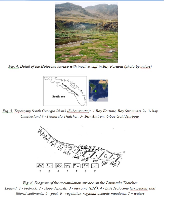
The structure of relief and sedimentation of coastal areas of the two microcontinents discussed above indicates a regressive type of formation of coastal lowlands. It can serve as proof that the sea level during the Holocene did not exceed its current height. Differences of heights terraces of two microcontinents, can be considered a consequence of the uneven of uplift of tectonic blocks. Such raising of geostructural major elements of the earth's crust continues to Neogene. Movements Holocene phase of tertiary inherit direction in the respective regions. Thus, the results of the study the accumulation terrace South Georgia microcontinent indicated that raising the rate of the study area for the in recent 900 years is about 2.8 mm/yr.
Accumulative coast of continents (some examples)
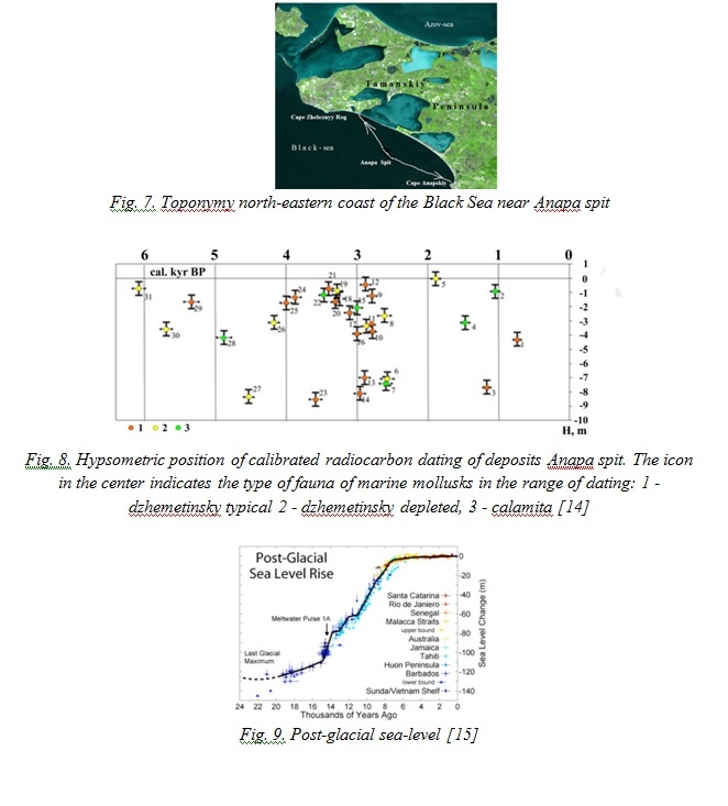
Arrangement and development of the accumulative coasts of the structures of continents by the example of the north-eastern of the Black Sea and the south-eastern part of the Baltic Sea. Under the conditions of low-lying coast of the Black Sea in the second half of the Holocene formed a sand spit Anapa (Fig. 7). Genetically she is a regressive formation of a combination of accumulation of bodies in the form of spits and beach ridges, lying on the alluvial deposits. Formation of the spit began seaward of the present position in dzhemetinskoe during the Holocene, about 5 thousands of years ago. During this period, the level of the Black Sea approached during postglacial eustatic transgression to the current height (perhaps about 1 m below). The main stream sediment along the coast sent to south - from Cape Iron Horn to the Cape of Anapa (Fig 7). Counter flow is less important in terms of volume and length. Making of spit close to the modern form was held in nimfetki epoch, that is, in the last 2.5 thousands of years ago. During this period, the sea level was at a height close to the modern and has been relatively stable, undergoing only a slight (within a few tens of centimeters) fluctuations synoptic nature. It is noteworthy that at the moment the seam roof of dzhemetinskih beach deposits exceed the current level of the sea at 1.5-2.5 m and fauna of mollusks in modern sediments spit (Fig. 8) shows that in the second half of the Holocene sea level was not higher than the present [13, 14]. This is confirmed by data on other coasts of the world's oceans (Fig. 9). Shown in Fig. 7 lagoons of artificial origin and is now reduced both the area and depth of water. These as well as other geological and geomorphological materials suggest that the region of Anapa Spit differential tectonic uplift. Thus, the height of the position of the roof dzhemetinskih unit may indicate of the rise at a rate of 0.5 mm/yr. Faster rise separating the lagoons outlier, then Anapa Cape and Cape Iron Horn (Fig. 7).
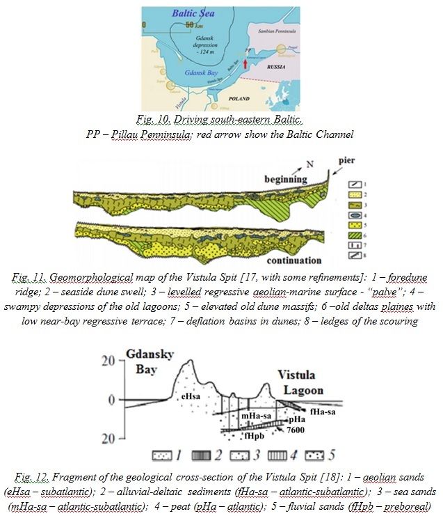
In the south-eastern edge of the Baltic Sea in the historical time of the Holocene formed a sandy Vistula spit. The basis spit developed during the second half of the Holocene transgression as subsea beach ridges, that gradually shifting towards the land by virtue of the specificity of coastal hydrodynamics. Under certain conditions, the largest beach ridges were converted into bars. Even in the XII century there were several island bars. Due to the construction at the beginning of XVI century in the northern part of the navigable channel spit it became known as the Vistula Spit. After administration, it was divided between Poland and Russia, the Polish part of the Vistula Spit is called, and the Russian - Baltic (Fig.10). Spit largely consists of rebuilt of wind sandy coastal accumulative forms several generations. In its structure there are also outliers glacial and alluvial plains, preserved from erosion as sea waves, and the waves of the lagoon [16, 17, 18] (Fig.11, 12). Investigations revealed that the formation of the Vistula Spit happens in a moderately differentiated block structure of the eastern slope of the Gdansk depression, created by faults directions northwest. Most raised block is located north of the village Borovoye to 54˚23' north. This block corresponds to the widest part of the spit and the highest level of its relief in excess of 40 m. Within blocks, that rising less active, spit narrowed and its height is reduced. In accordance with the above it can be assumed that the structure of the spit reflects the regressive type of its formation. The presence and relief of littoral genesis forms is above the sea level due to tectonic uplift, rather than high-Holocene transgression. It can be assumed that the current rate of uplift in the spit area of roughly comparable (at least, no less) at a rate of slight increase of the level of the Baltic Sea, which caused by the current, a geologically short-lived climatic cycle of the planet [19]. This may explain the relatively stable state coast of the spit, since the depth of the underwater coastal slope also remained largely unchanged, allowing wind-wave factor to mobilize available yet sufficient bottom sediments and move it to the coast.
III. CONCLUSIONS
It was found that the Holocene sea level in the two microcontinents has reached the current state not later than 1 thousand years ago, and not exceed it, subjected to only minor fluctuations in the synoptic scale. Differences of heights terraces of microcontinents, can be considered a consequence of the uneven of uplift of tectonic blocks. A similar situation is often observed as the coasts within the tectonic structures in the continents. The question of sea level fluctuations and their causes requires further research.
IV. ACKNOWLEDGMENT
The work was supported by the State order (0149-2014-0035 theme, the theme of "The Evolution of the natural environment, the dynamics of relief and geomorphological safety of nature", RFBR project № 16-05-00364.
1. Hallam, A. Phanerozoic sea-level changes. New York, Columbia University Press, 1992. 266 p.
2. Dunaev N. N. Kolichestvennyj analiz vertikal'nyh tektonicheskih dvizhenij na shel'fe Kuby // Okeanologija, 1977. T. XVII, V. 6. P. 1050-1054.
3. Battistini R. L'extreme Sud de Madagascar, e'tude geomorphologiue. Paris: Editions Cujas, 1964. 636 pp.
4. Malika V-S., Katherine J. W., Lindsey G. Threshold response of Madagascar’s littoral forest to sea-level rise // Global Ecology and Biogeography, 2009, (18). P. 98-110.
5. Dunaev N. N., Sulerzhickij L. D. Ostrov Juzhnaja Georgija kak blagoprijatnyj poligon dlja izuchenija golocenovyh kolebanij urovnja morja // Geomorfologicheskie i paleogeograficheskie issledovanija poljarnyh regionov. Sbornik materialov. SPb, SPbGU, 2012. C. 114-117 (in Russian).
6. Chalmers M., Clapperton M.A. Geomorphology of the Stromness Bay area, South Georgia // British Antarctic survey scientific reports, 1971. № 70. 25 p.
7. Artjushkov E. V. Chetvertichnye oledenenija i transgressii v Zapadnoj Sibiri // Izvestija AN SSSR, ser. geol., 1967, № 7. S. 98-114 (in Russian).
8. Artjushkov E. V. Geodinamika. M.: Nauka, 1979. 328 s. (in Russian).
9. Kuzin I. L. Mify i realii uchenija o materikovyh oledenenijah. SPb.: Izd-vo SZNII «Nasledie», 2013. 178 s. (in Russian).
10. Chuvardinskij V. G. Bylo li materikovoe oledenenie? Mify i real'nost'. Saarbrjukken, Germanija: Lambert Academic Publishing. 2004. 284 c. (in Russian).
11. Domack E., Duran D., Leventer A., Ishman S., Doane S., McCallum S. et al. Stability of the Larsen ice shelf on the Antarctic Peninsula during the Holocene epoch // Nature. 436, 2005. P. 681-685.
12. Huybrechts P. Sea-level changes at the LGM fromice-dynamic reconstructions of the Greenland and Antarctic ice sheets during the glacial cycles // Quaternary Science Reviews. 21 (2002). P. 203-231.
13. Izmajlov Ja.A. Jevoljucionnaja geografija poberezhij Azovskogo i Chernogo morej. Kniga 1. Anapskaja peresyp'. Sochi: Lazarevskaja poligrafija 2005. 174 s. (in Russian).
14. Izmajlov Ja.A., Arslanov H.A., Maksimov F.E. Radiouglerodnaja hronologija formirovanija golocenovyh morskih otlozhenij Anapskoj peresypi (chernomor-skoe poberezh'e). Fundamental'nye problemy kvartera: Materialy IX Vserossij-sko soveshhanija po izucheniju chetvertichnogo perioda. g. Irkutsk, 15-20 sentjabrja 2015. Irkutsk: Izdatel'stvo Instituta geografii im. V. B. Sochavy SO RAN, 2015. T. 2. S. 188-190. (in Russian).
15. Rhode R. A. 2007 postglacial sea-level / http://www.oceans.cat/cursos/files/. 20.03.2016.
16. Badjukova E.N., Zhindarev L.A., Luk'janova S.A. and Solov'eva G.D. Osobennosti geologo-geomorfologicheskogo stroenija Baltijskoj (Vislinskoj) kosy // Uchenie o razvitii morskih beregov: vekovye tradicii i idei sovremennosti : mater. konf. SPB., 2010. S. 170-172. (in Russian).
17. Badjukova E.N., Zhindarev L.A., Luk'janova S.A. and Solov'eva G.D. The geologic-geomorphological structure of the Baltic (Vistula) Spit (Geologo-geomorfologicheskoe stroenie Baltijskoj (Vislinskoj) kosy) // Oceanology. vol. 51. № 4. P. 675-682, 2011 (in Russian).
18. Tomczak A., Mojski J.E., Krzymińska J., Michałowska M., Pikies R., Zachowicz J. New data on geologic structure of theVistula Bay Bar // Kwartalnik Geologiczny, vol. 33(2), P. 277-300, 1989.
19. Nigmatulin R.I., Vakulenko N.V., Sonechkin D.M. Global'noe poteplenie v real'nosti i v klimaticheskih modeljah // Turbulentnost', dinamika atmosfery i klimata : Cb. tez Mezhdunar. konf., posvjashh. pamjati akad. A.M. Obuhova (13-16 maja 2013 g.). M.: IFA RAN, 2013. S. 76-79. (in Russian).