


BISAC NAT010000 Ecology
BISAC NAT045050 Ecosystems & Habitats / Coastal Regions & Shorelines
BISAC NAT025000 Ecosystems & Habitats / Oceans & Seas
BISAC NAT045030 Ecosystems & Habitats / Polar Regions
BISAC SCI081000 Earth Sciences / Hydrology
BISAC SCI092000 Global Warming & Climate Change
BISAC SCI020000 Life Sciences / Ecology
BISAC SCI039000 Life Sciences / Marine Biology
BISAC SOC053000 Regional Studies
BISAC TEC060000 Marine & Naval
Vertical movement of Earth crust can modify the shape of the eustatic sea level curves. A method allows calculation of the eustatic sea level course using the known local curves. We were able to divide a number of local curves of the Mediterranean Sea to the eustatic and tectonic components. The data about dynamics of the vertical crustal movements in 27 points of the Mediterranean coast and shelf during the Holocene were obtained. It was found that the velocities of raising and dipping are unstable over time and can reach value of 10 mm/year. Satellite measurements have recorded the velocities of vertical movements in the range of -10 to +20 mm/year for some parts of Black Sea coast. Such movements of the Earth's crust undoubtedly have a large impact on coastal processes and should be considered in designing coastal structures.
tectonic movements of the Earth's crust, local sea level changes.
I. Introduction
Studies of fluctuations in the level of the oceans and inland seas in the geological past, undertaken by many countries since second half of the last century, gave unexpected results. Processing of materials which are received at various parts of the coast and shelf of the same sea, showed that the curves of the sea level change differ significantly from each other, as if the level in different parts of the sea area changed in different ways.
By the end of the last century it became clear that in fact the previously obtained curves actually describe not the eustatic sea level course but the sea level change relatively to vertical movements of the Earth's crust. These curves, each of which is obtained by materials from a separate small area of the coast, are given the name "local curves". They show how the level of the reservoir was changed relative to the vertical movements of the Earth's surface in the past. The other curves are the compilation of the sea level markers obtained for different parts of the coast. In our opinion, such curves do not carry any useful information about the studied processes. Because in the Holocene the velocities of vertical movements of the Earth's crust as a rule were more than the velocity of eustatic change of the World Ocean level, then the contribution of tectonics to the local curves was significantly higher than the contribution of eustatic changes of the sea level.
II. Results and discussion
Local curves are the sum of the two curves, one of which describes the movement of the Earth's surface, and the other – the movement of sea level relative to its current vertical position. Thus, we have the problem of obtaining the curve of the eustatic sea level change using the local curves. The first attempt of obtaining the eustatic for the Mediterranean Sea was made by Australian scientists K. Lambeck [1]. His curve is shown in Fig.1 by green line.
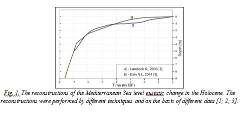
Later we [4; 2] have developed an alternative method for extraction the eustatic component from the set of local curves. Using a set of 22 local curves, the curve of the Mediterranean Sea level change during the Holocene was calculated (Fig.1, blue curve) [3]. As can be seen from Fig. 1, our curve is very close to the Lambeck curve. For the Black Sea such calculations have not yet been done, because almost all available in the literature curves of its level are not local, but are built with using data from different parts of the coast.
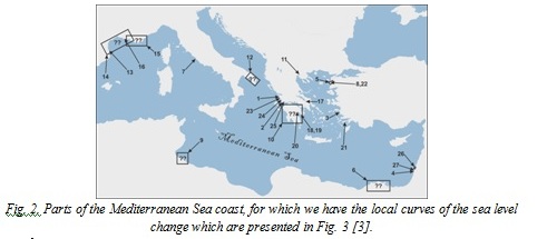
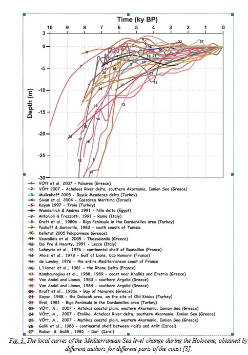
Using the obtained eustatic component we calculated the dynamics of the vertical movements of the Earth's crust during the last 7 thousand years in the 27 points of the Mediterranean Sea coast. Fig. 2 and 3 show respectively schematic map indicating coastal areas with the known local curves, and local curves of the Mediterranean Sea level change obtained by different authors. Graphs of the absolute vertical displacement of the Earth's crust are presented in Fig. 4.
.jpg)
Fig. 4 shows that the surface of the Earth is in constant motion. Figuratively speaking, it is as if "breathes". In some places it uplifts, in the other – falls, in the third periodically uplifts and lowers. In some areas, relatively short time fluctuations with relatively high velocities occur in the background of a more or less slow movement. Obviously, the movements of the Earth's crust are caused by constantly acting factors: the movement of plates, compressing the Earth's surface, temperature change, exogenous processes and other.
Results comparable to ours, but for much shorter time intervals, are obtained by employees of the GNC FGUGP "YUZHMORGEOLOGIYA" for several places of the Russian area of the Black Sea coast [5]. Vertical movements of the Erth surface were measured by the method of differential interferometry based on the high-resolution satellite radar TERRASAR-X. Parallel measurements were performed on the geodynamic satellite points by the GPS/GLONASS. Measurements were performed in 2012 and 2013. Significant velocities of vertical movements of the Earth's crust and complex short-period fluctuations, as with the trend of decreasing or uplifting, and without trend were recorded. According to the results of measurements, the velocity of lowering of some coasts can reach 20 mm/year. Therefore, we can assume that the abrasion processes, for example, on the coast of the Imereti Valley (Russia), are the result of the coast lowering. If not for this factor, the canyons peaks were covered with detrital material coming from the coast. But for thousands of years this has not happened, because there was the significant velocity of the coast lowering, and the longshore sediment flow is not enough to compensate the lowering of detrital material.
A particularly important and poorly understood is the question about the size of the Earth's crust block subjected to its own movement. According to satellite interferometry [5], fundamental differences, namely, the opposite vertical movements of the Earth's crust with the difference in velocities of more than 15 mm/year can occur closer than 10 km. The area of unidirectional sections can be 10 – 100 km2. This issue is extremely important. If, for example, there are two adjacent sections of the Earth's crust, the direction of movements of which is different, then on their border, we should expect the appearance of tectonic dislocations or the development of existing violations with possible catastrophic consequences.
III. Conclusion
Described in the report the various fluctuations in the Earth's crust, of course, have an impact on the infrastructure of a modern city. If to speak only about the widespread "slow" movements of the Earth's crust, they very weak, almost imperceptible impact on constructions accumulate over time and can lead to their destruction. In our opinion, the main reason for the destruction of many ancient cities could be weak crustal movements.
Considered vertical land movements can play a significant role in coastal processes. So, in areas of intensive lowering it will always be to develop the abrasion processes. Here all attempts to stop the abrasion of the coast through the creating of beaches will not be effective. These beaches will be washed away in the sea. A feature of such processes is that the cause of abrasion unknown, because the data on vertical movements of the coasts are almost absent. Therefore, experts will consider as a reason for the abrasion anything, but only not movement of the Earth's crust.
In the design of coastal economic facilities, recreational and other Human activities should pay attention not only to possible future eustatic changes in sea level, but also possible scenarios for the displacement of the Earth's crust, taking into account their temporal variability.
This article discusses only the vertical crustal movements directed along the normal to the Earth's geoid. But there's also horizontal movement of blocks, which in some cases are no less important and should be considered in the design of construction projects.
We can conclude that the dynamics of the vertical movements of the Earth's crust has a fractal nature. Previously this was not taken into account either in research or in applied research.
IV. Acknowledgment
The study was funded by RFBR according to the research project № 16-35-00441
1. K. Lambeck, and A. Purcell, “Sea-level change in the Mediterranean Sea since the LGM: model predictions for tectonically stable areas,” Quaternary Science Reviews, vol. 24, pp. 1969-1988, 2005.
2. N.V. Esin, and N.I. Esin, “Mathematical modeling of the Black Sea level change for the last 20000 years,” Quaternary International, Elsevier Ltd and INQUA, DOI:https://doi.org/10.1016/j.quaint.2014.05.026, vol. 345, pp. 32-47, 2014.
3. N.I. Esin, Dinamika urovnya Chornogo morya v poslednie 20 tysyach let [Dynamic of the Black Sea level during the last 20,000 years]. PhD thesis, PP Shirshov Institute of Oceanology, Russian Academy of Sciences, Moscow, 2014, p. 156 http://www.ocean.ru/disser/index.php/dissertatsii/category/23-esin.html (in Russian).
4. N.V. Esin, and N.I. Esin, “ Change in the Level of the World Ocean in the Holocene,” Doklady Earth Sciences, vol. 448, part 1, pp. 135-137, 2013.
5. E.A. Glazyrin, А.А. Marfin, and E.G. Gross, “Sostojanie nedr pribrezhno-shel'fovoj zony Azovo-Chernomorskogo i Kaspijskogo bassejnov Rossijskoj Federacii” [The subsurface status of the coastal-shelf zone of the Azov-Black Sea and Caspian Sea basins in Russian Federation], Informacionnyj bjulleten', Gosudarstvennyj nauchnyj centr FGUGP «JUZHMORGEOLOGIJA». Gelendzhik, p. 97, 2013 (in Russian).
6. A. Vött, “Relative sea level changes and regional tectonic evolution of seven coastal areas in NW Greece since the mid-Holocene,” Quaternary Science Reviews, vol. 26, pp. 894-919, 2007.
7. M. Müllenhoff, Geoarchäologische, sedimentologische und morphodynamischeUntersuchungenimMündungsgebiet des Büyük Menderes (Mäander), Westturkei: Dissertation … GeographischeSchriften: Marc Müllenhoff. - Marburg/Lahn: MarburgerGeograph, 2005. - 282 p.
8. J.C. Aloisi, A. Monaco, N. Planchais, J. Thommeret, and Y. Thommeret, “The Holocene transgression in the Golfe du Lion, southwestern France: paleogeographic and paleobotanical evolution,” Geogr. phys. Quat, vol. 32 (2), pp. 145-162, 1978.
9. T.H. Andel, and N. Lianos, “High-resolution seismic reflection profiles for the reconstruction of postglacial transgressive shorelines: an example from Greece,” Quaternary Research, vol. 22, pp. 31-45, 1984.
10. T.H. Andel, and N. Lianos, “Prehistoric and historic shorelines of the southern Argolid Peninsula: a subbottom profiler study,” Int. J. Naut. Archaeol. Underw. Explor, vol. 12 (4), pp. 303-324, 1983.
11. F. Antonioli, “Geomorfologiasubacquea e costieradellitoralecompresotra Punta Stendardo e Torre S. Agostino (Gaeta),” Il Quaternario, vol. 4 (2). pp. 257-274, 1991.
12. G. Dai Pra, and P.J. Hearty, “VariazionidelLivello del Mare sulla Costa IonicaSalentinaduranteL'Olocene: Epimerizzazionedell'Isoleucina,” Helix sp. Memoire Soc. Geol. d'Italia, vol. 42, pp. 11-320, 1989.
13. O. Erol, Summary report from Turkey. Sea-Level. Inf. Bull. IGCP Proj. 61. pp. 20-21, 1981.
14. E. Galili, M. Weinstein-Evron, and A. Ronen, “Holocene sea-level changes based on submerged archaeological sites off the northern Carmel coast in Israel,” Quaternary Research, vol. 29, pp. 36-42, 1988.
15. E. Kambouroglou, H. Maroukian, and A. Sampsos, “Coastal evolution and archaeology north and south of Khalkis (Euboea) in the last 5000 years,” Archaeology of Coastal Changes, Raban A. (Editor), Oxford: BAR Int. Ser., vol. 404, pp. 71-79, 1988.
16. E. Kambouroglou, Eretria: Paleogeographic and Geomorphological Evolution During the Holocene - Relationship Between Ancient Environment and Ancient Inhabitation : Ph.D. Thesis, Univ. Athens. Publication of the Municipality of Eretria, Athens, p. 220, 1989.
17. I. Kayan, “Bronze Age regression and change of sedimentation on the Aegean Coastal plains of Anatolia (Turkey),” Third Millennium BC Climate Change and Old World Collapse, Dalfes H.N., Kukla G., Weiss H. (Eds.). Berlin: NATO ASI, pp. 431-450, 1997.
18. I. Kayan, “Late Holocene sea-level changes on the western Anatolian coast,” Palaeogeography, Palaeoclimatology, Palaeoecology, vol. 68, pp. 205-218, 1988.
19. D. Kelletat, “A Holocene sea level curve for the eastern Mediterranean from multiple indicators,” Zeitschrift fur Geomorphologie N.F. 137 (Supplement), pp. 1-9, 2005.
20. J.C. Kraft, I. Kayan, and O. Erol, “Geomorphic reconstructions in the environs of ancient Troy,” Science, vol. 209 (4458), pp. 776-782, 1980b.
21. J.C. Kraft, G.R. Rapp, and S.E. Aschenbrenner, “Late Holocene palaeogeomorphic reconstructions in the area of the Bay of Navarino: Sandy Pylos,” J. Archaeol. Sci., vol. 7, pp. 187-210, 1980a.
22. J. Labeyrie, C. Lalou, A. Monaco, and J. Thommeret, “Chronologie des niveauxeustatiquessur la cdte du Roussillon de -33 000 ans BP h nosjours,” C.R. Acad. Sci., D., vol. 282, pp. 349-352, 1976.
23. A. L'Homer, F. Bazile, J. Thommeret, and Y. Thommeret, “Principalesetapes de l'edification du delta du Rhone de 7000 BP a nosjours; variations du niveaumarin,” Oceani, vol. 7 (4), pp. 389-408, 1981.
24. H. Lumley, “Les lignes de ravage enFrsnce,” In book: La Prehistoirefrancaise. - Paris: CNRS, vol. 3, pp. 24-26, 1976.
25. R. Paskoff, and P. Sanlaville, “Les côtes de la Tunisie. Variations du niveaumarindepuis le Tyrrhénien,” Lyon: Maison de l'OrientMediterraneen, p. 192, 1983.
26. A. Raban, and E. Galili, “Recent maritime archaeological research in Israel,” A preliminary report. Int. J. Naut. Archaeol. Underw. Explor, vol. 14(4), pp. 321-356, 1985.
27. K.G. Vouvalidis, G.E. Syrides, and K.S. Albanis, “Holocene morphology of the Thessaloniki Bay: impact of sea level rise,” Zeitschrift fur Geomorphologie N.F. 137 (Supplement), pp. 147-158, 2005.
28. J. Wunderlich, and W. Andres, “Late Pleistocene and Holocene evolution of the western Nile delta and implications for its future development,” Von der NordseebiszumIndischenOzean. ErdkundlichesWissen, Bruckner H., Radtke U. (Eds.), pp. 105-120, 1991.