


BISAC NAT010000 Ecology
BISAC NAT045050 Ecosystems & Habitats / Coastal Regions & Shorelines
BISAC NAT025000 Ecosystems & Habitats / Oceans & Seas
BISAC NAT045030 Ecosystems & Habitats / Polar Regions
BISAC SCI081000 Earth Sciences / Hydrology
BISAC SCI092000 Global Warming & Climate Change
BISAC SCI020000 Life Sciences / Ecology
BISAC SCI039000 Life Sciences / Marine Biology
BISAC SOC053000 Regional Studies
BISAC TEC060000 Marine & Naval
The interest to study the processes in the Imeretinka lowland increases in the last years due the few reasons. The main structures of so-called “coastal cluster” of Olympic Games 2014 built in this area. Some of planned structures effected significantly the coastal processes; they are the seaport near the river Mzimta mouth and coastal protection. The natural coastal processes in the area complicated by the effects of the underwater canyons. The natural-technogenic system requires the study with using the methods of modeling and monitoring. Wave climate of Imeretinka lowland coast estimated based on long-term data of meteorological fields above Black Sea with modeling of wave transformation in nearshore zone by the gentle slope equations. Such approach provides possibilities to assess the effect of the designed coastal protection structures on the changes of the wave parameters in nearshore zone. Numerical modeling of currents in the Black Sea using 3D circulation model with refinement in the region of canyons of the Imeretinka coast obtained. To estimate the sediment transport, 3D Lagrangian multifraction sediment transport model LagrSed is used. 2D flow fields, free-surface level and wave characteristics calculated, using 2D hydrodynamic model of the coastal zone. It has presented the few years story of modeling and monitoring of the coastal processes with the important lessons.
coastal zone, Black Sea, Sochi region, Imeretinka lowland, coastal protection project, coastal processes, mathematical and physical modelling, monitoring
I. Introduction
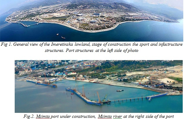
The important area of the Russian Black Sea coast is the Sochi region, the Olympic Games 2014 city. The serious part of the Olympic Games infrastructure is built in the Imeretinska lowland. That is the very special area of the Sochi city coast with duration along shore in about 8 km (Fig.1). The lowland had been generated historically by the flow of solid matter of the two rivers: Mzimta and Psou. Due the good supply by the sediments from rivers the coast had the stable fine gravel beach with the wide of the overwater part about 50 m. The actual solid matter flow of Mzimta river is about 20-45 thousand cubic meter per year. About 80-85% of the total flow had been transported by the longshore currents to the east and nourishes the beaches of the area.
To supply the global construction works it was decided to build the new cargo port in the area of river Mzimta mouth, at the western bound of the area (Fig.2). The protective piers of the port are reached the water depth in 10 m, and, as the result, the longshore flow of sediments from river to beaches had been interrupted. That is the classical mistake in shore management and the repeat of the similar mistake have been made in 1930-1935, when the main Sochi sea port had been placed in the month of the river Sochi. As the result, the area has the very serious problems with beach erosion until this time.
II. Study of the coastal processes
The situation of the Imeretinka lowland coast is complicated by the effect of the underwater canyons in the coastal zone. In the Fig. 3, it has shown the underwater relief of the sea bottom, from which the very close position of the canyons to shore is understandable. The canyons work as the traps for the beach material what can moves to the deep water by the gravitational flow.
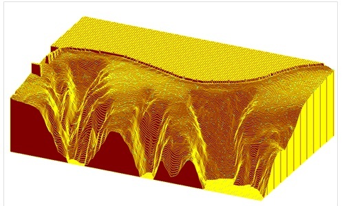
Fig.3. Bottom relief of Imeretinka coastal zone. Numerical reconstruction by Dr.V.Shakhin
The authors with colleagues carried out the complicated mathematical modeling of the coastal processes. That includes the following study: beach stability and effect of the protective moles on the lytodynamic processes; wind and deep water waves; waves and water set up at the sea edge of the coastal area; waves in the shallow water; longshore currents, transport of sediment, changes of bottom and beaches; current field in the area of canyons; stability of the shore protection structures.
The modeling based on the monitoring of the natural coastal processes what carried out in previous years.
Heterogeneity of bottom topography, rugged by deep-sea canyons, defines the feature of formation of wave regime. Therefore, the most dangerous to the coast near Canyon “Novyi” (New), storms from the southern and southwestern directions, which are suitable to the shore along the canyon.
Within the framework of the project on modelling of hydrodynamic and litodynamic coastal zone regime before and after the construction of the coastal protection structures [1], transformation of wave fields in deep water areas and near shore to shoreline studied by applying models SWAN and HWAVE [2].
Important problem of modeling of run-up of the extreme waves on protected dam and erosion of gravel-pebbles beach in splash zone under the influence of the dynamics of the overtopping stream. Simulation of these processes was based on models COASTOX-MORPHO [2,3] that can be used to calculate the longshore currents generated by the waves, the waves are considered as undergrid processes magnitude affecting the hydrodynamics only through stresses (through radiation stress and bottom friction) [3] and to directly describe the equations of shallow water waves run-up on the shore processes [2].
The results of the integrated modeling of the coastal processes are very helpful and may be used for searching of the optimal solution. Unfortunately, the modeling has been done not before the construction works, but after them.
As an example, the numerical modeling of the coastal waves in the canyon area is shown in Fig.4.
During the storm impact shore profile strives to take equilibrium form, which satisfies the minimum gradients of sediment discharges [4]. Bottom deformation reflects the process of the formation of the equilibrium profile. The closer the initial profile to equilibrium one, the smaller changes it is experiencing.
The alongshore distribution of the integral sediment discharges are shown in Fig.5.
Distribution of the storm deformations on some profiles under the action of southwestern directions storms of varying frequency of occurrence are shown in Fig. 6. A common feature of derived distributions is that in all cases indicated dredging near the line, moving material down the slope and its accumulation in the bottom of the profile. These trends are quite consistent with observations for storm changes pebbly beaches.
In the light of the results obtained, the most vulnerable are the cross sections of the shore 18 and 28, where the coastal slopes breaks to the canyons in offshore direction. When storm impacts sediments washed off the beach, move down and irretrievably lost.
In other areas, in general, more favorable conditions and do not cause fear. Cross section profiles 22, 32 and 41 storm washouts in total do not exceed 0.4 m. Cross section profile 30 underwater slope may be eroded to a considerable depth, but the beach at the same time is growing.
To maintain the beaches at designated sites will require regular filling pebble material in the volume shortfall, determined based on the results of monitoring.
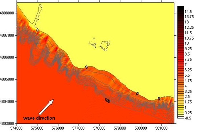
Fig.4. Result of numerical modeling of the waves in the coastal zone. The effect of canyons onto the waves
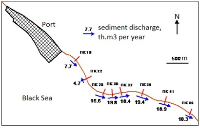
Fig.5. Scheme of the alongshore sediment transport with estimation of the rates
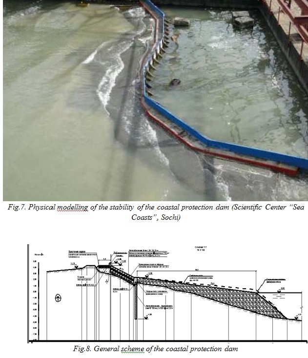
Experimental research on determination of coastal protection ability of dam constructions for Imeretinka lowland were held at the wave basin (Fig.7). In accordance with the chosen scale: 1 : 80 in the wave pool was built model reporting plot shore and bottom up to 70 m water depth, with longshore length 1600 m, from cross section 16 to 32.
Projected coastal protection structures with the beach 50 m wide, explored in the second series of experiments, not fully clearing waves in the zone of canyons at storm the southern and West-South-West directions. Surf zone flow with breaking of these waves crosses the shingle beach and overflowing on high mount and poured through it.
III. Realized coastal protection
Currently, the beaches of Imeretinka lowland coast located to the East coast from the mouth of r. Mzymty, lack of sediment nutrition. Particularly dangerous situation created in areas of canyons Novyi and Constantin, which absorb sediments and move deeper into shore. The existing situation, to some extent, can be corrected by adding a certain amount of beach material to the litodynamic system. It is this way to reinforce the shore will be offered for sale because of the construction of coastal protection dam (Fig. 8). At the top of the stacked concrete blocks, but below 2.5 m the pebble beach 50 m wide is built.
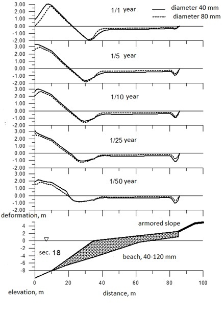
Fig.6. Erosion and accumulation of the coast profile, section 18, mathematical modeling
The natural result of the sediment balance disturbance is the shore erosion to the east of the port structures. The area is planned as the recreation area for the Olympic Games and for the region. So it was decided to construct the shore protection to conserve the beaches.
The proposed shore protection includes the along shore dam what includes the beach 50 m wide, concrete slope protected by perforated units or concrete desks with slope 1:5 and with based by the sea end on the concrete cushion (Fig.8).
Due the absence of the correct date on the dynamic behavior of the canyons, the level of risks of coastal damage is not understandable. By that it was decided to strange the coastal protection in the dangerous areas, which are connected with the canyon mouths.
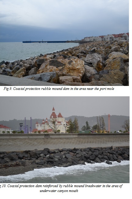
Rubble mound dam with stones 3-5 tons – Fig.9, covered about 200 m of the coast near port mole. Moreover, few areas opposite the canyon mouths are strange by stones 10-30 kgs – Fig.10.
IV. Monitoring project
A very brief description of the project developed on coastal protection integrated monitoring for Imeretinka lowland is presented below. Comprehensive monitoring on the territory of the Imeretinka lowland is composed of:
1. Geotechnical monitoring for changes in the physic-mechanical characteristics of natural and anthropogenic soils in process engineering protection activities.
2. Hydrogeological monitoring and regime-formatted factors of groundwater territory and changes forecasting hydrogeological conditions in time under the influence of engineering activities.
3. Monitoring the safety and reliability of protecting structures.
4. Monitoring of the coastal protection before, during, and in the period of operation of the structures, with the aim of identifying the early stages of development of dangerous existing lithodynamic processes.
5. Environmental monitoring during the works on engineering protection of territory of Imeretinka lowland.
For the prediction of the conditions of nature and man-caused geological system and structures of artificial protection, it is planned the mathematical modeling of stress-strain state of ground array and its changes over time in the zones of most responsible sites of geo-systems and installations of artificial protection.
Comprehensive project monitoring is designed based on data from geotechnical surveys, based on the terms of the construction and initial data for project development. Integrated monitoring you intend to in two phases over four years (first period).
The first stage is preparatory one and includes the following works:
Adjustment of the integrated monitoring programme;
The creation of the locomotive and observation network device with wells and geodetic marks;
The establishment of mathematical models;
Organization of integrated monitoring.
Second stage - observations includes works by:
Measurements of parameters to be monitored;
Operational control;
The collection and analysis of information, the creation of a database;
Evaluation of stress-strain state of inhomogeneous ground array and state of environment and forecast natural and technogenic geosystem and engineering protection and constructions;
Preparation of accounting documentation.
Safety monitoring tasks of protecting structures.
1. Development of monitoring programmes.
2. Monitoring of local deformations of slopes and ridges structures.
3. Conducting geodetic control values by definition of vertical offsets (sludge, drawdowns, and upgrades) and horizontal offsets of the shifts and the banks structures.
4. Conduct a comprehensive assessment of the state of installations and their operational reliability, to develop recommendations to ensure the safety of structures.
Litodynamic monitoring tasks.
1. Litodynamic monitoring program development, taking into account the planned technical solutions and assess the possible impact of protecting structures on the progress of existing lithodynamic processes in the coastal zone of the sea.
2. Measurements of the width of the beach on a stretch of coastal protection, sampling and analysis on granulometric analysis of beach sediments.
3. Conduct a survey of the beach surface to a depth of 1 m, bathymetric shooting from the water line to a depth of 20 m.
4. Diving survey of the bottom surface to a depth of 20 m with a sampling of surface sediments for granulometric analysis, as well as diving survey tops canyons "Mzymta River", "New" and "Constantine" with a view to assessing the dynamics of sediment in their upper reaches.
5. Evaluation of existing lithodynamic processes features and effectiveness of the project on engineering protection of coast activities during construction and operation of the coastal structures. Validation and adjustment of the existing lithodynamic predictions of dangerous existing lithodynamic processes during construction and operation of the coastal protection.
V. Conclusion
Coastal protection for complex projects, such as the complex of buildings in the Imeretinka lowland, the project must provide for integrated monitoring of coastal processes and structures under construction. Such monitoring allows you to monitor the situation during the operation of the facilities and make the better decisions.
To implement an integrated dashboard, you must at the design stage to develop the necessary tools for monitoring of natural processes and state of structures. Information obtained through such monitoring, is used for the development of mathematical models of processes.
Coastal protection complex for Imeretinka lowland, created in 2011-2014, not fully implements this principle. In the design phase the mathematical models of coastal processes have been created, which take account of the real characteristics of the area. Including the effect of submarine canyons and seaport facilities. Using physical modelling and comparison with existing data studies it has been shown that models adequately reflect real processes.
However, the developed project of monitoring was not implemented, resulting in the need to make intuitive decisions on protection of dangerous sections of coast. The degree of risk is uncertain.
VI. Acknowledgment
We thank to our colleagues and assistances: Natalia Shunko (Moscow State Civil Engineering University), Igor Brovchenko, Pavel Dikiy, Natalia Dzyuba, Maxim Sorokin, and Pavel Kolomiets (Ukrainian Center of Environmental and Water Projects) who contribute to the present research.
1. I. Kantardgi and K. Mordvincev, “Mathematical modelling of the coastal processes to support the shore protection of the Imeretinsky lowland,” Int. J. for Computational Civil and Structural Eng., vol.7, issue 2, pp. 64-71, 2011.
2. P. Dikiy, N. Dzyuba, M. Zheleznyak, and M. Sorokin, “Modelling of wave climate of Imeretinsky lowland coast,” Int. J. for Computational Civil and Structural Eng., vol.7, issue 2, pp. 54-63, 2011.
3. S.Kivva and M. Zheleznyak, “2-D modelling of water yield and sediment transport from the small aquilegia,” Applied Hydromechanics, vol. 4(76), issue 1, pp. 67-89, 2002
4. I. Leont’yev, “Dynamics of the sand coast profile on the various time scales,” Fundamental and Applied Hydrophysics, no.4 (10), pp.78-89, 2010.