


BISAC NAT010000 Ecology
BISAC NAT045050 Ecosystems & Habitats / Coastal Regions & Shorelines
BISAC NAT025000 Ecosystems & Habitats / Oceans & Seas
BISAC NAT045030 Ecosystems & Habitats / Polar Regions
BISAC SCI081000 Earth Sciences / Hydrology
BISAC SCI092000 Global Warming & Climate Change
BISAC SCI020000 Life Sciences / Ecology
BISAC SCI039000 Life Sciences / Marine Biology
BISAC SOC053000 Regional Studies
BISAC TEC060000 Marine & Naval
The research of geocryological structure of the coasts is important in the planning and construction of infrastructure in permafrost zone. Long-term monitoring of temperature regime of the Arctic coastal zone soils needs to predict the steady state of the object during its operation and prevent possible negative consequences resulting from interruption of the steady state. It is especially important in conditions of today's climate change, as well as the possibility of warming effect of engineering facilities (for example pipelines). The results of a study of the coastal seasonally frozen cap, formed in the contact zone of freezing fast ice to the bottom are presented by the examples of the Mys Kamenniy settlement at the Gulf of Ob coast (Kara Sea) and Varandey settlement at the Pechora Sea areas. The technology of the monitoring station establishment for the geocryological statement and temperature regime of the Arctic coastal zone observations is proposed based on the conducted field works experience.
cryolithozone, sea coast, permafrost, coastal thermoerosion, accumulative shores, cryopeg, talik
I. Introduction
The research of geocryological structure of the coastal zone is important in the planning and construction of infrastructure Arctic coastal zone in order to reduce the financial losses at the construction phase of these objects.
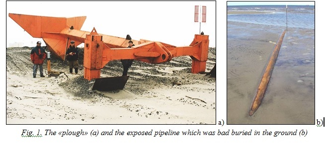
An example of the negative consequences of ignoring of the coastal zone geocryological structure is the first phase of construction of an underwater pipeline to the Varandey Oil Export Terminal (Pechora Sea). The builders did not move "plough" (Fig. 1a) used to trench dredging that drove in coastal seasonally frozen cap which has formed in the contact zone of freezing fast ice to the bottom (so-called “visor of seasonally frozen ground” in literal translation from Russian into English). The presence of this cap was a surprise [1]. As a result of bad buried in the ground (Fig. 1b) 4 km long pipeline in shallow water was pulled from the bottom under the influence of sea ice and through away on the coast as a thin straw [2].
Long-term monitoring of temperature regime of the Arctic coastal zone soils needs to predict the steady state of the object during its operation and prevent possible negative consequences resulting from interruption of the steady state. It is especially important in conditions of today's climate change, as well as the possibility of warming effect of engineering facilities (for example pipelines).
The greatest contribution to the study of the geocryological structure and temperature of soils of the Arctic coastal zone have works by N.F. Grigoriev [3], L.A. Zhigarev [4] and A.N. Khimenkov and A.V. Brushkov [5]. Most of these researches have short-term observations.
The aim of this paper is proposal of the technology of the long-term monitoring station establishment for the geocryological statement and temperature regime of the Arctic coastal zone observations after reviewing several examples of field investigations.
II. geocryological structure features of thermoerosion and accumulative shores
Reference [3] was one of the first work where the geocryologial structure differences which depend on the history of sea coasts evolution. N.F. Grigoriev [3] allocated three cryolithozones in Western Yamal coastal area: sub-aerial, sub-aerial-erosion and sub-sea (shallow waters).
Sub-aerial cryolithozone is typical for both thermoerosion and accumulative shores. It is not exposed to direct influence of the sea at the present time.
Sub-aerial-erosion cryolithozone is transitional zone between sub-aerial and sub-sea cryolithozones and typical only for thermoerosion shores. It is located at the foot of the coastal bluff both in sub-aerial and sub-sea (under modern ice-bonded permafrost and cryotic talik) positions and presented itself part of sub-aerial cryolithozone which was recently destroyed after coastal erosion and covered by beach deposits. The main characteristic of sub-aerial-erosion cryolithozone is proximity of the relict permafrost-table to the surface which is lowered with increasing distance from the shoreline. The temperature of deposits is increased in the same direction.
Sub-sea cryolithozone is typical for both thermoerosion and accumulative shores. Its development takes place in conditions of active processes of erosion and accumulation. There are two types of permafrost: modern (Holocene) ice-bonded permafrost and cryotic talik. The first type is formed as the pereletok during seasonal freezing of accumulative landforms of submarine coastal slope (beaches, coastal ridges, bars, barriers. spits, islands, fans and deltas) on the contact of the fast ice with the seabed (coastal seasonally frozen cap). Such freezing take place until the water depth which equal to the thickness of ice (generally it is less than about 1.5-2 m). Accumulation processes are lead to increasing thickness of the modern ice-bonded permafrost which underlain by a relict permafrost, or cryotic talik and can contain highly saline talik layers and lenses (cryopegs).
Cryotic talik has no ice despite the temperature below 0°С. This is due to saline pore-water (cryopegs) which contained in sediments instead ice-cement. It is located at the water depth more than 2 m and under the modern ice-bonded permafrost until 2 m water depth. Cryopegs in the cryotic talik can have the temperature below -8°С.
III. Examples of field investigations
Investigations of permafrost and seasonal freezing in coastal zones in the areas of Mys Kamenniy settlement (west coast of fresh water Gulf of Ob, Kara Sea) and Varandey settlement (Pesyakov Island, Pechora Sea) included core and auger drilling, drill rods penetrating into active layer (by the compact portable rig UKB-12/25) and temperature measurements in boreholes with a thermistor strings. Both key sites have close geomorphological structure. Mys Kamenniy is lowland fine sand spits (3-5 m high). Pesyakov Island is also lowland sandy barrier island but it has dune belt facing sea side (5-12 m high).
Mys Kamenniy settlement (the Gulf of Ob coast, Kara Sea)
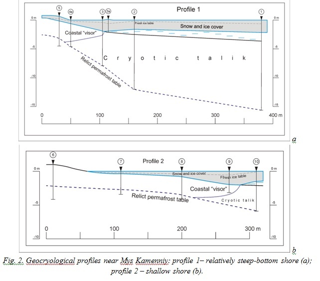
Drilling in the area of Mys Kamenniy was taken in May 2012 from fast ice to determine depth and width of the coastal "visor" under fast ice and depth of permafrost table under water layer [6, 7].
In order to determine the depth of seasonal freezing and the limit of its spread the drilling from the fast ice was carried out on two profiles at the end of the cold season (from 11 to 23 May 2012), when freezing up have a maximum depth. 5 boreholes were done for each profile (Fig. 2). Profile 1 was located at a relatively steep-bottom shore, and the profile 2 – at shallow shore. It is worth noting that although the Gulf of Ob is a part of the Kara Sea, the water is fresh. It imposes some specific to the freezing of the bottom sediments.
The thickness of the seasonal frozen layer (when the frozen deposits are underlain thawed ground) reaches 3 m. The width of the longshore zone of seasonal frozen ground is about 70 m. The temperature of the seasonal frozen layer varies from -0,3°C to -1,5°C.
Permafrost roof plunges from a depth of 3 m near the shore line to 11 below the bottom of the Gulf of Ob at a distance of 400 m from the shore line.
The width of the contact zone of fast ice with bottom depends on the topography and incline of the submarine coastal slope and snow cover and fast ice thickness. If the thickness of fast ice is about 2 m, width of contact zone varies from 100 m at a relatively steep-bottom shores up to 300 m on the shallow shores.
Varandey settlement (Pechora Sea)
Drilling in the area of Varandey was taken in July 2012 at different landforms of Pesyakov Island (beach, laida, coastal barrier and dune belt) to determine depth of permafrost table and temperature of frozen ground [7, 8].
Body of barrier (excluding laida) is composed from well-sorted and well washed mid-fine sands. Sediments of laida have higher content of fine graines (fractions smaller than 125 μm compose 2-12%), and have lower mid-grained sand fraction 250-500 μm (16-18%). Fine-grained fraction fraction 125-250 μm is dominating (76-82%).
The thickness of seasonally-thawed ground at the moment of drilling was 0.8 m on the upped laida, 2.2 m on the terrase barrier surface, 4 m on the top of dune belt, and more than 8 m on the tidal flat. The average elevation of permafrost table in barrier terrace is about 1-2 m higher than sea level. High of permafrost table raises at positive relief forms (on dune belt – up to 2.5 m about above sea level), and sinks below the sea level on the upper beach.
Horizons and lenses of cryopegs (lenses of saline water brine) were found below permafrost table. Cryopegs were found on the depth 0-2.5 and 3.5-7 m below sea level. Water in cryopegs were under pressure. Water level in boreholes where cryopegs were found rised up on 4.5 m above the assumed level stratigraphy level of cryopegs [8].
The temperature of the top of permafrost at laida in summer is -1°C...-2°C. In the same time the temperature of the top of the permafrost at avandune (which located closer to open sea) in summer does not fall below 0°C. Probably, this is due to the warming effect of the sea.
For the time of drilling lenses of seasonally frozen ground were revealed in the barrier terrace (lower part of active layer) and on the upper part of beach (coastal seasonally frozen cap). They were 0.5-0.6 m thick on the depth 1.5 m, and on the upper part of beach lens was 0.3-0.5 m on the depth 2.2 m.
The lens of seasonally frozen ground at the barrier terrace was attached to permafrost table in some locations, but more often there was layer of unfrozen highly saturated soil between seasonally frozen ground and permafrost table. Lens of seasonally frozen cap, most probably adjoined to steep slope of permafrost core of barrier, and most probably present degraded remains of seasonally frozen ground which form due to adfreezing of land fast ice to the beach (Fig. 3).
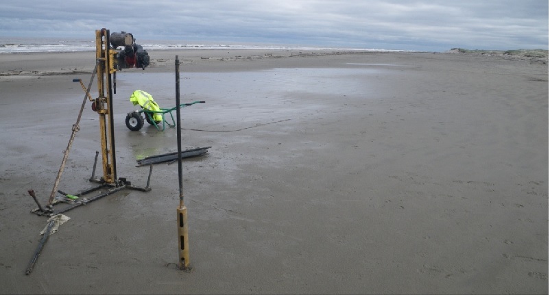
Fig. 3. The strip of the wet deposits on the surge berm marks lense of seasonal frozen ground which still hasn’t thawed (Pesyakov Island, Pechora Sea). 2012 July. The compact portable rig UKB-12/25 in the foreground.
IV. The technology of the long-term monitoring station establishment
Based on the conducted field works experience and previous investigations [3‑5, 9‑12] the technology of the long-term monitoring station establishment for the geocryological statement and temperature regime of the Arctic coastal zone observations is proposed. That technology is introduced in conceptual scheme for thermoersional coast (Fig. 4) because it has all three cryolithozones of the Arctic coasts. Besides, this scheme assumes that the drilling is carried out with the compact portable rig UKB-12/25 (Fig. 3).
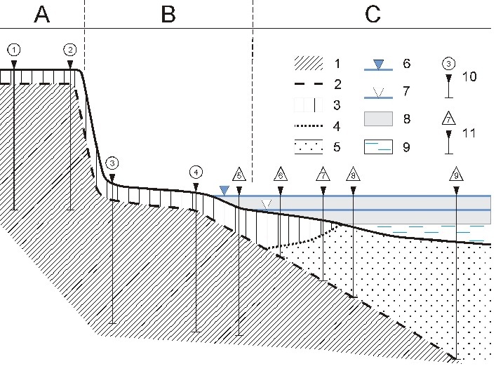
Fig. 4. The conceptual scheme of the long-term monitoring station for the geocryological statement and temperature regime of the Arctic thermoerosional coast observations: 1 – ice-bonded relict permafrost; 2 – table of ice-bonded relict permafrost; 3 – active layer (seasonally frozen and thawed grounds); 4 – bottom of active layer; 5 – cryotic talik; 6 – high tide; 7 – low tide; 8 – fast ice; 9 – sea; 10 – boreholes drilled from the ground (long-term year-round temperature measurements); 11 – boreholes drilled from the ice (repeated single temperature measurements in the winter season). Cryolithozones: A – sub-aerial, B – sub-aerial-erosion, C – sub-sea.
The long-term monitoring station for the geocryological statement and temperature regime of the Arctic coastal zone observations presents itself profile which consists of a series of boreholes. One part of boreholes can be drilled from the ground all year round. They are situated in sub-aerial and sub-aerial-erosion cryolithozones. A thermistor strings with data logger should be installed in each of them for long-term year-round temperature measurements. The number of boreholes depends on the complexity and variety of sub-aerial cryolithozone relief and extension of sub-aerial-erosion cryolithozone. If the sub-aerial cryolithozone is represented by a flat terrace then two boreholes are enough because in this case isotherms are parallel to ground surface and a large gradient is observed only near the coastal bluff. If the sub-aerial-erosion cryolithozone is represented by a narrow beach then two boreholes are also enough (near the foot of the coastal bluff and near the high tide level).
Another part of boreholes should be drilled only from the fast ice in the winter season. They are situated in sub-aerial-erosion and sub-sea cryolithozones. Only repeated single temperature measurements in winter season can be done here. The number of boreholes has defined by parameters of the coastal seasonally frozen cap. The minimum number of boreholes should be five.
Such monitoring station should be kind of coastal permafrost “meteorological station”.
V. Acknowledgment
The work was executed with the financial support of the Russian Science Foundation project No. 16-17-00034.
1. S.A. Ogorodov, V.V. Arkhipov, A.V. Baranskaya, N.G. Belova, A.P. Vergun, A.M. Kamalov, O.V. Kokin, N.V. Kopa-Ovdienko, D.E. Kuznetsov, N.N. Shabanova, “Technogenic factor of coastal dynamics of the Pechora and Kara seas under the conditions of climate and sea ice extent changes”, in Proccedings of the XXV International coastal conference “Coastal zone: a prospective into the future”, vol. 1. Moscow: GEOS, 2014, pp. 114-117 (in Russian).
2. N.A. Chernikov, Duga Barkova (Barkov’s Arc). Publishing house of the magazine “Smena”, 2006, 238 p. (in Russian).
3. N.F. Grigoriev, Cryolithozone of Western Yamal coastal area. Yakutsk: IMZ of the SR AS USSR, 1987, 112 p. (in Russian).
4. L.A. Zhigarev, Oceanic Cryolithozone. Moscow: Moscow State University Press, 1997, 319 p. (in Russian).
5. A.N. Khimenkov, A.V. Brushkov, Oceanic Cryolithogenesis. Moscow: Nauka, 2003, 335 p. (in Russian).
6. O.V. Kokin, A.S. Tsvetsinsky, “Geocryological structure of the underwater coastal slope in the Obskaya Bay in the contact area with the fast ice”, News of gas science, № 3 (14). 2013, pp. 67-69 (in Russian).
7. A. Abramova, A. Kirillova, O. Kokin, “Permafrost and seasonal frozen ground in coastal zones of Kara and Pechora seas” in International Conference Permafrost in XXI century: basic and applied researches, vol. 1. Pushchino: 2015, pp. 127-128.
8. E. Guégan, A. Sinitsyn, O. Kokin, S. Ogorodov, “Coastal geomorphology and ground thermal regime of the Varandey area, Northern Russia”, Journal of Coastal Research, in-press.
9. V.P. Melnikov, V.I. Spesivtsev, Geotechnical and geocryological conditions of Barents and Kara Sea shelf, Novosibirsk: Nauka, 1995, 198 p. (in Russian).
10. P. Overduin, S. Wetterich, F. Gunter, M.N. Grigoriev, G. Grosse, L. Schirrmeister, H.-W. Hubberten, A. Makarov. “Coastal dynamics and submarine permafrost in shallow water of the central Laptev Sea, East Siberia”, The Cryosphere Discuss., № 9, 2015, pp. 3741 3775.
11. M.N. Grigoriev, Cryomorphogenesis and Lithodynamics of the Coastal-shelf Zone of the Seas of Eastern Siberia, doctoral thesis, Yakutsk Melnikov Permafrost Institute, 2008, 40 p.
12. E.M. Chuvilin, B.A. Bukhanov, V.E. Tumskoy, N.E. Shakhova, O.V. Dudarev, I.P. Semiletov, “Thermal conductivity of bottom sediments in the region of Buor-khaya bay (shelf of the Laptev Sea)”, Earth Cryosphere, 17 (2), pp. 32 40.