


Россия
BISAC NAT010000 Ecology
BISAC NAT045050 Ecosystems & Habitats / Coastal Regions & Shorelines
BISAC NAT025000 Ecosystems & Habitats / Oceans & Seas
BISAC NAT045030 Ecosystems & Habitats / Polar Regions
BISAC SCI081000 Earth Sciences / Hydrology
BISAC SCI092000 Global Warming & Climate Change
BISAC SCI020000 Life Sciences / Ecology
BISAC SCI039000 Life Sciences / Marine Biology
BISAC SOC053000 Regional Studies
BISAC TEC060000 Marine & Naval
Studying of methane formation and distribution in natural waters is important for understanding of biogeochemical processes of carbon cycle, searching for oil and gas sections and evaluation of CH4 emissions for investigations of greenhouse effect. The Black Sea is the largest methane water body on our planet. However, relatively low values of methane concentration (closed to equilibrium with the atmospheric air) are typical of the upper aerobic layer. At the same time, the distribution pattern of CH4 in surface waters of coastal areas is complicated by the influence of coastal biological productivity, continental runoff, bottom sources, hydrodynamic processes and anthropogenic effect. The investigation is focused on the spatial variability of dissolved methane in the surface layer of the sea in coastal regions affected by the continental runoff and anthropogenic pressure. Unique in situ data on methane concentrations were collected along the ship track on 2 sections between Sochi and Gelendzhik (2013, 2014) and 2 sections between Gelendzhik and Feodosia (2015). Overall 170 samples were obtained. Gas-chromatographic analysis of the samples revealed increase of CH4 saturation in the southeastern part of the Crimean shelf and the Kerch Strait area. Such a pattern was apparently caused by the influence of the Azov Sea water spread westward along the Crimean shore from the strait. This work was supported by the Russian Science Foundation, Project 14-50-00095 and the Russian Foundation for Basic Research, Project 16-35-00156 mol_a.
the Black Sea, methane, coastal waters
I. Introduction
Studying of methane formation and distribution in natural waters is important for solving of fundamental and applied problems of present science. Methane in connection with other matters is significant indicator of processes of biogeochemical cycle. It allows estimating pollution degree of seawater [1]. Evaluation of methane concentration in water is also essential for searching of oil and gas sites of ocean bottom [2]. Besides, methane is a greenhouse gas; its activity exceeds activity of carbon dioxide 20 times [3]. That is why estimation of CH4 emission to the atmosphere is important. The Black Sea is the largest methane reservoir in the world. Due to peculiar structure of the sea, numerous studies of methane saturation in it refer to anaerobic layer where there is a significant increase of concentrations to 13∙103 nM/l [4]. As usual, methane saturation in surface water of aerobic zone of open ocean is close to the equilibrium to the atmospheric air. However, these concentrations may increase on 1 – 3 orders while approaching the shore [5]. Thus, studying of methane formation, consumption and accumulation mechanisms in coastal waters is of great interest. There are a number of studies on this subject that refer to the western coast of the Black Sea [6], northwestern shelf [7], area of the Crimean Peninsula and the Kerch Strait [1], northeastern coast [2], Georgian sector [8]. Among the reasons of heightened methane saturation of coastal waters of the Black Sea there are methane formation in situ and allochthonous supply of organic matter of natural and anthropogenic origin with continental runoff [1]. It is considered that gas emissions of cold seeps and mud volcanoes make a significant contribution to the budget of methane in the Black Sea [8, 9]. The northeastern part of the sea is characterized by the presence of combination of factors that influence the formation of methane concentration fields in the water column. These include water bioproductivity, the Azov Sea water spreading through the Kerch Strait, seabed gas showings, continental runoff and anthropogenic pressure. Particular effect of these factors was investigated earlier in various regions of northeastern part of the Black Sea. In presented study we consider results of field measurements of methane concentration in surface coastal waters of whole northeastern part of the Black Sea and estimate the complex of factors that affect the formation of particular methane distribution pattern.
II. Study Site
The study site in our work covers area from southeastern shelf of the Crimean Peninsula to the coastal zone of Sochi. Data on dissolved methane concentration in waters were obtained in four sections along the coast of Russian sector of the Black Sea on the research vessel “Ashamba”: two southern ones (Sochi – the Golubaya Bay of Gelendzhik May 25 – 26, 2013 and Adler – the Golubaya Bay May 31 – June 1, 2014) and two northern ones (the Golubaya Bay – Primorskiy settlement in the Feodosia Bay May 16 – 17, 2015 and Primorskiy – the Golubaya Bay May 22 – 23, 2015). The study area comprises surface layer of coastal zone about 425 km long, average distance from the coast is 5,6 km, average depth is 43 m (it reaches 900 m on one of the regions). Water samples were obtained at 170 stations overall.
III. Methods
Water sampling was carried out along the vessel track from the surface layer of the sea by a bucket. On each station the samples were placed into glass flasks with narrow neck (30 ml volume). Used utensils were washed previously with solution of potassium chromate, then with distilled water and dried [10]. Sampling procedure is the following: a flask is filled with water with overflow of one volume so that there were no air bubbles inside; gas phase is formed by displacement of water portion with special syringe. The flask closed by a cap with rubber insertion is stored in position when gas phase inside doesn’t touch the cap to avoid gas exchange between the sample and atmospheric air. There was applied phase equilibrium degassing (headspace analysis) in laboratory processing of obtained samples [11]. For a mixture of ideal gases, the solubility of a particular gas is directly proportional to its concentration in the gas phase (Henry's law). After the establishment of gas equilibrium in the water sample, a portion of methane passes from liquid to gas phase. Knowing methane quantity in the gas phase before and after the establishment of equilibrium and methane solubility coefficient, it is possible to calculate initial CH4 concentration in the water sample. Evaluation of methane concentration was carried out with portable gas chromatograph HPM-2 working on pure hydrogen generator GVC-6. Glass syringe “Hamilton” of 1 ml was used for input of sample of gas phase. The total error of estimation of methane concentration was about 5 %.
IV. Results
Values of methane concentration in the surface water layer on the investigated sections ranges from 1,60 to 185,38 nM/l (Fig. 1, 2). The most notable peak of concentration corresponds to sites of sections at the entrance of vessel to the Golubaya Bay of Gelendzhik. According to the data of regular monitoring, the budget of methane in waters of that relatively small shallow bay is mostly determined by continental runoff (the Ashamba River), therefore, this site (normal to the shore) will be considered separately below (Fig. 5, 6). Thus, range of measured concentrations on sections along the coast except data of the Golubaya Bay is 1,60 – 53,27 nM/l with average value of 10,69 nM/l.
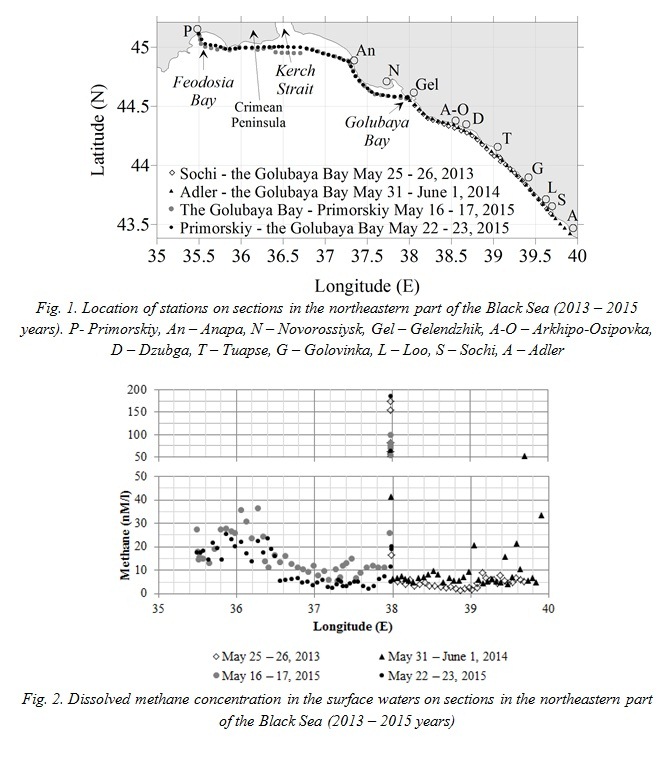
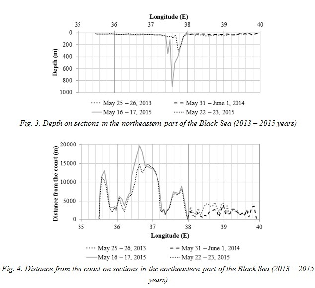
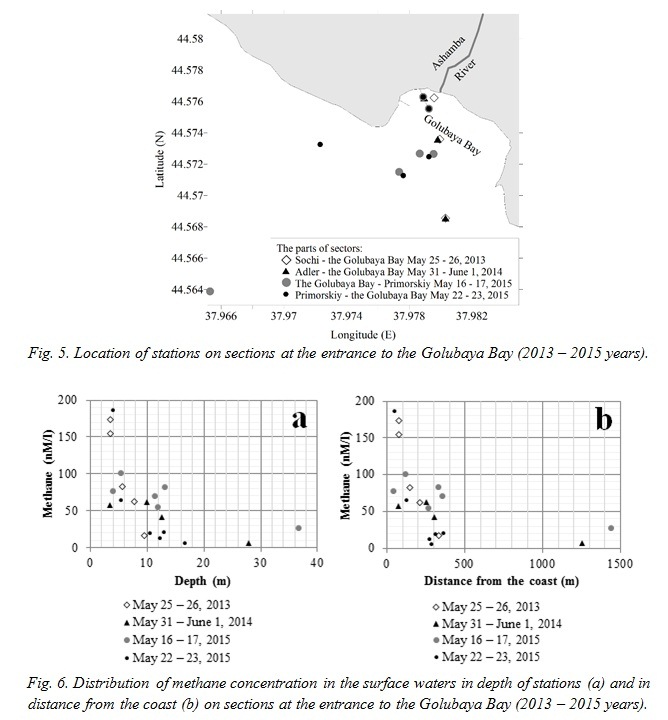
An array of values of methane concentrations obtained on sections along the coast may be divided into two parts, eastern and western, with approximate boundary on 36,5° E (Fig. 1, 2). Methane saturation to the east of 36,5° E is characterized by uneven distribution with local deviations from average value of 7,35 nM/l and generally not exceeding 10 nM/l. Depth in this site is 12 – 51 m in the main, distance from the coast is of 2500 m on average without exceeding 5000 m (Fig. 3, 4). The eastern part of the section May 16 – 17, 2015 differs in this area: average methane concentration is 10,65 nM/l, depth reaches 900 m, distance from the coast reaches 19600 m. Besides, there are several single peaks of methane concentration to the east of 39° E (15,87 – 53,27 nM/l).
In the site to the west of 36,5° E the quantity of dissolved CH4 increases to 36,31 nM/l on the first section in 2015 year (May 16 – 17) and to 25,50 nM/l on the second one (May 22 – 23), that is three times higher than concentrations of the eastern site. Average depth on the western area is 25 m (in the range 7 – 35 m) with considerably varied distance from the coast that reaches 14700 m.
Saturation of waters by dissolved methane increases exponentially from the open sea to the shore in the parts of sections at the entrance to the Golubaya Bay of Gelendzhik (Fig. 5, 6). The amplitude of values of CH4 concentration is 5,18 – 185,38 nM/l. Depth increases linearly with moving from the coast. The minimum registered value of methane quantity in this region is situated at station with the depth of 16,7 m at distance of 287 m from the shore while concentration at the most seaward station is 26,00 nM/l (depth is 36,7 m, distance from the coast is 1441 m). The maximum methane concentration is registered at station of 51 m away from the coast and with depth of 4,0 m. According to the data of 2015 year, methane saturation in the mouth of the Ashamba River that flows to the Golubaya Bay is 303,20 nM/l May, 16 and 830,91 nM/l May, 23.
Meteorological conditions during the study period and several days before sampling were analyzed. Winds of eastern rhumbs and speeds of 2 m/s prevailed on sections May, 25 – 26, 2013 and May 31 – June 1, 2014. Light rain and drizzle were registered on section in 2014 year at night from May 31 to June 1 near Tuapse. During two days before sampling on the first section in 2015 year there was sustained southern wind with speed of 10 m/s. During the study period May 16 – 17, 2015 wind direction was southwestern, average wind speed was 3 m/s with intensification to 7 m/s at night May 16. Since May 19, 2015 wind direction in this area was changed to northeastern with speed about 6 m/s that was gradually decreased to 2 m/s until the end of working May 23.
In order to estimate the coastal and bottom effect on quantity of dissolved methane, the correlation coefficients of methane concentration with depth and distance from the coast were calculated. In the Table 1 these values are presented separately for each section without entrance to the Golubaya Bay and excluding an area between 37,4° and 38,0° E where depth reaches 900 m and there is no correlation. Also the coefficient general for four sections is calculated for area with entrance to the Golubaya Bay.
Table 1. Correlation coefficients of methane concentration in the surface waters with depth and distance from the coast on sections in northeastern part of the Black Sea in 2013 – 2015 years.
|
Study site |
Average depth, m |
Correlation coefficient of methane concentration with depth |
Average distance from the coast, m |
Correlation coefficient of methane concentration with distance from the coast |
|
Sochi – the Golubaya Bay of Gelendzhik May 25 – 26, 2013 |
34,9 |
-0,6 |
2659 |
-0,5 |
|
Adler – the Golubaya Bay May 31 – June 1, 2014 |
24,4 |
-0,5 |
1830 |
-0,4 |
|
The Golubaya Bay – Primorskiy May 16 – 17, 2015 (except area 37,4 – 38,0° E) |
27,8 |
-0,5 |
8632 |
-0,5 |
|
Primorskiy – the Golubaya Bay May 22 – 23, 2015 (except area 37,4 – 38,0° E) |
25,8 |
-0,7 |
7582 |
-0,5 |
|
Parts of sections with entrance to the Golubaya Bay (2013 – 2015 years) |
10,9 |
-0,6 |
319 |
-0,5 |
V. Discussion and Conclusions
Since observations in 2013, 2014 and 2015 years are coincided with each other in season (the end of May – the beginning of June), we suppose that seasonal variability of methane saturation in water affects insignificantly general situation in comparison with other factors that will be considered below. About third of study territory, namely an area of the southeastern shelf of the Crimean Peninsula (Fig. 1), is characterized by rather high methane saturation in the surface waters (Fig. 2). Apparently, it caused by the strong effect of external factor. It is important that the field of heightened concentrations of CH4 is situated in a zone of influence of the Azov Sea stream through the Kerch Strait in this case. This advection along with increased industrial and transport load is considered as one of significant sources of contamination of the water area in the eastern Crimea [12]. The Azov Sea is subjected to intense freshening due to continental runoff of the Don and the Kuban Rivers. On the other hand, it is known that increased content of dissolved methane is typical for mouth areas of rivers [13, 14]. CH4 concentration peaks around the Crimean Peninsula were registered on longitude 36,3° E (36,31 nM/l, section May 16 – 17, 2015) and 35,8° E (25,50 nM/l, section May 22 – 23, 2015), i.e. to the west of the Kerch Strait. The similar maxima of methane concentration were observed in study [2]. Under the influence of the Rim Current of the Black Sea, having cyclonic direction, and the Coriolis force waters of the Azov Sea move westward after overcoming the strait. Apparently the Azov water flow, which is significantly freshened and enriched by organic matter, causes increased saturation of waters of the Black Sea around the Crimea by dissolved methane.
One of the factors of heightened CH4 concentration in the northeastern part of the Black Sea is bottom sources. Thus, according to [15], the Taman-Anapa shelf is characterized by presence of gas showings. In particular, relation between maximum of methane concentration in the surface waters of the Anapa shelf and bottom gas source at a depth of 35 m was found [2]. Furthermore, a lot of gas emissions located deeper than 85 m were detected in the Kerch-Taman area since 1990. Sites of gas discharge were identified on continental slope with the upper limit of spread at 200 m to the south of the Feodosia Bay since 2007. And it was shown that methane may reach the surface waters from the bottom sites at depth above 250 m [8]. According to the data of the 65th research cruise of the RV “Professor Vodyanitskiy” (July – August, 2010) in the northeastern part of the Black Sea, a large number of single gas plumes and its congestion at depth of 79 – 900 m, which were located in the shelf edge inflection zone, the upper and the middle parts of the continental slope, were found [16], gas plumes were detected since 30 m and deeper as well [17]. Within our investigations water sampling was carried out in the areas with a depth not exceeding 50 m. Observed stations with maxima of CH4 concentration in the surface waters to the southeast of the Crimean Peninsula are situated close to gas emissions registered in [17] (Fig. 2, 7). In addition, there is information about supposed mud volcanoes on the Kerch-Taman shelf, according to atlas [18], and intense showings of hydrocarbon gases from the bowel to the water column at a depth of 20 – 40 m in 1976 [19]. Thus, bottom gas showings can also be attributed to potential factors that increase methane saturation in waters.
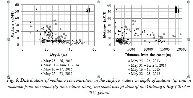
According to analysis of data observed on sections along the coast in the northeastern part of the Black Sea (except area with entrance to the Golubaya Bay), there is inverse correlation of methane quantity in the surface waters with depth of stations (-0,5 - -0,7) and with distance from the coast (-0,4 - -0,5) (Table 1). Plots of methane concentration versus depth and distance from the coast also illustrate this relation (Fig. 8). Distribution patterns of values on the plots vary for northern and southern sections due to big difference of depth and distance from the coast. However, increase of methane concentration is observed generally approaching the shore and with decreasing depth. Evidently, the result obtained indicates an influence of coastal factors on dissolved methane saturation increase. The local surface maximum of concentration in 5000 – 6000 m from the shore at depth of 25 – 30 m (Fig. 8) do not fit the relation described above, apparently, it can be explained by location of stations in area affected by the Azov Sea waters and bottom gas emissions.
This relation is more obvious on sites of sections with entrance to the Golubaya Bay (normal to the coast) where it is exponential (Fig. 5, 6). Correlation coefficients of methane concentration with depth and distance from the coast in this area are -0,6 and -0,5, respectively (Table 1). Besides, the Ashamba River, which flows into the Golubaya Bay, impacts considerably on increasing methane concentration in the bay because of high concentration in the mouth.
Single maxima of methane concentration occurred on the sections along the coast (most frequently on the section Adler – the Golubaya Bay May 31 – June 1, 2014) are situated around inhabited localities as Sochi, Loo, Golovinka, Tuapse (Fig. 1, 2). However, values and locations of these maxima vary for each section. Apparently, heightened methane concentrations are caused by the influence of continental runoff and anthropogenic pressure in this case. Wind speed during the study period was relatively low, so its influence on the methane concentration pattern was insignificant. On the other hand, activity of mesoscale eddies in this area could affect the formation of the particular methane distribution pattern in the surface waters.
Thus, presented study shows that the Azov Sea flow spreading in the research area is the significant factor of heightened methane saturation in the surface waters to the west of the Kerch Strait. At the same time, bottom gas emissions are the potential source of increased methane concentration here. An important result of the conducted measurements is the identification of inverse correlation of methane concentration in the surface water with depth and distance from the coast. Applied aspect for the study region is the fact that the local maxima of CH4 concentration in coastal waters in many cases are related with continental runoff and anthropogenic pressure.
VI. Acknowledgement
The field observations were supported by the Russian Science Foundation, Project 14-50-00095. The laboratory investigations and data analysis were funded by the Russian Foundation for Basic Research, Project 16-35-00156 mol_a.
1. V.O. Horoshevskaya “Patterns of formation and distribution of methane in the coastal waters of the Azov-Black Sea basin,” extended abstract of PhD dissertation. Southern Federal University, Rostov-on-Don, 2010. (in Russian)
2. A.V. Egorov, L.I. Lobkovskiy, S.A. Kovachev, et al. “Methane anomaly in the waters of Anapa shelf and its possible relation to oil-and-gas bearing structures,” Oceanology, 2008, vol. 48, no. 1, pp. 68 - 76.
3. N.M. Bazhin “Methane in the atmosphere,” Sorosovskij obrazovatel'nyj zhurnal [Soros Educational Journal], 2000, vol. 6, no. 3, pp. 52 - 57. (in Russian)
4. A.Yu. Lein, M.V. Ivanov “The largest methane reservoir on the Earth,” Priroda [Nature], 2005, no. 2, pp. 19 - 20. (in Russian)
5. O.K. Bordovskiy, V.N. Ivanenkov “Vol. 1. Chemistry of oceanic waters,” Okeanologija. Himija okeana [Oceanology. Ocean chemistry]. Moscow, Nauka, 1979, 518 p. (in Russian)
6. P. Dimitrov, V. Dachev, H. Nikolov, D. Parlichev “Natural gas seepages in the offshore area of Balchik Bay,” Okeanologija [Oceanology], no. 4, pp. 43-49. (in Bulgarian)
7. D. Amouroux, G. Roberts, S. Rapsomanikis, M. O. Andreae “Biogenic gas (CH4, N2O, DMS) emission to the atmosphere from near-shore and shelf waters of the north-western Black Sea,” Estuarine, Coastal and Shelf Science, 2002, vol. 54, no. 3, pp. 575 - 587.
8. V.N. Egorov, Yu.G. Artemov, S.B. Gulin Metanovye sipy v Chernom more: sredoobrazujushchaja i ekologicheskaja rol' [The methane seeps in the Black Sea: environment-forming and ecological role]. Sevastopol, NPC “EKOSI-Gidrofizika”, 2011, 405 p. (in Russian)
9. I.I. Rusanov, A.Yu. Lein, N.V. Pimenov, S.K. Yusupov, M.V. Ivanov “The biogeochemical cycle of methane on the northwestern shelf of the Black Sea,” Microbiology, 2002, vol. 71, no. 4, pp. 558 - 566.
10. O.K. Bordovskiy, A.M. Chernyakova Sovremennye metody gidrohimicheskih issledovanij okeana [Modern methods of ocean hydrochemical investigations]. Moscow, P.P. Shirshov Institute of Oceanology AS USSR, 1992, 201 p. (in Russian)
11. A.M. Bolshakov, A.V. Egorov “Methods of study of the gas composition of samples of water and bottom sediments,” Izuchenije gazovogo sostava osadkov [The study of the gas composition of sediments], 1987, pp. 248 - 251. (in Russian)
12. P.D. Lomakin, A.I. Chepyzhenko, A.A. Chepyzhenko “Estimation of the concentration of dissolved oil products in coastal waters of the Crimea based on optical measurements,” Ekologicheskaja bezopasnost’ pribrezhnoj i shel’fovoj zon i kompleksnye issledovanija resursov shel’fa [Ecological safety of coastal and shelf zones and complex investigations of shelf resources]. Sevastopol, NPC “EKOSI-Gidrofizika”, 2006, no. 14, pp. 245 - 258. (in Russian)
13. M.A. De Angelis, M.D. Lilley “Methane in surface waters of Oregon estuaries and rivers,” Limnology and Oceanography, 1987, vol. 32, no. 3, pp. 716 - 722.
14. Yu.A. Fedorov, N.S. Tambieva, D.N. Garkusha, V.O. Horoshevskaya Metan v vodnyh ekosistemah [Methane in water ecosystems]. Rostov-on-Don - Moscow, Rostizdat, 2005, 329 p. (in Russian)
15. K.M. Shimkus, V.N. Moskalenko, W.B.F. Ryan, W.C. Pitman III “Gas-bearing Quaternary sediments of the Kerch area of the Black Sea shelf and their relation with the coastal lithofacies,” Bjulleten' Moskovskogo obshchestva ispytatelej prirody, otdelenie geologii [Bulletin of the Moscow Society of Naturalists, Department of Geology], 1998, vol. 73, no. 4, pp. 51 - 55. (in Russian)
16. E.F. Shnyukov, V.A. Emelyanov, A.S. Kuznetsov, T.S. Kukovskaya, A.A. Shchiptsov “Geological and geochemical studies in the 65th cruise of the RV "Professor Vodyanitskiy" in the Black Sea (July-August 2010),” Geologija i poleznye iskopaemye Mirovogo okeana [Geology and mineral resources of the World Ocean], 2010, no. 3, pp. 94 - 98. (in Russian)
17. E.F. Shnyukov, A.A. Pasynkov, A.A. Lyubitskiy, Yu.I. Inozemtsev, E.N. Rybak, A.S. Kuznetsov “Mud volcanoes on the Kerch area of shelf and slope of the Black Sea,” Geologija i poleznye iskopaemye Mirovogo okeana [Geology and mineral resources of the World Ocean], 2010, no. 3, pp. 28 - 36. (in Russian)
18. E.F. Shnyukov, Yu.V. Sobolevskiy, G.I. Gnatenko, P.I. Naumenko, V.A. Kutniy Grjazevye vulkany Kerchensko-Tamanskoj oblasti: Atlas [Mud volcanoes of the Kerch-Taman region: Atlas]. Kiev, Naukova Dumka, 1986, 152 p. (in Russian)
19. R.P. Kruglyakova, M.V. Kruglyakova, N.T. Shevtsova “Geological and geochemical characteristics of natural hydrocarbon showings in the Black Sea,” Geologija i poleznye iskopaemye Mirovogo okeana [Geology and mineral resources of the World Ocean], 2009, no. 1, pp. 37 - 51. (in Russian)