


с 24.11.2017 по настоящее время
с 24.12.2017 по настоящее время
с 25.11.2017 по настоящее время
с 26.12.2017 по настоящее время
BISAC NAT010000 Ecology
BISAC NAT045050 Ecosystems & Habitats / Coastal Regions & Shorelines
BISAC NAT025000 Ecosystems & Habitats / Oceans & Seas
BISAC NAT045030 Ecosystems & Habitats / Polar Regions
BISAC SCI081000 Earth Sciences / Hydrology
BISAC SCI092000 Global Warming & Climate Change
BISAC SCI020000 Life Sciences / Ecology
BISAC SCI039000 Life Sciences / Marine Biology
BISAC SOC053000 Regional Studies
BISAC TEC060000 Marine & Naval
The article analyzes the data of expedition studies conducted by the team of the leading scientific school of Professor Fedorov Yu.A. in the Archangelsk region for more then 10-years period of researches. The materials of mercury content obtained for samples of bottom sediments sampled in the mouth area of the Northern Dvina River, the lakes of Arkhangelsk and the surrounding areas, at Dvina Bay and different areas of the White Sea. Based on the available data and having considered the results of the authors working on the subject of mercury pollution in the subarctic region, conclusions about the level of anthropogenic impact on water bodies and streams of the Arkhangelsk region are justified. Factors that contribute to the formation of relatively high and low concentrations of mercury in sediments identified. The effects of mechanical, hydrochemical, hydrological barriers analyzed. The natural background of mercury in the bottom sediments of the region revealed. Comparative analysis of the accumulation of mercury in the bottom sediments of the study area and other parts of the subarctic region realized. Opportunities and conditions for existence of the effect of "secondary pollution" discussed.
bottom sediments, coastal areas, Arkhangelsk region, mercury pollution
I. Introduction
The peculiarity of bottom sediments is their ability to sequestrate mercury and its compounds and in the case of changing physicochemical and hydrodynamic environmental conditions to bring them partly back to the water column. This results in repeated water pollution, which can last for many years. Generally, the most toxic mercury forms are released from bottom sediments. Such events nonplus the ecologists, as against the background of the all-in-all trouble-free state of the aquatic environment and absence of visible pollution sources one observes the bursts of very high concentrations of mercury and its compounds. As the Northern Dvina estuarine area refers to the bodies, for which mercury is an element of characteristic pollutants [1-3], the urgency is obvious to study the changes in content of this metal and its compounds in the bottom sediments in the region as a factor that can have an adverse effect on the surface water quality. It should be also added that such long-term and large-scale mercury measurements from the bottom sediment area and depth are done for the first time.
Mercury remains one of the priority pollutants of the environment, and this fact concerned the international community. So, at January 19, 2013, after four years of negotiations, parties to the UN was agreed a new international instrument on the issue of mercury contamination of the environment, which aims to reduce the use of mercury in industry, as well as the elimination of accumulated mercury-containing waste [4].
Lake ecosystems are systems with standing or slightly flowing waters. Bottom sediments, formed in these conditions, are able to demonstrate the timing of the formation of anthropogenic pollution and its intensity. That is, to act as an indicator of anthropogenic load. At the same time, because of its features, lake ecosystems are more vulnerable to various types of exposure. Research has shown that the presence of only one activity on the lake – a recreational, can cause increased toxicity of water and bottom sediments from the complete lack of prior chronic toxicity in short time – 10 years [5].
Bottom sediments of rivers and other watercourses have greater mobility. In estuarine and tidal areas of rivers bottom sediments are affected also by such factors as changing salinity, pH, Eh and other physico-chemical characteristics along with the hydrodynamic factor.
The mouth region of the Northern Dvina River inflowing into the White Sea is a marginal filter in which anthropogenic factors play important roles equally with the natural factors and processes. The marginal filters are the first step in the removal of pollutants off the waters entering with riverine discharge [6].
Major work on the study of sediment on the content of mercury, on the basis of which this article is written, has been held in the mouth area of the Northern Dvina River.
River sections as subject waste water discharges and relatively little susceptible to human impacts (the top of pre-estuarial area) were investigated. Also was conducted testing of lake bottom sediments adjacent to the territory of the Arkhangelsk agglomeration, bottom sediments of Ilas marshes and different parts of the White Sea.
II. Methods OF COLLECTION, PREPARATION, AND ANALYSIS OF samples
Several expeditions were organized and realized on the rivers and water reservoirs of northern part of European territory of Russia in 2004–2011 to study the peculiarities of changes in mercury content in water and bottom sediments by the staff of Southern Federal University. The study regions encompassed the mouth region of the Northern Dvina River, Dvina Bay, and the White Sea areas [7-9]. The procedures of sampling, sample processing and determination of mercury content in the bottom sediments followed the methods tested earlier in the Russian waterbodies [3, 7, 8].
The bottom sediments were sampled along the river in the mouth region with a bottom scoop and/or a tube of a State Oceanographic Institute design aboard the R/V “Aisberg2” in the surface (0–5-cm depth) and subsurface (5–10 cm) sediment layers. More than 150 samples of river bottom sediments were taken at 18 monitoring stations (the scheme of sampling stations see in [3]).
And in the open part of the White Sea bottom sediments were sampled aboard the R/V Professor Shtokman (64th cruise; August, 2004) by the staff of the Shirshov Institute of Oceanology, Russian Academy of Sciences [9]. The number of analyses totaled more than 350 including 170 analyses of the surface layer of sediments (depth of 0–5 cm).
During the field research a series of lakes, namely Lake Korziha, Lake Butygino, Ilas Marshes, Lake Kudmozero, Lake Kholmovskoye, Lake Lakhta, backwater of Solombalka were investigated (Fig. 1). From each water object differing on physical and chemical composition of waters, bottom sediments and samples of water were collected at randomly selected littoral (<
Most mercury measurements were performed with the help of an atomic absorption method in the cold vapor of the certified Laboratory of the Southern Federal University. The frequency control of the results obtained was performed in the Federal State Unitary Geological Enterprise (FSUGE) Yuzhgeologiya and Hydrochemical Institute of Roshydromet. The measurement error was 10–15%. Eh and pH were also measured in bottom sediments. Accuracy of the analysis also confirmed that analysis was performed of the analyst Anikanov A.M. He was took part in an international intercalibration experiment for determination of mercury in standard water samples, the laboratory held AMOS-Proficiency Test, Water Analysis. On the accuracy of determinations performed 30 laboratories from around the world, his findings did not come from the interval of permissible error values.
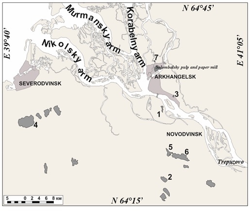
Fig. 1. Schematic map of investigated lakes. 1 - Lake Korziha, 2 - Ilas Marshes, 3 - Lake Butygino, 4 - Lake Kudmozero, 5 - Lake Lakhta, 6 - Lake Kholmovskoye, 7 - backwater of Solombalka.
III. RESULTS AND DISCUSSION
Mercury concentration in bottom sediments of the estuarine area of the Northern Dvina River and the Dvina Gulf of the White Sea varied within 0.02–0.80 μg/g dry weight (DW) amounting on average to 0.135 μg/g DW [3, 7]. Very high mercury concentrations were detected in bottom sediments of internal channels crossing the town of Arkhangelsk. It should be said that these values were excluded from average concentration calculations. Changes in mercury concentration by levels were as follows. In the 0–5-cm layer the mercury content varied from 0.02 to 0.48 μg/g DW, on average it amounted to 0.11 μg/g DW; in the 5–10-cm layer the minimum content was 0.02 μg/g DW, the maximum content was 0.8, the average content was 0.16 μg/g DW.
In the top of the pre-estuarial area of the Northern Dvina River, mercury concentration changed in a narrow interval of values and approached the minimum (0.04–0.05 μg/g DW). At the Port Bakaritsa station, 51 km away from the sea edge of the delta, mercury content in the bottom sediments reached comparatively high values (up to 0.37 μg/g DW). At the next station, downstream of the delta, the mercury concentration decreases approximately by 10 times accounting for 0.03 μg/g DW. The mercury content in the bottom sediment of the Solombala Island station increased up to 0.2 μg/g DW. When moving along Maimaksa channel, over the bottom sediment area from the station Port Ekonomiya to the Mud'yugskii Island station, mercury concentration increases from 0.05 to 0.18–0.22 μg/g DW.
The study of the spatial distribution of mercury in bottom sediments of the estuarine water area showed the following features. The bottom sediments in the water area are the most polluted being influenced by the town of Novodvinsk with the largest pulp-and-paper plant in the region, the Kuznechikha channel downstream of the mouth of the Yuras River and the dock of Solombala Island. The area of the enhanced mercury concentration in bottom sediments is detected in the zone where river waters mix with the sea waters; it stretches from the station of Ust’yanskie turning gange lines to the station of Mud’yugskii Island. When passing a complex barrier formed in the zone where river and sea waters mix, which is mostly pronounced near the station of village of Lapominka, mercury is intensively removed from the water solution being absorbed by suspended substance and then deposited [11-13]. Mud’yugskii Island is a mechanic barrier on the way of river waters moving forward. Here, the water flow velocities decrease and fine disperse suspended material mostly enriched in mercury deposits [3, 13-15]. Such mechanism can also promote accumulation of mercury and its compounds in bottom sediments in the region under the influence of the town of Novodvinsk. Numerous small islands and shoals located over this section of the stream channel play the role of a mechanic barrier. Thus, natural conditions together with the anthropogenic factor promote here the formation of bottom sediments with the maximum metal concentration.
Investigations of accumulation of mercury in the upper layers of lake bottom sediments in the Arctic shows [16] that concentration of mercury in these layers for a hundred years increased from 0.03 to 0.11 μg/g. In Russia the strongest pollution is observed near iron and steel works on the Kola Peninsula and in Norilsk where the corresponding concentration exceed background levels of tens, and in some places in hundreds of times.
The amount of mercury in time not only increases in lakes, but also in marine sediments. Even at the North Pole in the sediments at depths from 22 to
In general at the bottom sediments of the Archangelsk region lakes, the total mercury contents varied from 0.002 to 0.052 μg/g DW (mean 0.012 μg/g DW). The highest concentration of mercury detected in the bottom sediments in the backwater of Solombalka, amount of 0.04 μg/g DW. Relatively high concentrations were found in bottom sediments of the Ilas marshes (varied from 0.009 to 0.06, in average 0.026 μg/g DW).
At the same time, high concentrations of mercury in the backwater of Solombalka allow us to conclude that the main role in the accumulation of mercury here are the effluents of industrial and agricultural enterprises and ports, located on the Northern Dvina River. Backwater of Solombalka has a direct relationship with the Northern Dvina river, as Solombalka is it’s channel.
In the case of bottom sediments of the Ilas marshes, where the mercury contamination was in average 2 times higher than in bottom sediments of lakes in the region – we can talk about the role of organic matter as a supplier of mercury and pH, namely the acidity that increase the mobility of mercury in all components of the landscape.
Overall features of the distribution and accumulation of mercury in bottom sediments of rivers and lakes in the region indicates a small role of the transport of mercury into water bodies through atmospheric channel compared to the direct impact on aquatic ecosystems. Perhaps some role in the uptake of atmospheric mercury can play the vegetation of the region. So, researchers have detected elevated mercury concentrations in the spruce needles and lichens on woody vegetation in the vicinity of sources of mercury emissions to the atmosphere [17].
Distribution of mercury in bottom sediments of lakes by depth revealed insignificant fluctuations of concentration with a maximum content of mercury in horizon from 2.0 to 4.0 cm with a further decrease with depth.
By analyzing the distribution of mercury in depth of the sediment, it is important to take into the sedimentation rate of sediments. The rate of sedimentation in lakes depends on many factors, such as efficiency of aquatic ecosystems, structure of soils and breeds of a reservoir, susceptibility of economic activity, and the amount of flowing streams. Thus, for each concrete lake will apply its rate of sedimentation. According to various authors, the rate of sedimentation of the lake in the test region fluctuate within 1.6 -
Study of mercury content in deep-water areas of the White Sea allowed to reveal that concentrations of mercury in the bottom sediments of the White Sea varied in the range 0.006–0.095, averaging 0.023 μg/g DW. Note that about 80% of the samples contain less than 0.03 µg/g DW of mercury [21].
The authors studied the column of bottom sediments from the White Sea, came to the following conclusions: changes of concentrations of mercury is unequal with general tendency to decrease with depth; the maximum concentrations are confined to the horizon of 1.5–3.0 cm sediment; for the upper horizon 0.0–1.5 cm is characterized by the presence of low concentrations of mercury, there is a zone of erosion of sediments, oxidation and a sharp lower border; the presence of the second peak concentrations at depths of 7.5–10.0 cm (2.5 times less compared to the upper horizon), due to the high content of iron sulfides here.
Variations of natural background concentrations of mercury were defined in the range of 0.01–0.03 μg/g DW. At the same time over a background value for the ecosystem of the White Sea was suggested to adopt the upper limit of this range, that is 0.03 μg/g DW [21].
To evaluate the contamination of bottom sediments by the aquatic ecosystems of Arkhangelsk region, it was decided to use the methodology of determining the index of ecological danger of Hakanson [22], adapted for conditions in the European subarctic.
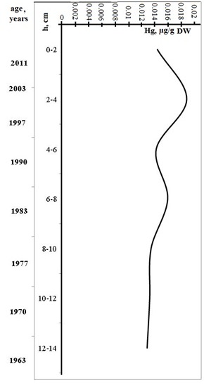
Fig. 2 Average mercury content in bottom sediments of the Arkhangelsk region lakes and the years of their formation (quoted from the article [23]).
The contamination factor was calculated as the quotient of the concentration of the substance in the surface layer of bottom sediments to pre-industrial background value (1). To determine background values was analyzed available data. For bottom sediments of lakes of the Arkhangelsk region revealed average mercury content at the level of 0.012 µg/g DW. For the lakes of the Kola Peninsula these values are on a comparable level [24]. Thus, the proposed value of the background concentration of mercury in bottom sediments of lakes was equal to 0.012 µg/g DW.
Cz=C0-2/Cb (1)
C0-2 - Hg concentrations in the upper horizon of bottom sediments
Cb - background value.
Contamination factor for lakes bottom sediments: Cz =1,25
for Northern Dvina estuarial bottom sediments: Cz = 3,45
for White Sea bottom sediments: Cz = 1,24
for Ilas Marshes bottom sediments: Cz = 1,68
So, ranking at a rate of the ecological index danger revealed that bottom sediments of the river ecosystem is most subjected to anthropogenic change and pollution of mercury, while bottom sediments of the Arkhangelsk Region lakes and the White Sea bottom sediments have a little transformed regarding mercury pollution, an intermediate position is occupied by bottom sediments of the Ilas Marshes.
IV. Conclusion
The study of bottom sediments and it’s mercury contamination we can make the following conclusions.
The mercury content in bottom sediments of lakes of Arkhangelsk region varies from 0.002 to 0.052 μg/g DW, with an average 0.012 μg/g DW. Relatively high concentrations were found in bottom sediments of the Ilas marshes (varied from 0.009 to 0.06, in average 0.026 μg/g DW). Concentrations of mercury in the bottom sediments of the White Sea varied in the range 0.006–0.095, averaging 0.023 μg/g DW. Mercury concentration in bottom sediments of the estuarine area of the Northern Dvina River and the Dvina Gulf of the White Sea varied within 0.02–0.80 μg/g dry weight (DW)amounting on average to 0.135 μg/g DW.
The levels of Hg concentrations in the studied lakes are comparable with values for lakes of the Kola Peninsula, not subject to the direct influence of wastewater of industrial enterprises, 4-25 times lower concentrations of mercury in the bottom sediments of lakes of the North American continent. In average the highest concentrations of mercury from different lakes were found in bottom sediments in the backwater of Solombalka, it was 0.04 μg/g DW. At the same time, high concentrations of mercury in the backwater of Solombalka allow us to conclude that the main role in the accumulation of mercury here are the effluents of industrial and agricultural enterprises and ports, located on the Northern Dvina River.
In comparison with bottom sediments of Northern Dvina, where mean of total mercury contamination in bottom sediments is 0.14 μg/g DW, lake bottom sediments contain up to 12 times smaller amount of mercury. These features can be explained by the fact that the lakes are not affected of mercury with wastewater, the main brings of metal and its compounds occurs due to atmospheric transfer and also washout of mercury-containing connections from a reservoir surface. And as we can see their role in the transportation of mercury is small.
Due to the very significant accumulation of mercury in bottom sediments of the estuarine zone of the river, we can assume that under certain conditions, it is possible emission of mercury from the sediments into the water column, and its inclusion in biogeochemical cycles. This danger is relevant to the area of the river, which located downstream from city Novodvinsk. Also in the study of mercury contamination in bottom sediments, we can observe the work of the marginal filter, through which the main part of the migrating in the water mercury is deposited in the mixing zone of the Northern Dvina river - Dvina Bay of the White sea.
V. Acknowledgment
The work was supported by the President Grant MK-6241.2016.5, and G/k № 1334.
1. Olenicheva A. V. “About the Experience of the Northern Administration of Hydrometeorological Service (NAHS) in the Field of Studying Extremely Polluted Regions of the Natural Environment,” in The NAHS Information Letter No. 1 (164) (Severnoye UGMS, Arkhangel'sk, 1997) [in Russian].
2. Ovanesyanc, A.M., Krasil'nikova, T.A., Ivanov, A. About the pollution of the environment and radiation situation in the Russian Federation in March 2008 [O zagrjaznenii prirodnoj sredy i radiacionnoj obstanovke na territorii Rossijskoj Federacii v marte 2008 g.]. Meteorologija i gidrologija, 2008, no 6, pp. 98-104.
3. Ovsepyan A.E., Fedorov Yu.A. Mercury in the mouth area of the Northern Dvina river [Rtut' v ust'evoy oblasti reki Severnaya Dvina]. Rostov-on-Don -Moscow: ZAO "Rostizdat", 2011. 198 p.
4. Minamata Convention on Mercury [Minamatskaya konventsiya o rtuti]. URL: http://mercuryconvention.org/Portals/11/documents/Booklets/Minamata_convention_Russian.pdf (accessedApril24, 2016)
5. Bakaeva E.N., Ignatova N.A. Dynamics of toxic water and bottom sediments of recreation water bodies [Dinamika toksichnosti vod I donnyh otlozheniy vodnogo ob’ekta rekreatsii] // Sovremennye problemy nauki i obrazovaniya № 6, 2011. URL: http://www.science-education.ru/ru/article/view?id=4997
6. Lisitsyn A. P. “Marginal Filter of Oceans,” Okeanologiya, No. 5, 34 (1994) [Oceanology, No. 5, 34 (1994)].
7. Fedorov Yu. A., Ovsepyan A. E., Korobov V. B., and Dotsenko I. V. Bottom Sediments and Their Role in Surface Water Pollution with Mercury (with a Special Reference to the Northern Dvina River Mouth and the Dvina Bay of the White Sea), Russian Meteorology and Hydrology, Vol. 35, No. 9, Pp. 611-618, 2010.
8. Fedorov Yu.A., Ovsepyan A. E. Chapter 8: Mercury and Its Connection with Physicochemical Water Parameters (Case Study of the Rivers of the Northern European territory of Russia), p.155-172 in the Book Mercury: Sources, Applications and Health Impacts, Published by Nova Science // Ki-Hyun Kim Richard J. C. Broun Editors, Published by Nova Science publishers. Inc. New York. USA. 2013. 264 p.
9. Fedorov Yu.A., Ovsepyan A.E., Lisitsyn A.P. i dr. Patterns of mercury distribution in bottom sediments along the Northern Dvina river - White Sea section [Zakonomernosti raspredeleniya rtuti v donnykh otlozheniyakh po razrezu reka Severnaya Dvina - Beloe more]. Doklady Akademii nauk, 2011, vol. 436, no 1, pp. 99-102.
10. Fedorov Yu.A., Ovsepyan A.E., Korobov V.B. Pecularities of mercury distribution, migration and transformation in the estuarine area of the Northern Dvina River [Osobennosti raspredeleniya, migratsii i transformatsii rtuti v vodakh ust'evoy oblasti r. Severnaya Dvina]. Meteorologiya i gidrologiya, 2010, no 4, pp. 85-92.
11. Skibinskii L. E. The Role of Geochemical Barriers and Geochemical Barrier Zones in Forming of the Hydrochemical Regime of Coastal Waters of the Arctic Seas // Proceedings of the XII Congress of the Russian Geographical Society (St. Petersburg, 2005), Vol. 5.
12. Shevchenko V. P., A. Yu. Bogunov, A. A. Lebedev, et. al., “Systematic Studies of Suspended Substances in the Marginal Filter of the Northern Dvina River in the Late Winter Period,” in Materials of the All-Russian Conference with International Participation “Academic Science and Its Role in Developing Production Forces in the Northern Regions of Russia,” CD-ROM (Arkhangel'sk, IEPS, UrO RAN, 2006) [Institute of Ecological Problems in the North, Ural Division, Russian Academy of Sciences, 2006].
13. Moor J. and S. Ramamurti, Heavy Metals in Natural Waters (Mir, Moscow, 1987) [in Russian].
14. Ovsepyan A. E. and Yu. A. Fedorov, “On Some Peculiarities of Mercury Distribution in the Northern Dvina Estuarine Bottom Sediments,” in Geology, Mineral Deposits, and Geoecology of the Russian Northwest. Materials of the XVII Youth Scientific Conference Dedicated to K.O. Kratts' Memory (Izd. KarNTs RAN, Petrozavodsk, 2006) [in Russian].
15. Opekunov A. Yu. “Aqual Technosedimentogenesis,” Trudy VNIIIOkeangeologii Ministerstva Prirodnykh Resursov RF, Vol. 208 (Trans. All-Russian Research Institute of Ocean Geology, Department of Natural Resources of the Russian Federation, Nauka, St. Petersburg, 2005) [in Russian].
16. AMAP Assessment 2002: Heavy Metals in the Arctic. Arctic Monitoring and Assessment Programme (AMAP) report, Oslo., 265 P., 2005.
17. Tarkhanov S.N. Conifer plantations in conditions of atmospheric pollution [Khvoynye nasazhdeniya v usloviyakh atmosfernogo zagryazneniya]. Lesnoe khozyaystvo, 2004, no 3, pp. 18-20.
18. Routh, Joyanto; Meyers, Philip A.; Hjorth, Tomas; et al. Sedimentary geochemical record of recent environmental changes around Lake Middle Marviken, Sweden. Journal of Paleolimnology. V. 37. Issue 4. P. 529-545
19. Sternbeck J., Ostlund P. Metals in sediments from the Stocholm region: geographical pollution patterns and time trends // Water, Air, & Soil Pollution: Focus. 2001. V. 1. № 3-4. P. 151-165.
20. Subetto D.A., Shevchenko V.P., Lisitsyn A.P., Ludikova A.V., Kuznetsov D.D., Sapelko T.V., Evzerov V.Ya., Van Beek P., Souhaut M., Subetto G.D. Chronology of isolation of the Solovetskii archipelago lakes and current rates of lake sedimentation, Doklady Earth Sciences, Vol. 446., № 1, pp 1042-1048, 2012.
21. Fedorov Yu. A., Ovsepyan A.E., Savitskiy V.A. Distribution of mercury in the bottom sediments of the White Sea // Zhivye i biokosnye sistemy. - 2013. - №2; URL: http://www.jbks.ru/archive/issue-2/article-8.
22. Håkanson L. An ecological risk index for aquatic pollution control - a sedimentological approach. Water Researches, v.14, p.975-1001, 1980.
23. Ovsepyan A.E., Fedorov Y.A., Zimovets A.A., Savitsky V.A. Features of accumulation of mercury in the bottom sediments of lakes in Arkhangelsk and its surrounding area. International Multidisciplinary Scientific GeoConference Surveying Geology and Mining Ecology Management, SGEM 15th, Albena, Bulgaria 2015, pp. 353-360.
24. Dauvalter V.A. Сoncentrations of chalkophilous elements (Hg, Cd, Pb and As) in sediments of water reservoirs of the White Sea watershed within the Kola Peninsula // The study, sustainable use and conservation of natural resources of the White Sea. Proceedings of the IXth International Conference, October, 11-14, 2004. Petrozavodsk, Karelia, Russia. Petrozavodsk, pp. 92-96, 2005.