


с 25.12.2017 по настоящее время
с 26.12.2017 по настоящее время
с 26.12.2017 по настоящее время
с 26.12.2017 по настоящее время
с 26.12.2017 по настоящее время
с 26.12.2016 по настоящее время
BISAC NAT010000 Ecology
BISAC NAT045050 Ecosystems & Habitats / Coastal Regions & Shorelines
BISAC NAT025000 Ecosystems & Habitats / Oceans & Seas
BISAC NAT045030 Ecosystems & Habitats / Polar Regions
BISAC SCI081000 Earth Sciences / Hydrology
BISAC SCI092000 Global Warming & Climate Change
BISAC SCI020000 Life Sciences / Ecology
BISAC SCI039000 Life Sciences / Marine Biology
BISAC SOC053000 Regional Studies
BISAC TEC060000 Marine & Naval
This study is aimed at developing of an operational oceanographic system for the Russian sector in the Gulf of Finland and South-Eastern part of the Baltic Sea for operational forecast of hydrodynamic and ecosystem parameters on the basis of high and ultra-high spatial resolution models. The system is presented as a complex of regional and local models; for which a coupled modeling integration at boundary conditions exchange is fulfilled. The models share common mathematical formulation of general motion equations and a unified realization on the basis of programme code modeling modules designed for the ocean modeling – NEMO. The regional model of the Baltic Sea circulation is complemented by a module for the inert matter transport simulation. The latter is set up on the basis of a matter turbulent diffusion model with the use of two consistent equation systems: deterministic and stochastic. The designed operational system consists of two subsystems: operational oceanographic system of the coastal areas of the Baltic Sea and an expert-analytical system of operational monitoring of the aquatic environment and effective response to accidents at sea.
Baltic Sea, coastal zones, hydrodynamic model, operational forecast, matter transport, expert-analytical system, operational monitoring
I. INTRODUCTION
Today the operational oceanography in the region of the Baltic and
Spatial resolution of the models used for operational forecasting of the
In RSHU the operational oceanographic system has been developed that is aimed at producing the 3-D hydrophysical fields (current velocities, sea level, water temperature and salinity, concentration and thickness of ice cover) in the Russian water area: the Eastern part of the
II. SYSTEM DISCRIPTION
NEMO is a 3-D hydrostatic, baroclinic primitive equation model written in nonlinear orthogonal coordinate system implying the existence of confluence areas of the computational grid. Equation approximation is produced on the Arakawa C-grid (Madec et al., 1998; Madec, 2012). Vertical coordinate system is realized in two versions: z* and hybrid coordinate. NEMO is being developed in a framework of a community of European institutes and thus benefits of the recent scientific and technical developments implemented in most ocean modelling platforms. The NEMO implementation for the
For the
The calculation domain covers the entire Gulf of Finland including the
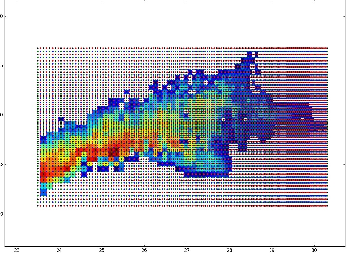
Figure 1 – Scheme of the calculation domain (bathymetry and grid points). One cell corresponds to 10 grid cells.
When the local hydrothermodynamic model of the Kaliningrad Shelf has been developed the following key geophysical features of the modeled object has been considered: bathymetry, drift circulation, coastal upwellings and downwellings, vortex dynamics. The baroclinic radius of deformation according to the estimates presented in Golenko M. N. & Golenko H.H 2011 is
Boundary conditions for the two local models are delivered by the NEMO-Nordic model (Hordoir et al., 2015), jointly developed by SMHI, FMI and RSHU and realized for the Baltic Sea and part of the
In this project the daily computational fields of the HIRLAM model (High Resolution Limited Area Model) with spatial resolution of
An integral part of any operational oceanographic system is the procedure of observational data assimilation. In the considered OOSB the three-dimensional variation assimilation scheme (3D-VAR) stated by Dobricic S. and Pinardi N. (2008) is used for this purpose.
Here both assimilation of remote sensing (satellite SST and altimetry), and of contact measurement data is possible (data on water temperature and salinity from buoy stations, data from drifters).
Data assimilation is a cyclic procedure according to the scheme "analysis-forecast". At the analysis step in each cycle all observations in a certain (assimilation) time window are acquired. The assimilation procedure allows to produce predictive cycles of the operational system presented at figure 2.2. A predictive cycle is 48 hours, with the forecast updating every 12 hours by starting the forecast from a new initial field. So the assimilation window is 24 hours, thus, every second forecast starts with an analysis field corrected by the assimilation procedure. Data of observations during the assimilation window (24 hours) are considered as instantaneous.
Unlike the basic assimilation cycle, there is also an additional periodic assimilation cycle covering 10 "past" time assimilation windows. Use of the additional cycle is due to the fact that part of observational data comes with a delay or, as in a case with satellite altimetry, is periodically updated as presented at figure 2. In this case the cycle forecast-assimilation-analysis is done all over again (every 12 hours with the moving assimilation window of 24 hours within 10 days) to obtain a new analysis field taking into account observational data for the past 10 days.
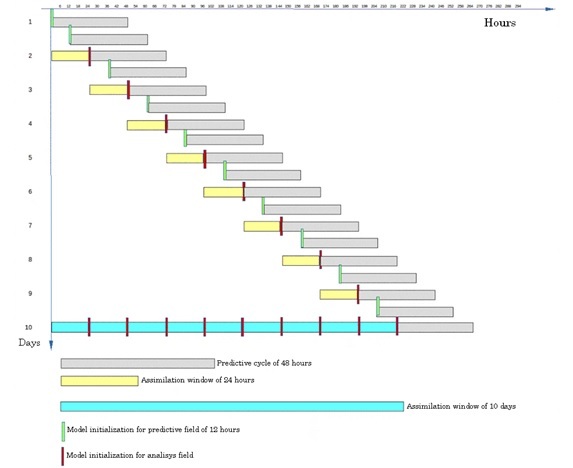
Figure 2. – Operational system predictive cycles.
Also as a part of the operational system there is an expert and analytical system of operational control of the state of the study water area and of fast emergency response to marine accidents. The main aim of the expert and analytical system is to organize remote automated workplaces for an observer – hydrometeorologist. The automated workplace of observer - hydrometeorologist can be used for operational analysis of various options of environmental impact on the basis of a numerical model of admixture distribution remotely started on the main server and adapted for various options of emergency actions.
The basis of the expert and analytical system is the admixture transfer model formulated in the Lagrangian coordinates. Initial data for it are the predictive fields automatically delivered by the operational oceanographic system (surface current velocities, diffusion coefficients), and location and volume of emission set by the user. On the basis of data on current velocities the ensemble of possible trajectories of passive admixture is calculated.
III. CONCLUSION
The study considers the operational oceanographic system developed for the Russian sector of the Baltic Sea: the
IV. Acknowledgments
This work was supported by the Federal Target Programme for Research and Development in Priority Areas of Development of the Russian Scientific and Technological Complex for 2014–2020 (Identification No.: RFMEFI57414X0091).
1. Alenius, P., Nekrasov, A., and Myrberg, K.: The baroclinic Rossby-radius in the Gulf of Finland, Cont. Shelf Res., 23, 563-573, 2003.
2. Golenko M.N., Golenko N.N. Effects of entrainment and vorticity at wind-driven coastal upwelling and downwelling for the South-Eastern Baltic // Aerokosmicheskie issledovaniya, prikladnaya mekhanika, TRUDY MFTI, 2011, 3(3), 56-63
3. Dobricic S, Pinardi N. An oceanographic three-dimensional variational data assimilation scheme // Ocean Modelling. 2008. V.22. P.89-105.
4. Hordoir, R., Schimanke, S., Axell, L., et al.\ 2015, EGU General Assembly Conference Abstracts, 17, 12657
5. Madec, G., Delecluse, P., Imbard, M., and Levy, C.: OPA 8.1 Ocean General Circulation Model reference manual. Note du Pole de modelisation, Institut Pierre-Simon Laplace (IPSL), Paris, France, No 11, 91 p., 1998.
6. Madec, G.: NEMO ocean engine. Note du Pôle de modélisation, Institut Pierre-Simon Laplace (IPSL), Paris, France, No 27 ISSN No 1288-1619, 2012.
7. Soomere T., Quak E. Preventive methods for coastal protection: Towards the use of ocean dynamics for pollution control / Eds. Springer. 2013. 442 p