


BISAC NAT010000 Ecology
BISAC NAT045050 Ecosystems & Habitats / Coastal Regions & Shorelines
BISAC NAT025000 Ecosystems & Habitats / Oceans & Seas
BISAC NAT045030 Ecosystems & Habitats / Polar Regions
BISAC SCI081000 Earth Sciences / Hydrology
BISAC SCI092000 Global Warming & Climate Change
BISAC SCI020000 Life Sciences / Ecology
BISAC SCI039000 Life Sciences / Marine Biology
BISAC SOC053000 Regional Studies
BISAC TEC060000 Marine & Naval
The work is devoted to geoecological assessment of dangerous natural processes development for the Black and Azov seas coasts within the Taman peninsula. Special consideration has given to a factor of tectonic instability for the region. By the example of the events has shown that this factor must stay at first place during geoecological risk assessment.
Taman peninsula, geoecological risk, seacoasts, Black sea, Azov sea
- . Introduction
Intensive economic development of the Black and Azov seas coastal zone requires the solution of the important geoecological tasks. Typically, geoecological risk assessment includes the quantification of damage from the impact of the waves and landslide processes, floods and surges of floodwaters, man-caused operations. This assessment is undertaken for the purpose of developing of preventive measures to reduce the impact of named processes to the transformation of the coastal zone.
Long-term monitoring of the Taman Peninsula coastal zone showed that these estimates of the geoecological risk are not sufficient to solve the problems of interaction between the region's ecosystems and population. The geological structure of Peninsula is too complex. Tectonic instability of the earth strata in the region may lead to unpredictable consequences. The aim of investigations became the assessment of the conditions of dangerous natural processes development within the Taman Peninsula by the degree of severity of geo-ecological risk.
II. Field investigations
Object and subject of research
The focus of investigation became the Taman Peninsula coastal zone. In geotectonics, Taman Peninsula is a heterogeneous formation, located at the junction of mountain ranges of the Crimea and the Caucasus. This is what has determined the allocation of several major tectonic structures of the first order in the region. These are joint meganticlinoriums of the Mountainous Crimea and the greater Caucasus, Indolo-Kuban trough, Kerch-Taman transverse deflection [1]. Active of tectonic processes contributes to additional erosion of the coastline, as well as the creation of conditions of emergency in some settlements of the coastal strip.
The state of geological structures of Taman region has characterized as stress-strain. Increasing load of stress exceeding the rock strength, may lead to a "disrupt" of the pinched together wings of the seismogenic fault and to the subsequent earthquake. According to the elastic-rebound theory of earthquakes [2], "...after "disrupt" of the seismogenic fault wings and subsequent earthquake requires some time interval to accumulate new stresses which can exceed the long-term strength of rocks and to cause another violation of the connectivity of the array...". The interval between earthquakes, referred to as an indicator of "maturing" of the earthquake, is a stable value for a regional rate of tectonic motions (when the additional factors of external influence are absent). The main subject of investigations became the searches for the most vulnerable the peninsula coasts with high population density and evaluation of earthquakes "maturing" indicators for those places.
Methods and data
The research data been obtained during field experiments throughout the period 2008 – 2016 years. The research has carried out by the method of displaying of natural processes signs. The samples of soil, water and breccias been taken for the laboratory analyses. During the field investigation was used the high-precision equipment (navigational, radiometric instruments and labware), licensed mapping software with the topographic data. Have been selected the publications of previous years relating to the geological structure of the region, the speeds of abrasion processes of the coastal strip, the existence of extraordinary geologic events.
Results
The Taman peninsula coastline length is 230 km approximately. Abrasion, abrasion-landslide and abrasion-falling destruction of coastal structures cover 60 km (26%) of the seacoasts (Fig. 1). 30 km (13%) of this shore type is placed along of the Azov sea (from the Peresyp to the village of Ilyich). 30 km (13%) – along of the Black sea (from the Taman to Veselovka).
The average speed of the shore breakdown for the listed type of destruction is 1.0-1.5 m/year, maximum – 4.0-6.0 m/year. Abrasion-falling type of shore is characteristic for loamy and clay structures. These structures have elevated the abrasion rate (1.8-2.5 m/year). This type of shore was fixed along the coastal line of the Azov sea (Fig 1). Abrasion-landslide shore exists where presence the sandy sediments. This type of shore is usual for the marked on Fig. 1 the Black sea coastline. This structure has abrasion rate about 0.5-0.6 m/year.
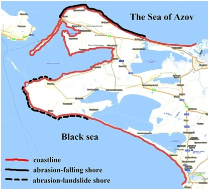
Fig. 1. Taman peninsula
Additionally, the increased retreat rate of the shore of Azov sea connected with high repeatability of winds of northeast direction (Fig. 2).
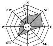
Fig. 2. The frequency of occurrence (%) of wind directions and calms (in the circle) over the Taman peninsula
In Fig. 3 and Fig. 4 are shown abrasion-falling and abrasion-landslide coastal structures for mentioned above shores types of the Black and Azov seas.
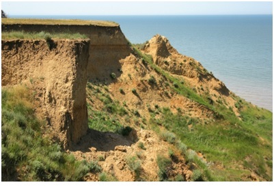
Fig. 3. Abrasion-falling coastal structure at the Azov seashore
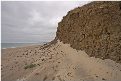
Fig. 4. Abrasion-landslide shore near the village of Veselovka.
Zoning of the Taman Peninsula coastal zone concerning abrasion processes have been performed repeatedly previously [3]. In this work, zoning is given only for submission of the coasts, which are characterized by high-speed abrasion. If in potentially hazard areas of the coastal zone will arise anomalies associated with the tectonic instability of the earth's strata, consequences of these impacts to the environment will increase significantly. The examples of events the past years are demonstrating the dangers of such anomalies.
Natural anomaly No. 1
During the night of 29 to 30 April 2011, in the area of Kamennyi cape has happened neotectonic lifting of the bottom the Sea of Azov, with the capture of the shoreline. Surface area of the raising amounted to 10 ha, approximately. The amplitude of uplifting was more than 5 m in relation to sea level [4]. The observations showed, that the rise of the seabed caused by the deformation of anticlinal folds, so far as the elevation was formed from bedrock. The rocks have undergone significant deformation and outcropped on the surface of the elevation under the angle to 800. Fields of breccias ejection been visualized in the places of naked seabed (Fig. 5).
Of the apparent eruption of a mud volcano on the surface of land not happened. Perhaps, reason for this is because the volcano crater is placed under water, on distance of 400 m from the shore, and the main eruption occurred there. However, we do not exclude the version: the big eruption never came. Under water have taken place some emissions of the mud volcanic products, and at the periphery of the crater (on the shore) occurred deformation of bedrock, local emission of mud and gas breakthrough.
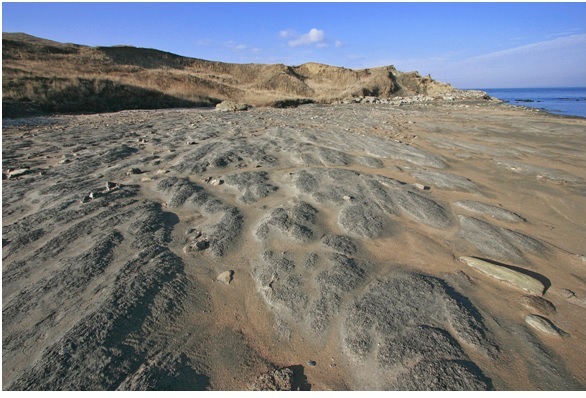
Fig. 5. Fields of breccias ejection in the places of naked seabed
In the immediate vicinity from the place of happened events situated the village. In Fig. 6 is shown situation plan for the moment of event.
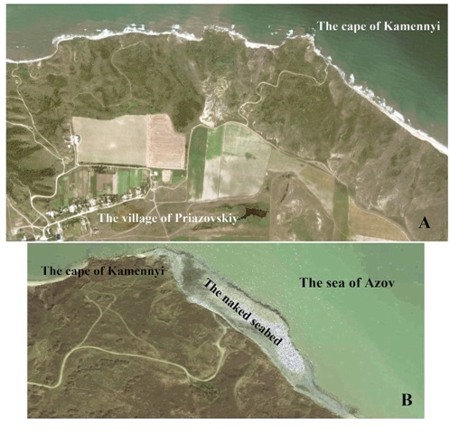
Fig. 6. The situation plan for neotectonic lifting:
A – a satellite view before 29.04.2011; B – a satellite view after 29.04.2011.
In the process of field investigations was carried out the monitoring of the uplifted area. Changing of the cape elevations relative to sea level were recorded in during 3 years. Result of monitoring presents in Fig. 7. The figure shows, the North-Taman microplate a rate of subsidence varied from 3 to 25 cm per month during the monitoring.
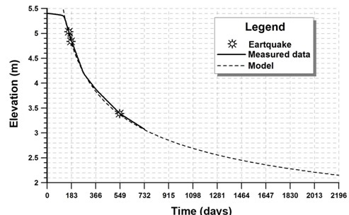
Fig. 7. Elevation changes of Kamennyi cape over a sea surface: data of monitoring and mathematical model.
Approximating of monitoring data has allowed mathematical derivation of changing the elevation over a sea surface. The equation looks like (1).
ln(Y) = - 0.3228030356 ln(61X/2) + 2.146247748 (1)
Here are: Y - an elevation over a sea surface, metre; X - time, day.
The plate a rate of subsidence is easy to calculate. According to this model, the plate will return to its original level after 37 years.
This suggests that using the calculated lapse of time the voltage of the contacting plates reaches a critical level and will be close to the long-term strength of rocks. Any outside influence would disrupt the connectivity of the arrays and lead to the next of nature's anomaly. In other words possible to say that the indicator of "maturation" of earthquake is 35-40 years for the anticline of the cape Kamennyi. Next critical level will be reached to the year 2048.
Our findings indirectly confirmed the residents of the Priazovskiy village, which is located near the cape Kamennyi. According to them, the same event happened in the same place 37 years ago, in 1974.
What reasons could (and might) lead to a "disrupt" of the pinched together wings of the seismogenic fault? Several individuals in the scientific community skeptically perceived the proposed hypothesis. The essence of the hypothesis was as follows. As the result of the resonance processes that have been arisen as an echo of the Tohoku earthquake (famous as earthquake of Fukushima), in the Taman region took place discharge of tectonic stresses, which were on the ultimate strength of rocks. Deformation of the anticlinal fold has revealed in the form of described anomaly. The main criticism was in next. Is too long distance separates the epicenter of the earthquake and the Taman region. We asked for the help to the "United States Centre for monitoring of earthquakes" [5]. The resulting materials gave us a full picture of the distribution of seismic vibrations across the globe during the process of the Tohoku earthquake.
Types of seismic waves and the seismograms at different points presents in Fig. 8.
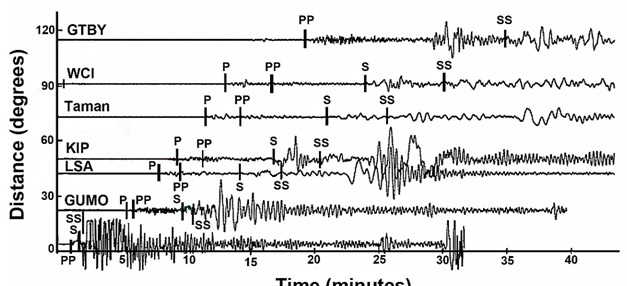
Fig. 8. The seismograms at different points of Earth and the types of seismic waves.
P, S – waves inside of Earth’s surface (the original, direct waves); PP, SS – added reflections at the underside of Earth’s surface. Data from [5].
The seismograms show, waves which first of all came to the Taman region, were waves moving inside of Earth's surface. These waves have reached to Taman region in 12 minutes after the start of the earthquake. Surface waves have achieved the Taman region in 37 minutes after the start of the earthquake. The diagrams of seismic wave’s propagation toward the Taman peninsulas after the earthquake start have shown in Fig. 9.
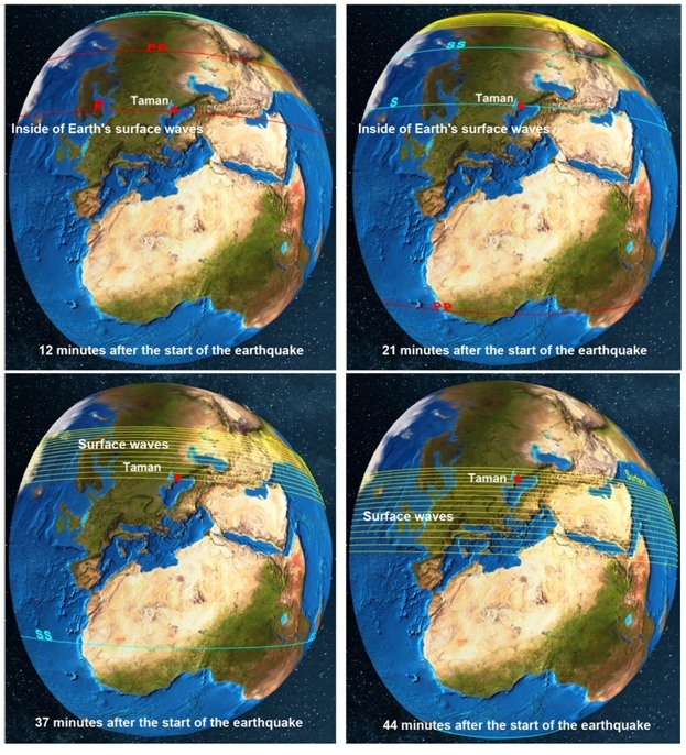
Fig. 9. The diagrams of seismic wave’s propagation toward the Taman peninsulas after the earthquake start.
The maximum amplitude of the oscillations of the Earth's surface in the Taman region exceeded background in 70 times [6].
The observations data for the processes of propagation of the Earth's surface oscillations when a catastrophic earthquakes show that unreachable points on the Earth does not exist. Seismograms show that significant exceeding (two orders) vibrations of the Earth's surface relative to the background, possible, initiated the Taman region events.
Natural anomaly No. 2
Another dramatic example of an event repeated with alarming frequency. Every 7-8 years within a village of Golubitskaya (in the sea) is happening eruption of a mud volcano. In 1908, the mud volcano eruption happened at the land. Now it is Caldera. It filled with water and mud. In 2000, the mud volcano eruption happened in the sea, about 300 m from the shore. An island formed in the process of volcano eruption. In June 2008, the mud volcano eruption happened about 100 m from the shore. An island has formed again. New the mud volcano eruption happened on October 25, 2015. A new formed island was much larger than island has formed after previous mud eruption. The places of named volcano eruptions have shown in Fig. 10.
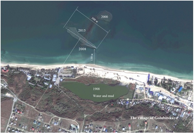
Fig. 10. The position of known mud volcano eruptions, from 1908 till 2015.
What is possible to say about an anomaly No. 2? The tectonic stresses' discharge frequency for Golubitskaya region is 6-8 years. Next mud volcano eruption is possible to wait about year 2023. Fig. 10 shows, the place of volcano eruption is not stable. It migrates from one eruption to another. There is a possibility it can displaced to the direction of the village. Also important is the factor of intensive radon emission during the eruption. Measurements, made in year 2011 at the cape of Kamennyi, showed an excess of radon concentrations relative to the background in 800 times. 97% of the radon will decay only 20 days after eruption. All this time populations will be at increased radiation exposure.
Fragments of volcano eruptions have shown in Fig. 11A, Fig. 11C and Fig. 11D. Also in Fig. 11B and Fig. 11E are displayed islands, have been formed after each volcanic eruption.
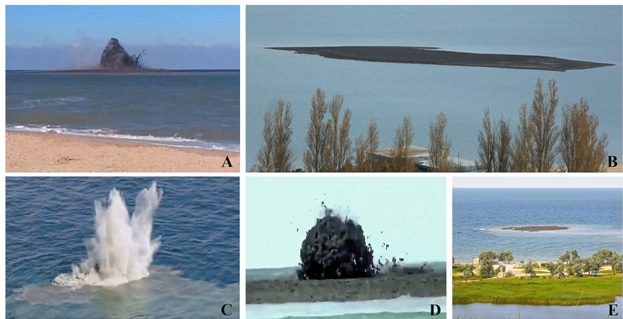
Fig. 11. Here are fragments of volcano eruption. In addition, islands, formed after each eruption. A – October 25, 2015; B – December 05, 2015; C, D – June 2008; E – July 01, 2008.
As has been said, the state of geological structures of Taman region has characterized as “stress-strain”. The article gives only the most vivid events of recent years. To consider in detail all potentially dangerous situations for the peninsula is quite difficult. In Fig. 12 shows the locations of the possible expressions of dangerous natural events related to tectonic processes. The catastrophic events, occurring in any place of the globe, may to disrupt the "fragile stability".
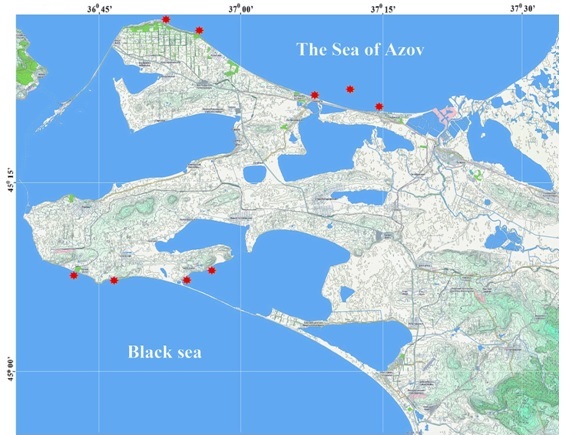
Fig. 12. Potentially dangerous places at the region of Taman peninsula.
III. Conclusions
The newly formed structures, emergent as result of discharge tectonic stresses, are indicators of the potential danger of a complex geological structure of the earth strata in the region.
Estimation the degree of geo-ecological risk of natural processes is the paramount importance. Factor of the region tectonic instability should be included in geoenvironmental risk evaluation.
Results of investigations may take into account when designing of sustainable development of Azov and Black seas' coasts within the Taman peninsula, during construction of shore installations and in other economic activities.
IV. Acknowledgment
Researches accomplished under the financial support of the Russian Scientific Foundation, project No 14-17-00547.
1. E.F Shnyukov, V.M. Sheremetiev, N.A. Maslakov, V.A. Kutniy, B.N. Gusakov, V.V. Trofimov, “Mud volcanoes of Kerch-Taman region,” Krasnodar: GlavMedia, 2006, 176 p. [in Russian].
2. H.F. Reid, “The elastic-rebound theory of earthquakes,” University of California Publ. Geol. Sci, no. 6, pp. 413-444, 1911.
3. D.G. Matishov, O.V. Ivlieva, P.P. Ivlieva, L.A. Bespalova, V.V. Sorokina, “Modern speed of abrasion and condition of shore protection structures the Russian coast of the Azov sea,” Proceedings of SSC RAS, vol. 1, Rostov: SSC, 2006, pp. 151-164 [in Russian].
4. I.S. Podymov, T.M. Podymova, “Anomalous Natural Phenomenon at the Coastal Zone of Azov Sea,” Global Congress on ICM. Lessons Learned to Address New Challenges. Proceedings of EMECS 10 Medcoast 2013 Joint Conference, Ankara, Turkey: Bizim Dijital Matbaa, 2013, vol. 1, pp. 655-664.
5. “The USArray GMV for M 8.9 Near East Coast of Honshu, Japan,” http://www.ds.iris.edu/spud/gmv/4841
6. “Signal to noise ratio map for all BHZ data at IRIS 0.3 to 1.0 Hz,” http://www.ds.iris.edu/spud/eventplot/650555