


BISAC NAT010000 Ecology
BISAC NAT045050 Ecosystems & Habitats / Coastal Regions & Shorelines
BISAC NAT025000 Ecosystems & Habitats / Oceans & Seas
BISAC NAT045030 Ecosystems & Habitats / Polar Regions
BISAC SCI081000 Earth Sciences / Hydrology
BISAC SCI092000 Global Warming & Climate Change
BISAC SCI020000 Life Sciences / Ecology
BISAC SCI039000 Life Sciences / Marine Biology
BISAC SOC053000 Regional Studies
BISAC TEC060000 Marine & Naval
For the first time, the quantitative characteristics of the Vistula Spit shore dynamics based on the ground-based monitoring data for 2002-2015 were presented. On the sea shore, 3 sections can be distinguished by the direction of coastal processes, i.e. the stable section to the north of the Strait of Baltiysk, the eroded 4-km section to the south of the Strait of Baltiysk, with maximum erosion rate up to 2 m/year; in the remaining area of the Spit (21 km) to the Polish border there is an alternation of stable, eroded and accumulative areas. Since 2011, a steady erosion (in the stable segments of the third section) and general weakening of the erosion rate (in the second section) have been recorded. 50% of the length of the lagoon shore was the subject to annual active erosion (0.2 - 1.4 m/year). The beaches of the sea and lagoon shores of the Vistula Spit were mainly composed of medium sands. The alongshore variability in particle size distribution on the sea and lagoon shores (according to the 2015 survey data) actually fail to correlate with long-term dynamic processes, with the exception of the steadily eroded 4-kilometer area on the sea coast to the south of the Strait of Baltiysk. Variations in the composition of sediment along the shore on the shoreline are most likely associated with the results of the latest wave processing (or storm processing and eolian transport in the case of an average beach sample).
Coastal dynamics, monitoring, coastal sediments, Vistula Spit, Baltic Sea.
I. Introduсtion
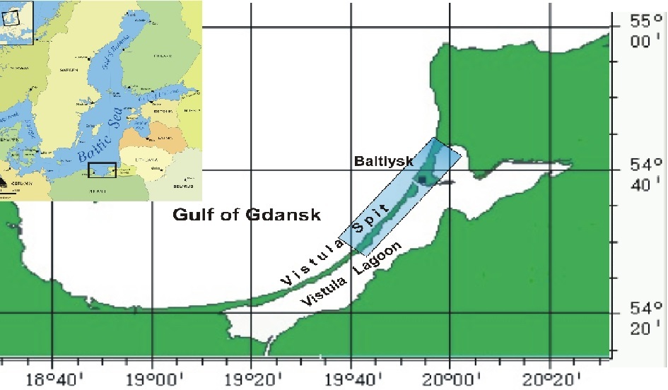
The Vistula Spit with a length of 65 km (the Russian part is 25 km, and it is 35 km taking into account the 10-km section to the north of the Strait of Baltiysk[1]) stretches from the southern end of the Kaliningrad (Sambian) Peninsula and south-west it is adjacent to the bedrock coast of Poland (Fig. 1.). It is a polygenetic depositional feature, a barrier spit that separates the Vistula Lagoon from the Baltic Sea [1].
The Spit was created as a result of the Holocene transgression [2, 3], it took the present shape after the creation of the Strait in 1510, which in the scientific literature, according to [4], is called Strait of Baltiysk. The Spit relief is mainly represented by the generation of uneven-aged forms of wind deposition accruing from the sea [5]. The shores are mainly composed of loose sand, and on the lagoon shore there are the ancient lagoon sediment outputs.
The south-eastern Baltic region is dominated by the west quarter winds, for winds > 5 m/s: SW – 27.4%, W – 37.8%, NW – 22.6% [4].
|
Fig. 1. The Vistula Spit (Russian part of the spit is marked by rectangular). From 1945 until the end of the 1990s of the last century the Spit shores were unavailable for research. Prior to coastal monitoring conducted by the AB IO RAS, in a similar way to findings for the Curonian Spit, it was believed that the shore of the Vistula Spit was eroded. The intensified coastal development, active man-induced intervention [6, 7], storm activity strengthening [8], raising the level of the Baltic Sea in the south-eastern Baltic region [9, 10, 11] and an uncontrolled increase in the anthropogenic load [12] created the need to evaluate the current state of the Vistula Spit shores, the direction and intensity of the coastal processes. The paper summarises the data for a 13-year period (2002-2015) of instrumental observations in comparison with the results of the first 5 years of that period. The data on the dynamics of the lagoon shore of the spit are presented for the first time.
II. Materials and methods The Russian part of the Vistula Spit shores was studied in the course of monitoring by AB IO RAS in the form of annual surveys by using geodetic profiling, lithological surveys, photographic and visual descriptions of the coast morphology features [13, 14]. Starting from 2002, monitoring has been conducted at 26 profiles (transects) on the sea shore (16 of them at the 5-km consistently erodible section south of the Strait of Baltiysk) and 14 on the lagoon coast on the coastal parts not covered by rooted vegetation (Fig. 1). During trigonometric levelling along the profile perpendicular to the shore line the following features of the vertical profile were recorded: the edge of the main foredune, its foot; the top or edge of the attached or embryonic foredune; the upper limit of the eolian rig (eolian cushions), the lower limit of eolian rig (terminology according to [15]); beach surface breaks, beach barrier, edge, submerged margin of the beach bench. Altitude profiles were built with Excel. As an indication of either erosion or coastal accretion (Fig. 2) a change in the distance horizontally from the mark to the dune crest or the edge of the eroded bench (if the shore is retreated) or to the top or line of the slope break of the embryonic foredune (for a stable coast or an accretion coast) [13].
|
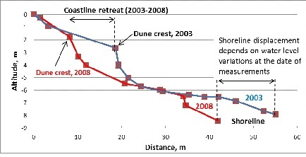
Fig. 2. Altitude profiles of 2003 and 2008 (at profile 7mv) on the eroding sea shore of the Vistula Spit. The beach retreated for 5 years at 11.2 m.
Levelling was performed with the use of high-precision surveying instruments, e.g. 3T5PK theodolite, Trimble GPS receivers (the base station L1 + 5700 mobile complex R3). In recent years, a tacheometer has been used.
Alongside with levelling on each profile to the following nose samples were collected from the sea beach, the beach average sample (starting with the shoreline and to eolian blowing) and the sample separately from the shoreline. Only the beach average sample was taken on the side of the lagoon.
In the cameral conditions, a grain size analysis of samples was carried out on the sieve analyser VP-30T by sieving through a series of sieves with a mesh of <10; 10~7; 7~5; 5~3; 3~2; 2~1; 1~0.5; 0.5~0.25; 0.25~0.1; <0.1 mm.
III. The Vistula Spit sea shore dynamics (2002-2015)
The first generalisation of observations of the morpholitodynamics of the Vistula Spit coast are presented in a number of papers [16, 17, 18, 19, 20, 21]. It has been found that the sea shore of the spit, except for the northern 5-kilometer section adjacent to the Strait, is mainly stable. In the middle of the Russian part of the spit there was a steady accumulation of sediments including the development of an embryonic foredune and extension of its edges of the beach (Fig. 3.)
An analysis of shore process observations for a 13-year period (2002-2015) has shown that a distinction can be made between three sections as far as directionality of shore processes is concerned (Fig. 3, Table 1). Section 1 (10 km, profiles 1ms-4ms) north of the Strait of Baltiysk is stable [18]. Section 2 is represented by a steadily eroded shore at 4 km south of the Strait of Baltiysk (profiles 7mv-1p,). Here, the most heavily eroded is the shore directly adjacent to the south pier, where for 13 years about 23 meters of the remaining fragments of the foredune and coastal platform (profiles 1p, 5p; retreat 2 m/year) have been washed away. On the shore section south the erosion was 10 m (profile 7mv; retreat 0.7 m/year). The maximum erosion per year (10 m) was recorded at the profile 7mv in 2005 after a strong winter storm. In recent years, the erosion has weakened in that area (Table 1).
Section 3 (profiles 1mv-6amv, 21 km) stretches southwest from section 2 to the Polish border and is characterised by alternating eroded, stable and accretion segments (Fig. 3, Table 1). For 13 years the maximum erosion value was recorded in the southern area (profile 1mv) near the Polish-Russian border, and it was 10 m (retreat - 0.8 m/year). Four more erosion segments were identified (profiles 3mv, 4mv, 5mv, 6amv), where the foredune retreated respectively at 7.7 m, 4 m, 3.6 m, 3.7 m (-0.8, -0.6, -0.3, -0.7 m/year). At the same time, especially in the middle part of the third section (profiles 2mv, 4amv, 5amv, 6mv), the accumulation processes were dominating. For example, on the profile 6mv the series of embryonic dunes advanced 15 meters towards the sea. The annual average values of the positive coastal dynamics were +0.08; +0.6; +2.0; +1.2 m/year respectively.
For 13 years of monitoring, a change in evolution of coastal processes at the southern end of the 3rd section of the spit was identified (Fig. 3). At the previously stable segment (profiles 1mv, 3mv, 4mv, 6аmv) in recent years, stable erosion has been recorded since 2011. For example, in an extreme storm in 2011-2012 at Rp.1mv 4.5 of the foredune was washed, Rp.3mv – 1.0 м, Rp.6аmv – 3.1 m. in the same storm near the southern breakwater, the erosion was maximal for the entire coast: Rp.1p – 6.7 м, Rp.7mv – 6.2 м [22]. At Section 2 a significant weakening of the abrasion rate can be seen for the whole period in comparison with the first 5 years (Table 1).
IV. The Vistula Spit lagoon shore dynamics (2002-2015)
The tortuous indentation of the spit from the bay is created by a number of alternating ridges and lagoon areas. The eroding land, slopes of the ancient dunes and coastal terraces, which make up about 50% of the length of the coastline, are interspersed with some sections of a stable shore confined to aquatic vegetation thickets [23. As few as two months ago, the shore is protected by ice from the wave effects. The rise and fall of the water level in the lagoon is developed with winds from the south to the north-eastern areas, for winds > 5 m/s: S – 16.2%, SE – 5.5%, E – 5.6%, NE – 2.7% [4].
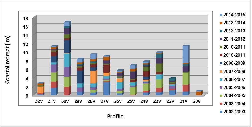
An analysis of monitoring data showed that the erosion value changes significantly from year to year and has been from 2.7 to 17 m for 13 years (Fig. 3). In most of the profiles the erosion value was 7-9 m. The erosion values vary considerably even for profiles that are close enough, the minimum erosion of 2.7 m was recorded at the 32v profile, and the maximum erosion at the 30v profile. The erosion values vary considerably and within individual local areas 32v-31v (by 4 times) and 30m-27v (nearly by 2 two time).
For most of the lagoon shores the erosion was more intense in 2002-2007 than in the following years, especially in the southern sector. For example, at 32v-31v site the average rates of retreat at the profiles in 2002-2007 (5 years) and 2002-2015 (13 years) were 0.4 and 0.2 m/year and 1.52 and 0.9 m/year respectively. The opposite situation was recorded only in the areas characterised by the profiles 21v, 28v (Table 1).
In terms of the annual average velocities, the rate of erosion of the lagoon shore of the Vistula Spit averages 0.4-0.8 m/year varying in the range of 0.2-1.4 m/year (Table 1). The erosion of the lagoon shore is of the selective nature, in different years, different parts of the shore are eroded with varying intensity (Fig. 4). It is not possible to use the data to register any patterns in the rates of erosion of the lagoon shore in terms of either time, or space.
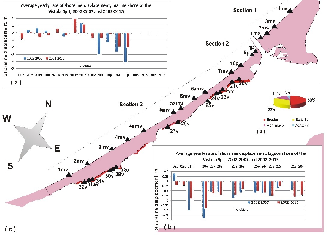
Fig. 3. The dynamics of the sea shore (а) and lagoon shore (b) of the Vistula Spit according to the data of annual monitoring surveys at fixed profiles (c) in 2002 – 2015, and types of shores on the lagoon side of the Vistula Spit (d).
|
Table 1. The average value (m/year) of the Vistula Spit shore displacement (2002-2015). “-“ means coastal retreat |
|||||||||||
|
Displacement of the Baltic Sea shore, m |
Displacement of the Vistula Lagoon shore, m |
||||||||||
|
No of profile |
2002-2015 |
2002-2007 |
No profile |
2002-2015 |
2002-2007 |
No of profile |
2002-2015 |
2002-2007 |
No profile |
2002-2015 |
2002-2007 |
|
1p |
-2.0 |
-4.1 |
5mv |
-0.3 |
-0.5 |
20v |
-0.69 |
- |
27v |
-0.69 |
-0.89 |
|
5p |
-1.9 |
-2.6 |
4amv |
+0.6 |
lost |
21v |
-0.81 |
-0.44 |
28v |
-0.7 |
-0.55 |
|
10p |
-0.14 |
-1.3 |
4mv |
-0.3 |
+0.3 |
22v |
-0.26 |
-0.37 |
29v |
-0.64 |
-0.54 |
|
7mv |
-0.7 |
-3.0 |
3mv |
-0.6 |
+0.7 |
23v |
-0.75 |
-0.76 |
30v |
-1.4 |
-1.93 |
|
6amv |
-0.74 |
lost |
2mv |
+0.1 |
+0.4 |
24v |
-0.6 |
-0.64 |
31v |
-0.9 |
-1.52 |
|
6mv |
+1.16 |
+1.4 |
1mv |
-0.8 |
0 |
25v |
-0.53 |
-0.6 |
31av |
-0.2 |
lost |
|
5amv |
+2.0 |
lost |
|
|
|
26v |
-0.42 |
-0.6 |
32v |
-0.2 |
-0.4 |
V. Fractional composition of beach sediments of the sea shore of the Vistula Spit
In 2015, in general, the composition of beach sediments repeated the previously obtained results [20, 21, 24]. In the seashore average beach samples taken in 2015, the fraction over 2 mm could be found only in samples at the 1st section while the 2nd and 3rd sections were dominated by the medium-grained sand (0.25-0.5 mm) accounting for 28 to 70 %, mainly 50-60 % (Fig. 5). At the shoreline the proportion of coarse sand (1-0.5 mm) was a bit bigger (Fig. 6), for example, at the profiles 4аmv, 5mv, 6amv, 7mv, 5p, 1p it was more than 50% (52 to 80%). At the profiles at 4 km eroding section the gravel and pebbles, which formed separate clusters in the form of strips in the near-shore swash zone, were found in the sediments.
With the exception of the northern eroded 4-km coastal area, no direct correspondence between the composition of sediment on the beach and shoreline and the coastal dynamics could be determined. Thus, the average beach samples in eroding areas (3mv, 4mv, 5mv) contain a larger proportion of the fine-grained sand than the sediments at the profiles 5amv and 6mv, where there is accumulation. The profiles 1mv and 7mv can be characterised by the same rate of erosion but the coarse sand content varies by 2 times (it is more at 7mv).
At the shoreline, as a part of the samples on profiles 1mv, 3mv, 4amv and 5mv, the proportion of the coarse fraction is consistently increasing, while the reduction in erosion rate is observed for them, even the material accumulation at 4amv.
At section 1 on the profile just outside the northern breakwater (1ms) a significant (over 40%) content of the fine-grained sand was found (Fig. 6) at the shoreline. In the north (2ms – 4ms) impurities contained a large volume of coarse sand (34 – 42%). On the same profiles the maximum content of the coarse fraction for the whole shore (72 to 90 %) was found in the average beach sample (Fig. 5). Although this section of the coast is perfectly stable by its morphometric parameters.
|
Fig. 4 . Dynamics of the lagoon shore of the Vistula Spit in 2002-2015 |
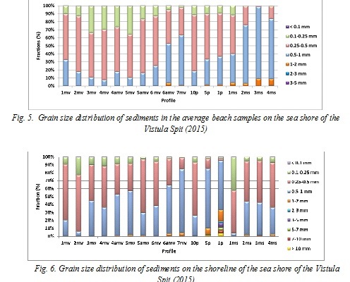
Thus, the fractional composition of sediments on the sea beach of the Vistula Spit (the beach average and on the edge) is correlated with the long-term shore dynamics only on the long eroding shore of the 4-kilometer stretch to the south of the Strait of Baltiysk.
Thus, the fractional composition of sediments of one year on the sea coast of the Vistula Spit (neither the beach average, nor on the shoreline) may not be a feature of the long-term shore dynamics. Variations in the sediment composition along the coast on the shoreline are most likely associated with the latest wave processing (or storm processing and the eolian transport in the case of the beach average sample).
VI. The Fractional Composition of Beach Sediments of the Vistula Spit Lagoon Shore
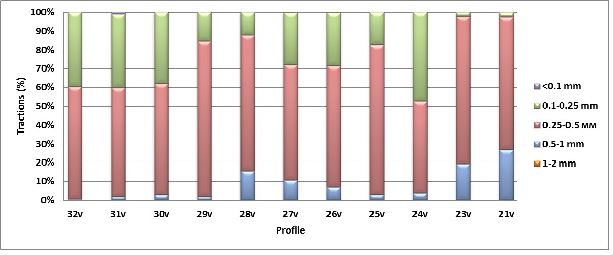
The beaches of the Vistula Spit are sandy from the lagoon side. Their width varies (up to 1-15 m) depending on the height of the standing water level in the lagoon. They are mainly created by the average-grained sand (49-82% of the sample quantity, Fig. 7) as well as on the sea shore but with a significant proportion of the fine-grained sand. Typically, there are no sediments larger than the ones.
|
Fig. 7. Grain size composition of beach sediments of the lagoon shore of the Vistula Spit as of 03 July 2015. |
On the lagoon shore there is no relation between the composition of sediment on the beach and the coastal dynamics either; e.g. at the section 32v-31v the composition of sediments is the same but the dynamics differ greatly. On the contrary, for profiles 29v, 28v, 27v, 23v, 21v the dynamics are virtually identical but the composition is significantly different.
VII. Conclusions
The developed comprehensive method of land-based shore monitoring made it possible to obtain objective data on the shore dynamics, the direction of the coastal processes at the shore of the Vistula Spit in 2002-2015 (compared to the five-year period 2002-2007). A significant drawback of the method is the point-based character of measurement. In the case of the presently significant spatial variability of morphodynamics the measurements at the profiles represent formally regular sampling but the random ones to represent the processes variability. However, the existing network is quite optimal to determine the evolution of coastal processes.
According to the dynamical conditions, the Vistula Spit seashore can be divided into three parts. Section 1 to the north of the Strait of Baltiysk (10 km) is stable. Section 2 (4 km south of the Strait of Baltiysk) is steadily eroded, the rates of erosion are maximal and reached 23 meters for 13 years (almost 2 m/year), and for the first 5 years of monitoring 2.5-4 m/year, in other words, the erosion rate slightly weakened. At Section 3 (21 km) there is an alternation of the stable and eroded areas. Since 2011 there has been a drastic change in the coastal processes in the southern part of the Section 3, the annual erosion has started. At the same time, in the middle part of Section 3, the accumulation is stable and has even intensified. Perhaps, the unloading of longshore sediment migration took place here for the indicated period.
On the lagoon side about 50% of the length of the coastline of the Vistula Spit accounts for the eroded coast. Retreat of the lagoon shore of the Spit could be seen annually in 2002-2015. In some years, the edges of the ancient dunes or terraces retreated at 4 m. Moreover, based on the projected future rise in level due to global warming, we should expect further strengthening of the lagoon shore erosion.
In general, the 2015 survey results found no direct correlation between the sediment composition on the beach and shoreline and the long-term coastal dynamics from the sea and lagoon sides of the spit. Variations in the composition of sediment along the coast on the shoreline are most likely associated with the results of the latest wave processing (or storm processing and eolian transport in the case of the beach). The exception is the 4-kilometer consistently eroded section of the sea shore to the south of the Strait of Baltiysk.
The composition of the sediment from the sea and beach sides of the Spit is very similar, it is dominated by medium-grained sands. On the lagoon shore there are no beach sediments larger than the sandy ones.
VIII. Acknowledgement
The monitoring results reported in the paper were summarised in the framework of the Russian Science Foundation Project No 14-17-00547 “A forecast development for evolution of accumulative Russian coasts of tideless seas”.
Full-scale coastal monitoring was conducted by V.P. Bobykina (overall management, sampling, fotomonitoring, description), K.V. Karmanov and V.A. Pilipchuk (levelling). The levelling profile treatment involved V.P. Bobykina, K.V. Karmanov, the particle size analysis was performed by V.P. Bobykina and L. Pankratova. The results analysis was performed by V.P. Bobykina and B.V. Chubarenko. All the monitoring activities were funded by grants, the head of which was B.V. Chubarenko, and conducted during the execution of topic No 0149-2014-0017 of the state assignment of the Institute of Oceanology of the Russian Academy of Sciences.
[1] Some studies call it the ‘Baltiysk Strait’
1. V.P. Zenkovich, Fundamentals of Seashore Development, Moscow: Publishing House of the Academy of Sciences of the USSR, 1962, 710 p. In Russian
2. V.K. Gudelis, “The Baltic Sea Development History” in Geology of the Baltic Sea. Vilnius:, 1975, p.p. 95-116. In Russian.
3. E.N. Badyukova, A.N. Varuschenko, G.D. Solovieva, “The History of the Vistula Spit in the Holocene”, Oceanology, vol. 36, No 5, 1996,p.p. 769-773. In Russian.
4. Hydrometeorological Conditions of the Vistula Lagoon,N.N. Lazarenko and A. Maevsky, Eds.Leningrad: Hydrometizdat, 1971, 330 p. In Russian.
5. E.N. Badyukova, L.A. Zhindarev, S.A. Lukyanova, G.D Solovieva, “The Geological- Geomorphological Structure of the Baltic (Vistula) Spit”, Oceanology, vol. 51, No 4, 2011, pp. 675-682.
6. V. L. Boldyrev, O.I. Ryabkova, “The Dynamics of Coastal Processes on the Kaliningrad Coast of the Baltic Sea”, Newsletter of the Russian Geographical Society, vol. 133, Issue 5. SPB: 2001, pp. 41-49. In Russian.
7. O.V. Bass, L.A. Zhindarev, “Technogenesis in the Coastal Zone of the Sandy Shores of Inland Seas (Art. 1. The Impact of Mining Activities on the Technical Morpholitodynamics of the Coastal Area of the South-Eastern Baltic Region)”, Geomorphology, No 3, 2007, pp. 17-24. In Russian.
8. Zh.I. Sont,Modern Trends in Variability of Hydrometeorological Parameters in the South-Eastern Part of the Baltic Sea and their Effects on Coastal Processes, synopsis of thesis... PhD in Geography, Kaliningrad, 2014, 22 p. In Russian.
9. L.A. Zhindarev, V.I.Kulakov, “The Level Mode of the Baltic Sea in the Holocene”, Proceedings of the Russian Academy of Sciences, geography, No 5, 1996, pp. 55-66. In Russian.
10. K. Tobolski, “Sous Baltic water level and coastline changes reflected in mires and fossil soils. Case study of the Gardno Leba Plain” in Relative sea level changes - from subsiding to uplifting coasts. Abstracts. Gdansk: Polish Geological Institute, 2005. pp. 75-77.
11. S.E. Navrotskaya, B.V. Chubarenko, “Trends in the Variation of the Sea Level in the Lagoons of the Southeastern Baltic” Oceanology, v. 53, No 1, 2013, pp. 13-23.
12. V.P. Bobykina, K.V. Karmanov, “To Geoecology of the Kaliningrad Region’s Coast (according to the monitoring results)”, Transactions of the Kaliningrad State Technical University, No 35, 2014, p.p.. 44-54. In Russian.
13. V.P. Bobykina, V.L. Boldyrev, “Methods of Monitoring the Kaliningrad Region’s Coast”, Coastal Zone Management and Sustainable Development Problems (files of the XXII International Conference), Gelendzhik, 16-20 May 2007, p. 52, 2007. In Russian.
14. E.M. Burnashev, V. L. Boldyrev, V.P. Bobykana, “Photo Monitoring as a Clear Indicator of the Dynamics of the Coastal Zone by the Example of the Kaliningrad Region’s Coast”, Dynamics of the Tide-Free Sea Coast: Proceedings of the International Conference (Baltiysk 30 June - 05 July 2008, Kaliningrad: Terra Baltika Publishers, 2008, pp. 39-41. In Russian.
15. V.L. Boldyrev, “Problems of Preservation and Improvement of the Curonian Spit Shores”,Problems of Study and Protection of the Natural and Cultural Heritage of the Curonian Spit National Park, Kaliningrad: Publisher of the I. Kant Russian State University, 2005, pp. 29-38. In Russian.
16. V.P. Bobykina, V.L. Boldyrev, “The Kaliningrad Region’s Shore Development Trend by the Five-Year Monitoring Data”, Scientific Notes of the Russian Geographical Society (Kaliningrad Branch), V. 7, Part 1, 2008 (CD-ROM version), pp. Q1-Q3. In Russian.
17. V.A. Chechko, B.V. Chubarenko, V.L. Boldyrev, V.P. Bobykina, V.Yu. Kurchenko, D.A. Domnin, “Dynamics of the Marine Coastal Zone of the Sea Near the Entrance Moles of theKaliningrad Seaway Channel”, Water Resources, vol. 35, No 6, 2008, pp. 652 - 661.
18. V. Boldyrev, V. Bobykina, “The Coasts of the Vistula and Curonian Spits As Transboundary Territory”, Transboundary waters and basins in the South-Eastern Baltic, B.V. Chubarenko, Ed. Kalininhgrad: Terra Baltica, 2008, pp. 226-238. In Russian.
19. V.P. Bobykina, K.V. Karmanov, “The Shore Dynamics of the top of the Gulf of Gdansk and the Relation to the Man-Induced Impact”, Creation of Artificial Beaches, Islands and other Structures in the Coastal Zone of the Seas, Lakes and Water Reservoirs: Research of the International Conference ‘Creation and Use of the Artificial Land on Shores and Water Body Areas’, Novosibirsk, 20-25 July 2009, F.Sh. Khabidov, Ed. Novosibirsk: Publisher of the Siberian Branch of the Russian Academy of Sciences, 2009,pp. 119-124. In Russian.
20. J. Kobelyanskay, H. Piekarek-Jankowska, V.L. Boldyrev, V.P. Bobykina, P. Stepnievsk, “The morphodynamics of the Vistyla Spit seaward coast (Southern Baltic, Poland, Russia) “, Oceanological and Hidrobiological Studies, V.XXXVIII, 2009, pp. 1-16.
21. J. Kobelyanskaya, V.P. Bobykina, H. Piekarek-Jankowska, “Morphological and lithodynamic conditions in the marine coastal zone of the Vistula Spit (Gulf of Gdansk, Baltic Sea)”, Oceanologia, 53 (4), 2011, pp. 1-17.
22. V.P. Bobykina and Zh. I. Stont, “Winter Storm Activity in 2011-2012 and Its Consequences for the Southeastern Baltic Coast “, Water Resources, vol. 42, No. 3, 2015, pp. 371-377.
23. V.P. Bobykina, “Coastal Reeds of the Vistula Spit and the Lagoon Shore Geoecology”, Environmental Issues of the Kaliningrad Region and the Baltic Region, Kaliningrad: Kaliningrad State University Publishers, 2002, pp. 151-155. In Russian.
24. V.P. Bobykina, P.M. Zhurakhovskaya, “The Inter-Annual Variations in the Composition of Beach Sediments of the Vistula Spit”, Scientific Notes of the Russian Geographical Society (Kaliningrad Branch), Kaliningrad:, CD-ROM version and W-presentation, v. 11. 2010, pp. 4B1-4B8. In Russian.