


Russian Federation
BISAC NAT010000 Ecology
BISAC NAT045050 Ecosystems & Habitats / Coastal Regions & Shorelines
BISAC NAT025000 Ecosystems & Habitats / Oceans & Seas
BISAC NAT045030 Ecosystems & Habitats / Polar Regions
BISAC SCI081000 Earth Sciences / Hydrology
BISAC SCI092000 Global Warming & Climate Change
BISAC SCI020000 Life Sciences / Ecology
BISAC SCI039000 Life Sciences / Marine Biology
BISAC SOC053000 Regional Studies
BISAC TEC060000 Marine & Naval
Socio-economic development within coastal systems of the Russian Northern seas is an important component of the Strategy for development of the Arctic zone of the Russian Federation (AZRF) till 2020 (here and after AS-2020). When implementing AS-2020 important aspect is the management of natural risks. The planning horizon of AS-2020 requires the development of measures to adapt to climate change. Management of natural risks and adaptation to climate change require the development of innovative technologies for decision support based on the principles of geo-information management for spatial areas including marine planning. We present the results of research on the development of such technologies over the last years in the Arctic and Subarctic Institute at the Russian State Hydrometeorological University (ASI RSHU). During research we widely use the instruments of international cooperation. Platform https://www.researchgate.net/profile/Valery_Abramov2/?ev=hdr_xprf gave excellent opportunities to preliminary discussion and data exchange in the frame of this research. The Ministry of education and science of Russia provides financial support for this research with the state order 2525.2014/166.
geo-information management, decision support, marine planning, northern seas, natural risks, climate change.
I. Introduction
Socio-economic development within coastal systems of the Russian Northern seas is an important component of the Strategy of development for the Arctic zone of the Russian Federation (AZRF) till 2020 (AS-2020) [1-3]. When implementing AS-2020 important aspect is the management of natural risks [4]. The planning horizon of AS-2020 requires the development of measures to adapt to climate change. We proposed that management of natural risks and planning of adaptation to climate change must be conducted with using innovative technologies for decision support, based on the principles of geo-information management [5-7], including principles of integrated water recourses management (IWRM) [8] and air quality management (AQM). Partly these technologies include ship expeditions [9], remote sensing [10] and Argo buoy array [11-13].
In natural risk management within AZRF we have to take into consideration some tens dangerous nature phenomena in four geo-spheres [4] among which the iceberg hazard is the least studied [14]. Additional complexity is in the fact that the last regular monitoring of icebergs in Russian Arctic stopped in 1992.
Climatologists know that in the Arctic the rate of climate change is approximately two times higher than the similar process on the planet as a whole. Some of them think that a possible cause is the arrival of black carbon in the Arctic due to the General circulation of the atmosphere, including from Russia. To manage climate risks due to black carbon we proposed strategy for the development of clean technologies in the framework of the national system for control black carbon [15-18].
II. METHODS AND DATA
We used in research: Foresight technologies, risk management approach, theory of decision making under uncertainties, methods of data bases (DB) constructing, statistical methods of information processing, mathematical modeling method including statistical modeling, bootstrapping strategy [4]. From the point of view of geographic information management we structured geo-space to allocate the interconnected components of the solution space [5, 7]. In research of iceberg hazard we used iceberg observations DB [14].
Web-source http://www.argo.net contains essentials about Argo project including technical details on Argo buoy measuring cycle. We propose using of Argo buoys for assessing water change of Atlantic and Pacific with Arctic Ocean as a climate change factors. We use the methods for the present Argo buoys data study that are similar for iceberg hazard research [14] when small groups of point drifters move offshore. We used in the research the developed sub databases “DB ARGO Bering” [12] and “DB ARGO ATL” [13]. The databases contain data of around hundred Argo buoys. This array covers about fifteen-year period from 2001 till now.
In study of black carbon we used experimental methods of determination of mass and quantitative content of aerosols in the atmosphere and statistics in the research area; statistical methods of information processing and risk management approach. In research for St.-Petersburg area we used official web-sources with aerosol measurements http://gov.spb.ru/gov/otrasl/ecology/ and http://gov.spb.ru/gov/otrasl/ecology/infosupply [17]. For Moscow area we used similar web-sources http://www.mosecom.ru and http://ecomos.ru [18].
III. RESULTS AND DISCUSSION
Development Strategy of the Russian Arctic till 2020 (hereinafter referred to Arctic Strategy or AS-2020) is essential document that determines the prospects for socio-economic development of the Russian Arctic [1-3]. The management of natural risks is important aspect when implemented AS-2020 [4]. Planning horizons of AS-2020 necessitate considering the so-called climate risks, and determining the potential climate changes [4]. It should be noted that natural risk management has to be a part of the whole program for socio-economic development of the coastal regions in the Russian Arctic. On a fig.1 we present block diagram of the utility model "Information analytical system for support of decision-making in the field of sustainable development for marine planning in the Arctic zone of the Russian Federation taking into account different scales of climate change" that was patented accordingly Russian legislation (Patent Ref. No: RU 135162 U1, 2013). This utility model combines the investment objectives of the socio-economic project with the need for adequate consideration of natural risks, including climate risks.
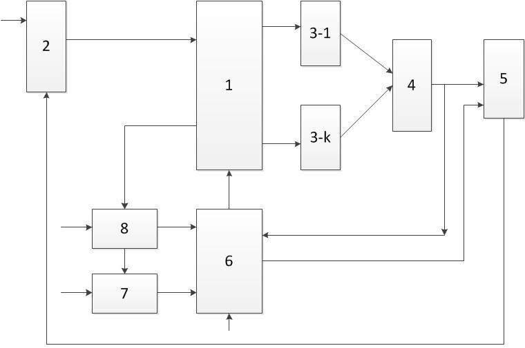
Fig. 1. Block diagram of the utility model "Information analytical system for support of decision-making in the field of sustainable development for marine planning in the Arctic zone of the Russian Federation taking into account different scales of climate change" (explanations in text below)
Fig. 1 shows the following blocks: 1 – block distribution of resources; 2 – forming unit resources; 3 - forming unit of private income; 4 - forming unit of total income; 5 - forming unit of share investment of resources; 6 - forming unit of comparison with an acceptable level of risk; 7 – forming unit of a time-varying set of natural risk (including climate risks) characteristic for the Arctic zone of the Russian Federation; 8 – forming unit of environmental monitoring, which is characteristic for sustainable development in marine planning in the Arctic zone of the Russian Federation taking into account different scales of climate change.
AS-2020 indicates the importance of Maritime activities within the coastal regions of the Russian Arctic especially in the area of North Sea Rout (NSR) which are the part of Russian Arctic transport system (RATS). We present on fig. 2 the map with our estimations of Marine Economic Potential (MEP) for Russian Arctic Zone by using indicator method and GIS-technologies [1]. According to our estimates, now Russian Arctic coastal regions can be divided into 2 groups:
- regions with a stable economic situation (Yamalo-Nenets Autonomous Okrug, Krasnoyarsk Krai, Republic of Sakha (Yakutia) and Chukotka Autonomous Okrug, the values of the MEP are in the range from 0 to 0.5);
- regions with unstable economic situation (Murmansk oblast, Republic of Karelia and Arkhangelsk region, values of MEP are within the -0.5 to 0).
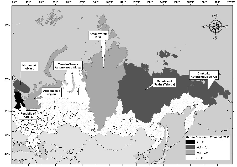
Fig. 2. Map of the Maritime economic potential of the Arctic coastal regions of Russia, as of 2011
For the Russian Arctic the main types of Maritime activities in the framework of AS-2020 will be the offshore extraction of hydrocarbon resources and transportation of goods using the NSR as a transport corridor. For such activities iceberg hazard is a source of catastrophic environmental risk of the first kind [4]. The importance of this factor is confirmed by the tragic incident with the ship "Hans Hedtoft" in 1959 during its first trip within the opening of regular Maritime traffic between Denmark and Greenland. The ship had collision with an iceberg in the conditions of the icy storm. All the passengers and crew members of ice class vessel with a displacement of about 3,000 tons died. This incident effectively put an end for the strategic plans of regular Maritime traffic to Greenland instead of the existing expensive air service. Iceberg risk management has to basing on the adequate models for the physical mechanism of the formation of iceberg risk [13-15] and advantageously carrying out with the use of tools to support decision-making for example as it on fig. 1.
We propose using geo-information management when managing iceberg risk in the Russian Arctic seas management [5-7], based on the wide use of geographic information systems (GIS) as tools to support decision-making. The use of GIS allows greatly enhance the visualization display capabilities for spatially-distributed objects of different nature on a common cartographic basis. For example, on the fig.3 displayed using GIS episode of attack of a group of five icebergs to the area of the Stockman gas condensate field (SGCF), the inner safety zone for SGCF. The episode that occurred in April 1987 was discovered by V. M. Abramov in the course of cluster analysis. The green points show the position of the icebergs from the group's invasion on April 8th 1987, and blue triangles indicate their position in the next episode of observations on April 10th. Black and red signs in the form of squares and polygons displayed icebergs that are not in the group of invasion. Evident continuity between episodes 8 and 10 April 1987 allows talking about the kinematic connection between icebergs recorded in these episodes. The front of the invasion coincides with the bandwidth of the Novaya Zemlya’s shelf bounded by the 200-meter isobaths as shown on the fig.3. During the invasion the icebergs are moving in sync, keeping the positional relationship. The figure also contains the provisions of the promising oil and gas fields, description of which are not included in this article.

Water changes of Atlantic and Pacific with Arctic Ocean are the very important factors for climate change in Arctic. We propose using of Argo buoys for those goals. The typical cycle of an Argo buoy is presented on fig.4 [11]. Note that now volume of Argo data overwhelms traditional sources and the quality of the data is high. Argo target called for temperature and salinity accuracies of 0.005 °C and 0.01 salinity units, with a pressure accuracy of 2.5 dbars (equivalent to a depth error of about2.5 m). About 80% of the raw profile data meet these standards, with little or no correction required [11]. The rest of the data are corrected using delayed-mode quality control procedures and eventually meeting the accuracy goals [11]. At present, about 90% of Argo profiles are distributed electronically within 24 hours of acquisition. [11].
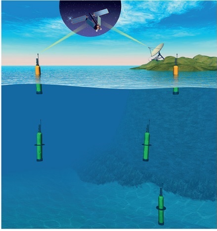
Fig.4 The typical cycle of an Argo buoy [11]
In the research we used developed sub databases “DB ARGO Bering” [12] and “DB ARGO ATL” [13]. Those sub DB contain data of around hundred Argo buoys. This array covers about fifteen-year period from 2001 till now. On recent stage essential goal is to study trajectory of Argo buoys from above mentioned sub DB for visualization of water masses movements. We found that one of Argo buoys from “DB ARGO ATL” with id #4901101 had unique long journey from warm waters near southern coast of Nova Scotia to high latitude arctic area near most northern cap of Novaya Zemlya. This trip began 2008 summer and lasted near five years. Over 180 vertical profiles of temperature and salinity provided with 10 days interval and transferred to ARGO Data Centers. Over year this buoy moved inside depth of Barents Sea dragged by Atlantic Waters. It crossed area of SGCF in 2012 and then came to northern cap of Novaya Zemlya where ended functioning at 2013 early spring. Till now it is the only Argo buoy appearance in the Barents Sea [13].
On fig. 4 we present all trajectories of Argo buoys from “DB ARGO Bering” within deep part of Bering Sea and near Pacific. Essential attention we contribute to Argo buoys that come and go by straits in Aleutian Islands to investigate patterns and scenarios of water exchange between the Pacific and deep water part of the subarctic Bering Sea [12]. Note that very first Argo buoy station within the Bering Sea was14 August 2001. As result of research we described the basic schema of Alaskan Stream waters influence on climate change in Arctic and Subarctic [12]. Also we illustrated the main ways of Alaskan Stream waters penetration into deep water part of the Bering Sea using Argo buoys trajectories. We found some cases with untypical buoy trajectories regarding known circulation system in the Bering Sea [12].
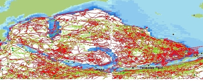
Fig.5. Trajectories of Argo buoys from “DB ARGO Bering” within deep part of Bering Sea and near Pacific
As Argo buoys have to reach the sea surface to transmit their data, they could not originally target ice-covered parts of the oceans [11]. But there is plan to expand Argo into Arctic Ocean some later when sea ice there will have seasonal character. Now there are new algorithms to help survive Argo buoys in icy waters [11]. On fig. 6 we present the map with scheme for future Argo zone in the Arctic Ocean where rose trapezoids use for calculating the extra Argo buoys resources. Green points on map are active buoys and ice stations.
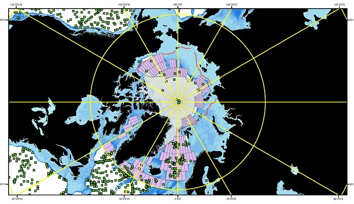
Fig.6. Scheme of future Argo zone in the Arctic Ocean
While discussion about future Argo zone in the Arctic Ocean we note it will be great move forward in Arctic Ocean study and recommend most important places for implementing: Barents Sea Opening between Norway and Svalbard, west and north of Svalbard, Fram Strait, Danish Strait and continental slope at Russian bank.
Let’s go to black carbon (BC) as climate change factor. Some specialists suppose that BC is one of the most important parts of aerosol or particulate matter (PM) that have influence on climate change and health [19]. Cities and especially megacities are the important sources of BC [15]. Currently measuring black carbon in Russia is not made. It is quite a significant portion of PM10 and a large part of PM2.5. The study of long series of measurements of PM10 and PM10 in large cities of Russia is important, including for the development of the national system of monitoring the income of black carbon in the Arctic [15]. In [15] we presented the strategy for development of basic clean technologies that have to be used within national BC controlling system (NBCCS) in the Russian Arctic as part of geo-information management, a most modern approach to the management of spatially-distributed systems and territories [5-7]. This NBCCS have to be compliant with other management systems as Air Quality Management and Integrated Water Resources Management for Russian arctic and subarctic rivers [8]. Also NBCCS developing strategy have to take into account common concept of environmental monitoring in the Russian Arctic [20], principles of different arctic and subarctic measuring methods and systems including remote sensing [10] and traditional ship expedition [9] that have to be used for support decision.
Cities and especially megacities are the important sources of BC [15]. On this stage of research we estimate content and variability of BC in the air of two Russian megacities Moscow [18] and St.-Petersburg [17] within decadal and climate scales. Till now there was no direct measurement of BC in Russia including Moscow and St.-Petersburg [17, 18]. We tried to assess the BC contents the air of Moscow [18] and St.-Petersburg [17] within decadal scales for the first time on the base of PM data with using method of analogues [16]:
considerable overlap.
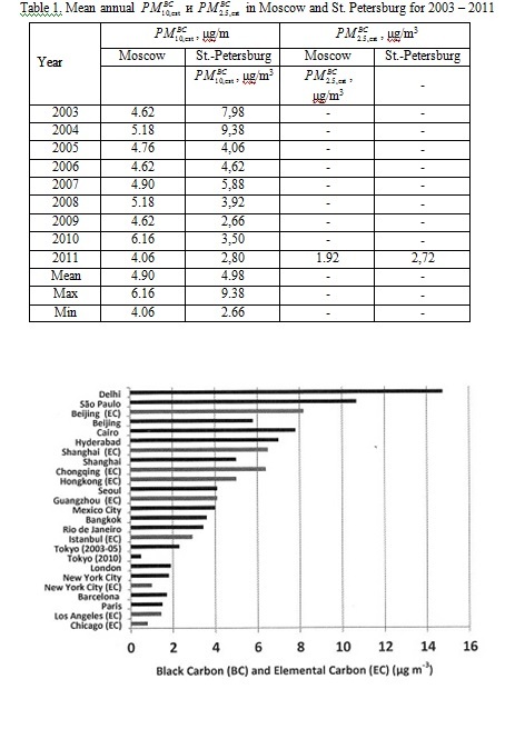
Fig. 7 Concentrations of black carbon (black) and elemental carbon (grey) observed in megacities across the world [22].
It was turned out that the average annual content of n Moscоw and St. Petersburg are between the indices of Istanbul and Hong Kong that are modern post-industrial megacities.
Let us discuss the recent picture of climate change in Arctic and possibilities of remote sensing in climate Arctic research. It is known that Arctic ecosystems have been afflicted by vast changes in recent decades [10]. Specialists know that changes in temperature, as well as precipitation, have an impact on snow cover, vegetation productivity and coverage, vegetation seasonality, surface albedo, and permafrost dynamics. The coupled climate-vegetation change in the arctic is thought to be a positive feedback in the Earth system, which can potentially further accelerate global warming [10]. Our research with different decadal data including remote sensing products shows that now climate change in Arctic has spot character [10, 23, 24] when some territories demonstrate positive trends in chosen climatic indicators but near them there are territories with negative trends or with mix ones.
The consistent and operational monitoring of different essential climate and ecosystem parameters is of high importance for future climate Arctic research. Earth observation data from various sources and techniques are available to retrieve spatial information and compensate the lack of ground measurements for remote areas. As the coverage of available meteorological stations in the Arctic is sparse, the interpolation between the climate stations is introducing uncertainties of unknown magnitude, which needs to be taken into account. Hence, the continuity of satellite observation services for the integration of long-term time series information into climate monitoring and modeling approaches is essential [10].
IV. Summary and conclusion
Socio-economic development within coastal systems of the Russian Northern seas is an important component of AS-2020. Important aspect while implementing AS-2020 is the management of natural risks and the development of measures to adapt to climate change. As we show in the article, the natural risks management and adaptation to climate change have be conducted with using innovative technologies for decision support, based on the principles of geo-information management with wide usage of GIS-technologies. In article we present the results of successful research over the last years in the Arctic and Subarctic Institute at the Russian State Hydrometeorological University (ASI RSHU). While research we use the instruments of international cooperation including personal contacts between leading researchers from different countries.
V. Acknowledgment
Platform https://www.researchgate.net/profile/Valery_Abramov2/?ev=hdr_xprf gave excellent opportunities to preliminary discussion and data exchange in the frame of this research. The Ministry of education and science of Russia provides financial support for this research with the state order 2525.2014/166.
1. Gogoberidze G.G., Karlin L.N., Abramov V.M., Lednova J.A., Malakhova J.A. Marine economic potential assessment for environmental management in the Russian Arctic and subarctic coastal regions, International Multidisciplinary Scientific GeoConference Surveying Geology and Mining Ecology Management, SGEM, Bulgaria, 2014.
2. Gogoberidze, G., Karlin, L., Abramov, V., Lednova, J. Indicator method of estimation of human impact assessment for coastal local municipalities, Measuring and Modeling of Multi-Scale Interactions in the Marine Environment - IEEE/OES Baltic International Symposium, BALTIC 2014, Estonia, 2014.
3. Lednova J., Gogoberidze G., Abramov V.M., Karlin L.N., Berboushi, S. Concept of environmental monitoring in the Russian arctic coastal regions, International Multidisciplinary Scientific GeoConference Surveying Geology and Mining Ecology Management, SGEM, Bulgaria, vol. 1, issue 5, pp 161-168, 2014
4. Karlin L.N., Abramov V.M. Environmental and ecological risks management, St.-Petersburg, RSHU, 2013 - 332 s.- DOI:https://doi.org/10.13140/2.1.1978.8482
5. Istomin E. P., Sokolov A. G, Abramov V. M., Gogoberidze G.G., Popov N.N. Geoinformation management as a modern approach to the management of spatially-distributed systems and territories, International Multidisciplinary Scientific GeoConference Surveying Geology and Mining Ecology Management, SGEM, Bulgaria, vol. 1, issue 2, pp 607-614, 2015.
6. Istomin E. P., Sokolov A. G, Abramov V. M., Gogoberidze G.G., Fokicheva A.A. Methods for external factors assessing within geoinformation management of territories, International Multidisciplinary Scientific GeoConference Surveying Geology and Mining Ecology Management, SGEM, Bulgaria, vol. 1, issue 2, pp 729-736, 2015
7. Istomin E. P., Sokolov A. G, Abramov V. M., Fokicheva A.A., Popov N.N. CLUSTERS WITHIN GEOSPATIAL INFORMATION MANAGEMENT FOR DEVELOPMENT OF THE TERRITORY, International Multidisciplinary Scientific GeoConference Surveying Geology and Mining Ecology Management, SGEM, Bulgaria, vol. 1, book 2, pp 601-608, 2016.
8. Abramov V.M., Karlin L.N., Gogoberidze G.G., Golosovskaya V.A. On route to Integrated Water Resources Management for Russian arctic and subarctic rivers, International Multidisciplinary Scientific GeoConference Surveying Geology and Mining Ecology Management, SGEM, Bulgaria, vol. 1, issue 3, pp 495-501, 2014.
9. Gogoberidze G., Abramov V.M., Lednova J., Karlin L.N., Isaev A., Khaimina, O. Main results of summer oceanographic surveys in the eastern gulf of Finland in the framework of the Topcons project, International Multidisciplinary Scientific GeoConference Surveying Geology and Mining Ecology Management, SGEM, Bulgaria, vol. 3, issue 5, pp 253-260, 2014.
10. Urban M., Forkel M., Hüttich C., Schmullius C., Herold M. Pan-Arctic Climate and Land Cover Trends Derived from Multi-Variate and Multi-Scale Analyses (1981-2012), Remote Sens. 2014, 6, 2296-2316; doihttps://doi.org/10.3390/rs6032296
11. Riser S.C., Freeland H., Belbeoch M. et all. Fifteen years of ocean observations with the global Argo array, Nature Climate Change, February 2016. - DOI:https://doi.org/10.1038/nclimate2872
12. Abramov V.M., Karlin L.N., Gogoberidze G.G., Alexandrova L.V., Popov N.N. Water exchange between the Pacific and the Bering sea with impact on climate change in the Arctic and Subarctic, International Multidisciplinary Scientific GeoConference Surveying Geology and Mining Ecology Management, SGEM, Bulgaria, vol. 2, issue 3, pp. 701-708, 2014
13. Abramov V.M., Karlin L.N., Gogoberidze G.G., Alexandrova L.V., Bournashov, A.V. On Atlantic water inflow to Arctic ocean: Unique Argo buoy trip across Atlantic and Barents sea, International Multidisciplinary Scientific GeoConference Surveying Geology and Mining Ecology Management, SGEM, Bulgaria, vol. 2, issue 3, pp. 661-668, 2014.
14. Karlin L.N., Abramov V.M., Ovsyannikov A.A. THE TEMPORAL STRUCTURE OF THE ICEBERG HAZARD IN THE CENTRAL PART OF THE BARENTS SEA, Oceanology, 2009, vol. 49, No 3.
15. Abramov V.M., Karlin L.N., Lednova J.A., Gogoberidze G.G., Popov N.N. Clean technologies development strategy for the national black carbon controlling system in the Russian Arctic, International Multidisciplinary Scientific GeoConference Surveying Geology and Mining Ecology Management, SGEM, Bulgaria, vol. 2, issue 4, pp 313-320, 2014.
16. Abramov V.M., Gogoberidze G.G., Popov N.N., Isaev A.V., Berboushi S.V. Method of assessment for black carbon random fields within Russia for climate management in the Arctic, International Multidisciplinary Scientific GeoConference Surveying Geology and Mining Ecology Management, SGEM, Bulgaria, vol. 1, issue 4, pp 953-960, 2015.
17. Abramov V.M., Karlin L.N., Lednova J.A., Malakhova J.A., Gogoberidze G.G., Berboushi S.V. Variability of particulate matter in Saint-petersburg megacity air within climatic time scale, International Multidisciplinary Scientific GeoConference Surveying Geology and Mining Ecology Management, SGEM, Bulgaria, vol. 2, issue 4, pp 599-606, 2014.
18. Abramov V. M., Popov N.N., Bachiev R.I. DECADAL VARIABILITY OF PARTICULATE MATTER IN MOSCOW MEGACITY AIR, International Multidisciplinary Scientific GeoConference Surveying Geology and Mining Ecology Management, SGEM, Bulgaria, vol. 2, book 4, pp 323-330, 2016.
19. Abramov V. M., Gogoberidze G.G., Popov N.N., Berboushi S.V., Bachiev R.I. SCIENTIFIC BASIS FOR THE ICEBERG RISKS MANAGEMENT WITHIN THE RUSSIAN ARCTIC SEAS IN THE FRAME OF RATIONAL NATURE USAGE IN A CHANGING CLIMATE, Proceeding of Russian Hydrometeorological University: theoretical research journal, 2015, issue 39, pp 132-141.
20. Bond T. C. et all. Bounding the role of black carbon in the climate system: A scientific assessment, J. Geophys. Res. Atmos., 118, 5380-5552, 2013. - DOI:https://doi.org/10.1002/jgrd.50171
21. Lednova J., Gogoberidze G., Abramov V.M., Karlin L.N., Berboushi, S. Concept of environmental monitoring in the Russian arctic coastal regions, International Multidisciplinary Scientific GeoConference Surveying Geology and Mining Ecology Management, SGEM, Bulgaria, vol. 1, issue 5, pp 161-168, 2014.
22. Samara C., Voutsa D., Kouras A., Eleftheriadis K., Maggos T., Saraga D., Petrakakis M. Organic and elemental carbon associated to PM10 and PM2.5 at urban sites of northern Greece, Environmental Science and Pollution Research, USA, 21(3), 2014. - DOIhttps://doi.org/10.1007/s11356-013-2052-8
23. Beekmann M. et all. In situ, satellite measurement and model evidence on the dominant regional contribution to fine particulate matter levels in the Paris megacity, Atmos. Chem. Phys., 15, 9577-9591, 2015. - DOI:https://doi.org/10.5194/acp-15-9577-2015
24. Abramov N.V. Climate warming and contemporary changes in the regime of the rivers within the water basin of Northern Dvina, Proc. of Final Session of RSHU Scientific Council, 2005, pp 3-5.
25. Abramov V.M. ICEBERG HAZARD FOR MARITIME ACTIVITIES WITHIN THE RUSSIAN ARCTIC IN THE CLIMATE CHANGE CONDITIONS, Proc. of 9th Int. Conference “GEORISK-2015”, Moscow, 2015, v.2, pp 443-448.