


BISAC NAT010000 Ecology
BISAC NAT045050 Ecosystems & Habitats / Coastal Regions & Shorelines
BISAC NAT025000 Ecosystems & Habitats / Oceans & Seas
BISAC NAT045030 Ecosystems & Habitats / Polar Regions
BISAC SCI081000 Earth Sciences / Hydrology
BISAC SCI092000 Global Warming & Climate Change
BISAC SCI020000 Life Sciences / Ecology
BISAC SCI039000 Life Sciences / Marine Biology
BISAC SOC053000 Regional Studies
BISAC TEC060000 Marine & Naval
The wide variety of economic activities, which prevail along the coasts, has either direct or indirect connectivity with the coastal ecosystems through its provisioning of a diverse range of goods and services. However, these systems are permanently under pressure due to natural and anthropogenic threats. This field based study documents the changing pattern of economic activities along selected coastal stretches in South Asia at Bangladesh, India and Sri Lanka. Economic activities vary with coastal ecosystem types and service flows there from. Field study sites were identified based on multiple meetings and discussions with the policy makers in each of the countries and they continued to be the part of scientific discussions within ecology-economy framework through the project lifetime. In depth enquiry and analysis were carried out to understand perception of various economic stakeholder groups to natural and anthropogenic threats in the coastal regions and resultant vulnerability and risks. Often threats get intensified by rapid urbanization triggered by changing pattern of coastal economy due to tourism expansion and modernization of traditional activities.
Coastal Ecosystem, Economic Activities, Threats, Vulnerability, Risk, Resilience.
I. Introduction
From an economic perspective, ecosystem services are generating livelihood/income/meeting basic needs for the people thereby contributing to human welfare [1]. At the global level, coastal population densities are almost three times larger than that of inland areas [2] with an exponential rise over the years [3]. Very high population density characterizes South Asian coasts [5]. The wide variety of economic activities, which prevails along the coasts, has either direct or indirect connectivity with the coastal ecosystems through its provisioning of a diverse range of goods and services [4; 5]. Globally coastal ecosystems have been experiencing rapid alteration [3; 6; 7; 8] by either human-induced risks or natural forces [9; 10]. It necessitates a better understanding of the extent of human dependence on ecosystem services to assess the vulnerability and risk of coastal ecosystem based economy and resilience. Asian countries like India, Bangladesh, and Sri Lanka share almost 1.35 per cent of the global coastline [4] and are experiencing fast changes over past four to five decades. Objective of this study is to understand the coastal ecosystem types in the three countries and how and why economic activities are changing over time relating them to ecosystem service flows. How communities perceive various sources of threats to their economic activities are also analysed.
II. Framework of Study and Methodology
For selecting the study sites with closer look in Bangladesh, India and Sri Lanka we have focused on economic activity induced, developmental policy led and population pressure induced changing coastlines. Using semi structured questionnaires the natural and anthropogenic threats faced in the study sites were identified. The sites represent varied coastal ecosystem types and thus service flows and economic activities. In the three countries in South Asian Coasts various economic groups were interviewed to understand various threat related risks they perceive, how effective they think are the adaptive measures taken by the local administrative bodies against natural events. Same field survey instrument was used to facilitate cross country comparison. The study draws data mainly from primary field surveys in selected study sites in three countries and also from official sources. Field visits were mainly organized to obtain information on socio-economic and demographic characteristics of people living in these sites, changing patterns in economic activities over the years and also to identify important threats (natural and anthropogenic) to different economic activities and ecosystem types, vulnerability, risk perceptions and ongoing intervention strategies available and implemented so far to reduce the impact of such threats from the perspective of different stakeholders in the study sites.
We adopt the risk-resilience framework (Fig. 1) [5] based on literature to frame various questions for our field survey. Various threats in coastal areas driven by environmental change and human activities [11] impact coastal ecosystem based economies through their vulnerability to multiple threats, risk perception and level of resilience determined by adaptive capacity, sensitivity and exposure-three components of vulnerability [12]. Exposure is the magnitude and duration of the climate-related events [13; 14]. Sensitivity is the degree to which the system is affected [15; 16] by the exposure. Adaptive capacity is the system’s ability to withstand or recover from the exposure. Adaptation involves reducing risk and vulnerability, seeking opportunities and building the capacity of nations, regions, cities, various stakeholders and natural systems to cope with stresses, as well as mobilizing that capacity by implementing decisions and actions. Adaptation options can be implemented either to modify the drivers or exposure and vulnerability or both [12]. Risk refers to the potential for adverse effects on lives, livelihoods, health status, economic, social and cultural assets, services (including environmental), and infrastructure due to uncertain states of the world. Risk can also be subjective in the sense that the likelihood and outcomes are based on the knowledge or perception that a person has about a given situation [12]. Resilience [15; 9; 17] is a concept that takes into account how systems, communities, sectors, or households deal with disturbance, uncertainty and surprise over time, and it is characterized by both adaptability and transformability.
The schematic of the complex links of interdependence among vulnerability, risk and other components as mentioned above are presented below (Fig. 1):
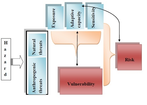
Fig 1. Components of Vulnerability, Risk and Resilience Assessment Framework
As mentioned in Resilience Assessment framework schematic diagram we need to generate some scores to arrive at the quantitative assessment of risk levels. As a first step, basic survey data is normalized using the formula (1), where xmax and xmin are maximum and minimum value points respectively.
(1)
As a result of this normalization, new transformed variables are obtained that range from 0 to 1. We consider all the data we got as reflecting baseline information as planned no targeted adaptation has been taken up in the study sites. So as per equation 1 adaptation score can be taken as zero so final formula for assessing ‘baseline vulnerability’ at study sites can be rewritten as:
Vulnerability = Exposure x Sensitivity (2)
Exposure is estimated by using information on frequency of occurrence of a threat (stress) taken from the responses to the questionnaire. Higher the frequency, greater is the stress (exposure). Whereas sensitivity is the degree to which the system is affected by the exposure. System here refers to “economic activity”. Sensitivity is estimated with the help of information on intensity of impact of threats on various economic activities from our questionnaire. Formula (3) provides an assessment of vulnerability of an economic activity in the absence of interventions.
Changes (increase or decrease) in vulnerability of the system can be examined after factoring in risk using the following formula:
Vulnerability x Risks associated with vulnerability (3)
The main focus of this assessment is to identify, from the field level first hand information, the most vulnerable from among current economic activities in each study site and also in determining the risks of each economic activity to understand resilience to threats identified.
III. Study Sites
Bangladesh: Cox's Bazar Sadar-Moheshkhali.
The study site, Cox's Bazar Sadar-Moheshkhali is located in the Cox's Bazar district of the Chittagong division, Bangladesh. The site lies between 21023'16" to 21046'26" N latitude and 91050'34" to 92007'50" E longitude and is located about 390 km from Dhaka capital city and 152 km south from Chittagong city on the east coast of the Bay of Bengal.
Table 2: Major ecosystem types in Cox's Bazar Sadar-Moheshkhali area
|
Ecosystem type |
Major locations on Cox's bazar Sadar-Moheshkhali coastline |
|
Mangrove |
Sonadia Island, Moheshkhali |
|
Coastal mudflats |
Sonadia Island, Moheshkhali, Cox's Bazar Sadar |
|
Estuaries |
Cox's Bazar Sadar, Moheshkhali, Sonadia Island |
|
Sandy beaches |
Laboni Sea Beach and Kolatoli (Cox's Bazar Sadar), Sonadia Island, Moheshkhali |
|
Sand dunes |
Cox's Bazar Sadar, Sonadia Island |
|
Forest |
Cox's Bazar Sadar, Moheshkhali, |
The area is famous for natural sea beach and tourist place. It has an economy supported primarily by tourism for which a large number of hotels, guest houses and motels have been built in the city and coastal region. A number of people are also involved in fishing and collecting seafood and sea products for their livelihood. A number of people are also involved in the transportation business for tourists. Cox's Bazar area is also one of the few major spots for aquaculture in Bangladesh. It is considered a major source of revenue from foreign exchanges. Beside a mix of small-scale agriculture, marine and inland fishing (shrimp) and salt production are other industrial sources from this region that play important roles in the national economy.
The population density of the study area is quite high compared to national average, particularly at Cox’s Bazar Sadar which is 2011 persons per sq. km, while there is 744 persons per sq.km at national level. At the same time population growth rate is also quite high at Cox's Bazar Sadar which is 3.21 percent over 1.67 percent at national level. The beach of Cox’s Bazar is the natural beach covered by hill side. This sandy beach slanting downward and join with Bay of Bengal. The sandy beach near Cox’s Bazar town is wider than other side and the sand in here is very. Landforms of the study area of Cox’s bazar are the coast, beach and shore, offshore, back shore, and sand dunes. Including that most dunes are lengthy. The depositional features like bar and spit, offshore, coastal, slot, marshes, lagoon and marine dunes are shown on the study area.
Seasonal monsoon winds and maritime action of the Bay of Bengal the Cox’s Bazar coastal region experiences heavy rainfall and humid climate due to its proximity to the sea. The Cox’s bazar sea beach is exposed to a number of adverse of natural phenomena like cyclone, coastal erosion, salinity and possible threat from sea level rise. The causes of such ravages are both natural and manmade. Many positives roles the cyclones play on the biology and ecosystem of the coast, such as, supply of nutrients for the aquatic animal. The coastal and island site are rich in biodiversity, but that are degrading for which efforts are being given to remove all threats to biodiversity within its focal areas. People living within the Cox's Bazar site are heavily dependent on fisheries, marine products and, to a lesser extent, agriculture for their livelihood. The storm level, rise of sea water moves the salt water interface landwards, making agriculture more and more difficult (traditional rice crops) which are not salt tolerant. Saline are extended of coastal lowland in Cox’s Bazar.
Sonadia Island supports the last remaining remnant of mangrove forest in southeast Bangladesh, which once stretched along much of the coastline of Chittagong and Cox's Bazar. In addition to this important mangrove area, the island supports a large number of water birds, mollusks, echinoderms, and marine turtles. The coastal region of Cox’s Bazar has a unique position of its condition of natural resources endowment. The coastal region has also the potentials to supply fish not only the domestic consumption all over the country. Fish, forest, agriculture and tourist resources of Cox’s Bazar are important not only the coastal region alone but also for the country.
India: Digha-Sankarpur coastal area.
The field site, Digha-Sankarpur is located in the East Medinipur district (Ramnagar I and II blocks) of the State of West Bengal, India latitude 21₀ 37’ N and longtitude 87 ₀32’ E. Digha is located 187 km from Kolkata on the east coast of the Bay of Bengal and is a popular beach resort with a 6 km long beach [18]. Digha Planning Area is a coastal tract adjoining the Bay of Bengal in the south and the border of West Bengal- Orissa in the east. The planning area is under the jurisdiction of Digha Sankarpur Development Authority (DSDA) comprising 51 mouzas covering an area of around 70 m sq.km. It comprises beach areas of Dattapur (bordering Orissa), Digha (old and new), adjoining Sankarpur, Tajpur and Mandarmoni having a length of approximately 17 kms.
The major ecosystem types of the region are presented in Table 3.
Table 3: Major ecosystem types in Digha-Sankarpur
|
Ecosystem type |
Major locations on Digha-Sankarpur Coastline |
|
Sand dunes, Sandy and muddy beach |
Dattapur |
|
Old Digha |
|
|
New Digha |
|
|
Sankarpur |
|
|
Tajpur |
|
|
Mandarmoni |
|
|
Estuaries |
Dattapur |
|
Tajpur |
|
|
Casurina, Cashewnut, Screw Pine, Date, Coconut and other plantations |
Dattapur |
|
New Digha |
|
|
Old Digha |
|
|
Sankarpur |
|
|
Tajpur |
|
|
Mandarmoni |
While close to 27 per cent of the total population of India lives in coastal areas and a smaller percentage (1.47) of the total coastal population of the State of West Bengal lives in Digha-Sankarpur area. According to the Census of India 2011, Digha- Sankarpur area shares less than 2 percent area of the Purba Medinipur district while the district shares around 5 percent of the total area of West Bengal. The population of Digha- Sankarpur is less than 1 percent of the total population of Purba Medinipur. However, the population density of Digha-Sankarpur is greater with 517 persons per sq. km than the coastal population density of India which is around 164 persons per sq.km.
Digha- Sankarpur coast is a mesotidal coast (with tidal amplitude varying between 2-3 m) while the Sundarbans coast is a macrotidal coast (with tidal amplitude exceeding 4 m) The tide, semidiurnal (i.e. high tide occurs twice a day) in nature, has some diurnal (once a day) influence also regarding the height of the daily two high tide levels and low tide levels. Highest tidal position is obtained in the month of August creating maximum impact on the coast. The rate of relative sea level rise is over 3mm/year and this makes some contribution to the coastal erosion over a longer time span [19]. Comparable figures for Sundarbans show that sea level is rising at the rate of 3.14 mm a year. [1] The entire beach area from Dattapur at the border with Orissa in the west to Mandarmoni in the east is fragile and suffering from varying degrees of erosion. It is vulnerable to coastal erosion in stretches, inundation due to periodic storm and tidal surges which may extensively damage the property due to seasonal high velocity winds, storms and cyclones. The average erosion along the entire stretch is around 15 m per year coupled with net lowering of beach level to the tune of 0.05 m per year [20]. Such erosion and lowering of beach is adding greater impact of wave action to the coastal protection works, constructed since seventies, in phases to check ingress of tidal water in the countryside and to prevent landward movement of the sea. Saline water intrusion is severely affecting the surface and ground water in Digha due to the indirect effect of shore line shifting in this region.
The beach, in the Digha-Sankarpur area is a smooth uniformly sloping (average 1.75) made up of fine grained sand and silt. On the landward side, the beach is bounded by dune cliffs. The shore-line from Digha Mohana to the east in Sankarpur region is relatively stable. In the far-west near the Orissa border it is accretional and muddy. But, the entire strip, where the Digha Township is located, in between, is an eroding type, which is the main concern of this area (www.dsda.gov.in). The material of the beach consists of mainly sand mixed with clay and the dune material is made up of fine sand. The entire beach of Digha is dotted with Casuarina plantations that sprung up over the sand dunes. The sand dunes are the most outstanding morphological feature of the coastline. This dune belt runs almost parallel to the present shore line, though the width and height vary from place to place. These dunes generally rise up to 12 meters, though the height decreases towards the east. The dunes are transverse in type and their character changes with the increasing distance from the sea. They are more stable and more under vegetation cover towards north. During summers, the strong winds shift the location of the dunes. The consistent wind direction at least during summer monsoon is one of the chief factors of their origin.
Sri Lanka: Koggala area in the Habaraduwa Divisional Secretariat (DS) division.
The study area, the Southern Province, has 3 districts – Galle District, Matara District and Hambantota District. The Coastal Zone (CZ) width in Galle District is highly irregular and narrow in certain places. As such, the adjoining DS division may also show geographical, biological and social features characteristic of coastal zone. Since most socio-economic data are collected by government agencies in terms of DS divisions, it is convenient to base the study using the DS division as the monitoring entity.
Table 4 gives some of the key features of the Coastal Zone DS divisions in each of the 3 districts, including the percentages of the CZ area to the district area and the percentage of the CZ population to the district population.
Table 4: Key features of the coastal zone in the 3 districts in the Southern Province
|
Districts in the Southern Province |
Coast-line (km) |
Area in CZ (km2) |
PC of Dist. Area% |
Average width of CZ (km) |
Pop’n CZ (2012) |
PC of Dist. Pop’n% |
Pop’n Density per km2 |
|
79.3 |
323 |
19.6 |
4.1 |
438,359 |
41.4 |
1,655 |
|
|
Matara Dist. CZ |
51.2 |
182 |
14.2 |
3.6 |
289,830 |
35.8 |
1,569 |
|
H’tota Dist. CZ |
145.5 |
1,483 |
56.8 |
10.2 |
269,442 |
45.2 |
269 |
|
Southern Prov. CZ |
276.0 |
1,988 |
|
6.0 |
997,631 |
|
1,164 |
Source: [21]
Table 5 shows the extents of different ecosystems in the Southern Province. It is noted that a diversity of ecosystems exist in the Hambantota District compared to the other two districts.
Table 5: District-wise distribution of coastal ecosystems in the Southern Province
|
District |
Mangroves |
Salt marshes |
Dunes |
Beaches, Barrier beaches, Spits |
Lagoons Basin estuaries |
Other water bodies |
Marshes |
|
Galle |
238 |
185 |
- |
485 |
1,144 |
783 |
561 |
|
Matara |
7 |
- |
- |
191 |
- |
234 |
80 |
|
Ham’tota |
576 |
318 |
444 |
1,099 |
4,488 |
1,526 |
200 |
|
Southern P |
821 |
503 |
444 |
1,775 |
5,632 |
2,543 |
841 |
|
National |
12,189 |
23,819 |
7,606 |
11,800 |
158,017 |
18,839 |
9,754 |
Source: [22]
The study site comprises an area surrounding the Koggala Lagoon including a narrow strip of land bounded by the sea on the south and by the lagoon on the north and lying between Habaraduwa Town on the west and Ahangama on the east where the Habaraduwa DS division ends. The area to the north of the lake extends about 4 km from the shore covering mostly agricultural land. In this area, the boundary extends into the Imaduwa DS division. The west and east boundaries are close to 125 km post and 138 km post on the Galle – Matara highway, respectively. This highway as well as the Matara railway line runs along this land strip. The width of the land strip is about 1-2 km between the sea and the lagoon. The strip of land belongs to the village of Koggala lying within the Habaraduwa DS division which has its northern boundary just above the lake towards the east end. The study site lies 17 km from the district capital of Galle and 130 km from Colombo, the country’s capital.
Some of the on-going activities and features in this area are:
- Presence of an industrial zone
- Presence of a wide sandy beach and submerged reef
- Presence of a large number of tourist hotels and guest houses
- Presence of the lagoon / estuary with mangroves on its bank
- Presence of agricultural activities
- Site for traditional fishing including inland fishing
- Belongs to the wet climatic zone
There are altogether over 60 villages in Habaraduwa DS division, and the study was conducted covering about 15 villages. Using GIS maps of villages and the 2012 Census on population at village level, population density values were determined. The total area of the study site is 39 sq. km, and its average population density is 1,254 per sq. km.
Koggala is a popular destination for both local and foreign tourists because of its wide sandy beach and reef. The Koggala Industrial Zone (KIZ) largely focused on textile and apparel manufacturing is located towards the east end of the land strip. On the west end lies a small air field constructed by the British during the Second World War and currently used by the national air force. The land to the north of the lagoon comprises mostly marshes and paddy fields. Beyond the paddy fields, the land begins to rise where it is covered with tea, cinnamon and rubber plantations, amidst homesteads, losing the coastal character. In order to keep the Koggala beach clean for the benefit of the tourists, no marine fishery activities are allowed within the stretch from Habaraduwa to Ahangama.
Though by law the beach is accessible to the public, the hotels built across the beach discourage people from entering the beach where western tourists do sun-bathing and spend their time at leisure. For the same reason, there are no vendors or photographers or other activities of any economic significance being carried out on the beach. In fact, in Sri Lanka, no vehicles, manual or motorized, are permitted to be driven along the beaches. However, in certain other parts of the country, there are more sports activities being carried out on the beaches where the public have free access to the beach.
Major ecosystem types in the study site are: Sandy beaches, Koggala Lagoon, Submerged reef, Mangroves at Koggala Lagoon.
IV. Analysis and Discussion
In all the three countries: Bangladesh, India and Sri Lanka costal study sites are facing population pressure with very high population density way above national and country level average coastal population densities. Despite variety of ecosystem types in South Asian region fishery and agriculture dominated the traditional livelihood pattern but new activities are heavily biased towards tourism related activities and services.
Bangladesh: Survey Outcomes
- Coastal Ecosystem and Economic Interaction
Coastal ecosystem types existing in different locations of Bangladesh study site are mangroves, coastal mudflats, estuaries, sandy beaches, sand dunes and forest.
From the sample population surveyed in different different locations at Cox's bazar-Moheshkhali area, a changing pattern of economic activities in each of these locations is observed (Table 2). It was observed that the reasons behinds the shifting of agriculture to other economic activities is mainly because of the rapidly growing saltpan-shrimp farming and tourism in the study area. The salinization of land, disappearance of forests, depletion of livestock due to disappearance of grazing land and scarcity of fodder such as rice straws has led to the fall in the productivity of traditional mono-cropping i.e. aman rice. On the other hand, encroachment of saltpan-shrimp farming due to both demand for salt and shrimp and population pressure has led unemployment in agriculture. However, people took the advantage of this ecosystem change and started to intensively salt-shrimp farming and adapt their livelihoods to accommodate changes in ecosystems. The employment opportunity and wages are higher in salt-shrimp farming compared to agricultural sector. Although marine catch fish activities have some challenge and threat, still the involvement of new people in this business are increasing primarily due to high price of marine fishes and demand of dry fishes and related indirect activities. The infrastructural and accommodation facilities for the tourists have been increased at a very high rate in the recent decade. This has facilitated employment opportunities in the tourism sector. Many people those were engaged in agriculture changed their livelihood by involving themselves in this sector. Besides, due to exploring many new economic activities on and near coast related to fishing and tourism some people shifted to these new activities from agricultural sector.
Table 6: Shift in occupations from traditional to new in Cox's bazar-Moheshkhali study site
|
Location |
Traditional activities |
New economic activities |
|
Cox's Bazar Town/Sadar |
Fishing, fish business, fish drying, small scale business, Agriculture |
Fish drying, hotel and restaurant |
|
Kolatoli |
Agriculture, small scale business (grocery shop, tea stall), betel leaves trading |
Shrimp fry, shop business |
|
Laboni beach |
Hawking, photography, |
Speed boar driving, beach concert, hawking on the beach |
|
Moheshkhali |
Agriculture, fishing, betel leaves trading, aquaculture |
Hotels and resorts, shrimp farming and salt production, fish drying |
|
Sonadia Island |
Agriculture, fishing, mangrove |
Shrimp farming and salt production, fish drying |
Source: Primary Survey
Though agriculture in Sonadia Island is not well developed due to the lack of cultivable land, poor sandy soils, the risk of flooding by saline water, a lack of irrigation facilities and sand storms, the land under agriculture is increasing. The conversion of habitat to agriculture, the cultivation of exotic and hybrid species, the use of chemical pesticides and fertilizers and sand dune vegetation grazing by livestock have led to involve some people in agriculture and livestock for their livelihood. Shrimp farms and saltpans are established by clearing areas of natural mangrove and converting mudflats and creating embankments. This has also facilitated to involve some people in Saltpan-shrimp farming. The involvement of people is increasing in the winter camps for the marine and coastal fisheries as well as sun drying of marine fishes. Firewood collection and it’s commercial use are important economic activities of some people in the island. Some people are also involved in invertebrate collection and business from the mangrove forest. Fig. 2 shows the Pattern of shift in activities from traditional to new and also the major drivers of change.
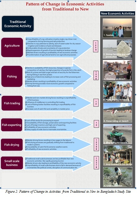
- Perception of threats to the Coastal Ecosystem based Economic Activities
The region is prone to devastating cyclones, landslides and water surge. Further, it is expected that sea level rise will cause river bank erosion, salinity intrusion, flood, damage to infrastructures, crop failure, fisheries destruction, loss of biodiversity, etc. along this coast. Coastal storms followed by sea water intrusion and flooding due to heavy rain are the natural threats that the coastal community of Cox's Bazar- Moheshkhali perceive as major. Around 49 percent of the sampled population opined that coastal storms are a major threat for the coastal community. Seawater pollution as a result of wastewater discharged from hotels and restaurants and running of petrol or diesel vehicles on the sea beach are two important anthropogenic threats that are regarded as major concerns for the coastal community. Seawater intrusion affects agriculture, salt-shrimp farming and fish drying equally, while such impact was least on hoteliers and none on other activities. Flooding due to heavy rainfall impacts the most salt-shrimp farming, while inadequate rainfall affects agriculture similarly. Cox’s Bazar sea beach and the ecosystem are under great threat from erosion due to unplanned development of resort area by cutting hills, establishment of shrimp hatcheries along the seashore, deforestation, over-fishing, salt fields, hill cutting for unplanned construction and tourism activities. Coastal erosion has little impact on hoteliers as erosion of sea beach area is perceived as quite common. Wastewater pollution and running of vehicles impacts tourism and fishing sectors the most. These two threats are also fair issues of concern for agriculture and fish drying. Besides, sand mining have little impact on hotel industry and agriculture. The major natural and anthropogenic threats as perceived by respondents are shown in Table 7.
Table 7: Identification of threats (natural and anthropogenic) to economic activities in Cox’s Bazar-Moheshkhali
|
S.No. |
Threats |
Percentage response |
|
|
Natural: |
|
|
1 |
Coastal storms |
48.72 |
|
2 |
Sea water intrusion during high tide |
21.79 |
|
3 |
Flooding due to heavy rainfall |
15.38 |
|
4 |
Inadequate rainfall |
10.26 |
|
5 |
Coastal erosion |
5.13 |
|
|
Anthropogenic: |
|
|
6 |
Wastewater from hotels and restaurants polluting the coast and the seawater |
20.51 |
|
7 |
Running of petrol or diesel vehicles on the beach resulting in the pollution of the beach |
19.23 |
|
8 |
Sand mining |
7.69 |
Source: Primary Survey
Vulnerability is assessed for both natural and anthropogenic threats though the scales are different depending on the number of threats within these two broad categories. The vulnerability levels across all economic activities been studied are quite low; in some cases close to insignificant vulnerability. The lowest vulnerability score is reported by the photography followed by hoteliers and hawking, while the highest relative vulnerability levels have been reported by the agriculture followed by salt-shrimp farming.
For risk analysis four risk types are considered relevant from the perspective of an economic activity, which are: asset loss (shop loss/ fishing boat loss, etc.), income loss, risk to lives and health risk. Given these risk types, such an assessment for anthropogenic threats is not considered meaningful, hence risk is assessed vis-à-vis natural threats only. Majority of economic activities are not associated with high levels of four risk types, except in the field of agriculture and fishery, where coastal storm is considered as very significant risk. Coastal storm is also exhibited as medium risks for salt-shrimp farming, hotel industry, fish drying and shop business. Among other threats inadequate rainfall is also a considerable risk for agriculture and flooding due to heavy rainfall is medium risk for salt-shrimp farming.
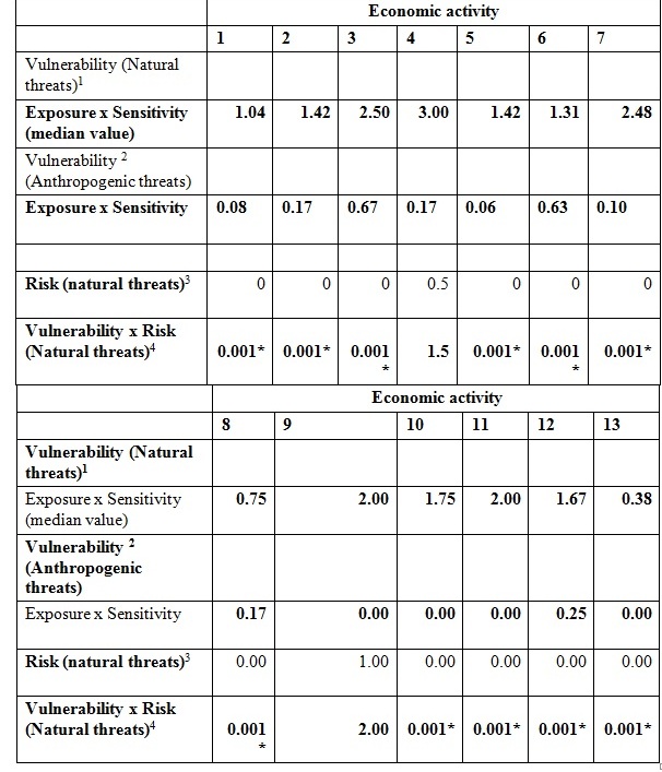
Vulnerability of various economic activities to different threats is shown in Table 8. Factoring in risk in vulnerability assessment scores does not change the overall results, since the risk to all the natural threats combined together is mostly closed to 1 implying existing of very marginal risk types associated with different natural threats.
Table 8: Assessment of vulnerability of different economic activities with and without risk (based on median values)
|
Threat |
Economic activity |
|||||||
|
1 |
2 |
3 |
4 |
5 |
6 |
7 |
8 |
|
|
Vulnerability (Natural threats)1 |
||||||||
|
Exposure x Sensitivity (median value) |
0.38 |
0.25 |
0.50 |
0.17 |
0.25 |
0.25 |
0.08 |
0.17 |
|
Vulnerability 2 (Anthropogenic threats) |
||||||||
|
Exposure x Sensitivity |
0.08 |
0.25 |
0.00 |
0.37 |
0.08 |
0.00 |
0.00 |
0.17 |
|
|
|
|
|
|
|
|
|
|
|
Risk (natural threats)3 |
3.0 |
2.0 |
2.0 |
1.5 |
1.5 |
1.0 |
1.0 |
2.0 |
|
Vulnerability x Risk (Natural threats)4 |
1.13 |
0.50 |
1.01 |
0.25 |
0.38 |
0.25 |
0.08 |
0.33 |
Notes: 1- Vulnerability ranges from 0 to 20 depending upon the number of threats considered in estimating exposure and sensitivity.
2- Vulnerability ranges from 0 to 9
3- Risk ranges from 0 to 4.
4-Vulnerability is very small since risk is zero
Note: Economic activity 1 refers to agriculture, 2- fishing, 3-salt shrimp,4-hotel and restaurants, 5-fish drying, 6-hawking,7- photography, 8- shop business
India: Survey Outcomes
- Coastal Ecosystem and Economic Interaction
Digha-Sankarpur coastal belt of India contains ecosystem types like sandy and muddy beach, sand dunes, estuaries, coastal forest. The coastal ecosystem based traditional and new economic activities are mentioned in the following Table (9) for different locations across the study site.
Table 9: Traditional and new economic activities in Indian study area
|
Location
|
Traditional activities |
New economic activities |
|
Dattapur |
Agriculture, fishing, small-scale business (grocery shop, vegetable seller, tea stall). |
Hawking on the beach and motorbike riding on beach, shell-crafting, motorized van- driving, photography on the beach. |
|
New Digha |
Saltmaking, masonary, blacksmith, agriculture, fishing, small-scale business (grocery shop, tea stall, garment shop, manual van driving, hotels and resorts, betel leaves trading, fish business. |
Hawking on the beach, hotels and resorts, manual van driving, motorized van driving, horse-riding on beach, photography on beach, water sports, car driving, restaurants, shell-crafting. |
|
Old Digha |
Fishing net business, aquaculture, fishing, agriculture, hotels and resorts, manual van driving, village folk singer, fish business and small scale business (grocery shop, vegetable seller, tea stall) |
Hawking on the beach, hotels and resorts, manual van driving, motorized van driving, horse-riding on beach, photography on beach, car driving, restaurants, shell-crafting. |
|
Sankarpur |
Agriculture, fishing |
Hotels and resorts, hawking on the beach, shell-crafting, motorbike riding on the beach, photography on the beach. |
|
Tajpur |
Agriculture, fishing, aquaculture |
Hotels and resorts, hawking on the beach, restaurants, motorbike riding on the beach, photography on the beach. |
|
Mondarmoni |
Agriculture, fishing, aquaculture |
Hotels and resorts, water sports, hawking on the beach, photography, motorised van driving, motor-bike riding on the beach and road for tourists. |
Source: Primary Survey
From the sample population surveyed in six different locations at Digha-Sankarpur, a changing pattern of economic activities in each of these locations is observed. We categorized the reasons for change into four major heads; economic factors, poor input availability, external factors and natural factors.
It is observed that a major reason leading to shift out of agriculture to other economic activities (like van driving, photography on the beach, shell crafting, hawking on the beach, etc.) is mainly because of economic reasons. For instance, increasing cost of cultivation is reported to be an important factor leading to this change. The other important reason is the lack of irrigation facility, less capital investment in other activities compared to agriculture, lack of availability of agricultural labour. A few respondents have also reported technological reasons behind shifting from agriculture to other activities. In addition, increasing demand for other activities over the years have made agriculture less lucrative and people also find this activity laborious compared to other recent alternatives. In particular, income from setting-up stalls or kiosks is considered more stable due to tourism development compared to agriculture which is dependent on many factors. In some cases, pest attacks in agricultural farms have led farmers to give up agriculture and look for other alternative occupations. At times, storm surge and flooding have destroyed agricultural fields resulting in a huge loss for the farmers.
Like agriculture, fishing is also an old, traditional activity which has been a source of livelihood for many households for generations. However, people are now beginning to move out of fishing in search of other profitable occupations. For instance, many individuals/ households have given up fishing and other related businesses for van driving, horse-riding on the beach, shell-crafting, photography on the beach, setting up temporary stalls on the beach and so on. Fishing is also considered as a laborious activity with returns that are not commensurate to the effort involved compared to other activities. Also, fishing is considered dangerous especially during rains. Other reasons cited are the decline in fish catch (i.e., decline in the provisioning service of the ecosystem) and also international pressure in terms of fishermen from neighbouring countries taking away a substantial catch. Even the number of local fishermen with mechanised trawlers have also increased making it difficult for poor fishermen (with non-mechanised gears) to get the same catch as before. Moreover, fish business (of drying and selling) requires initial capital investment unlike activities like photography and horse-riding on the beach. Increasing demand for tourism related products and activities is forcing people to move out of fishing into these newer activities. Shifts in occupation are also observed for other traditional activities like salt-making, masonry, blacksmith, small businesses (e.g., tea stalls, betel leaves trading, garment shops, etc.) These traditional activities are considered less remunerative and more laborious. The overall scenario of change in activities from traditional to new along with the major reasons for shift ate shown in the following Fig. 3.
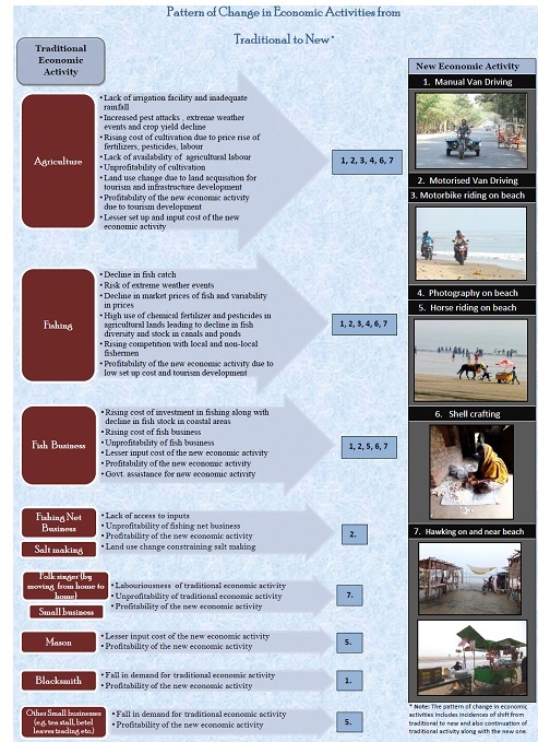
Fig 3: Pattern of Change in Activities from Traditional to New in Indian Study Site
- Perception of threats to the Coastal Ecosystem based Economic Activities
Some of the major threats as perceived by individuals pursuing different economic activities/direct stakeholders in Digha-Sankarpur are shown in Table 10. As is evident from the table, coastal erosion, sea water intrusion and coastal storms are the three most important natural threats that the coastal community of Digha-Sankarpur is facing. Around 78-79 percent of the sampled population considers coastal erosion and sea water intrusion as two major threats while close to 54 percent reported coastal storms as a major threat. As for the anthropogenic threats, wastewater discharged from hotels and restaurants polluting the coast and the seawater is a major concern for this community (around 50 percent). These findings are supported by a disaggregated picture across different economic activities. Sea water intrusion is a major threat for stakeholders engaged in economic activities like photography and horse-riding on the beach and fish drying (100 percent response). Coastal storms impacts aquaculture the most (80 percent) while hoteliers are the least impacted. Similarly, wastewater polluting the coast and sea water impacts aquaculture the most (100 percent response), agriculture the least (22.22 percent) and hoteliers (33.33 percent). Economic activities mainly dependent on the condition of the coast are mostly affected by pollution on the beach and sea water. Running of vehicles and waste water pollution are major issues of concern for these small-scale activities like, shell-crafting, photography and horse-riding on the beach.
The results show that most of the economic activities in Digha-Sankarpur, India are mainly impacted by natural threats like, coastal erosion, sea water intrusion, coastal storm and anthropocentric pollution caused due to wastewater discharged from hotels and restaurants on the beach. The intensity of exposure to different threats is estimated on the basis of the frequency of occurrence of these threats on a varying time scale. Among the list of economic activities covered, it appears that economic occupation category photography on beach is exposed to all the natural threats though the average current exposure level is marginal. As for the exposure to anthropogenic threats it is the shell-crafting activity which is marginally impacted even though the exposure is high among all the activities. Similarly, sensitivity results show that the natural threats have the highest impact on individuals engaged in horse-riding on the beach though average level of exposure is marginal. The other economic activities that are close to be marginally sensitive to various threats are: shell-crafting and fish drying. On the other hand, sensitivity to anthropogenic threats is almost negligible. An important component of the vulnerability assessment is the risk categorization of each economic activity vis-à-vis different natural threats. Under the risk assessment, four risk types are considered, these are: asset loss (shop loss/Van loss/boat loss, etc.), Income loss, risk to lives and health risk. Our findings show that the selected economic activities do not lead to any of the four specific risks mentioned earlier(the median response is close to 1 (not impacted) for almost all economic activities, except for fish drying and horse-riding activities). In other words, in an event of occurrence of any threat, none of the economic activities is likely to experience four risks with medium to significant intensity. People engaged in beach recreation especially those providing horse-rides on the beach to the tourists are vulnerable followed by photographers taking pictures of tourists on the beach. After factoring in risk, it is the horse-riding and fishing using manual boats that are relatively more vulnerable. It is shown in Table 11.
Table 11: Assessment of vulnerability of different economic activities with and without risk (based on median values)
Notes: 1- Vulnerability ranges from 0 to 20 depending upon the number of threats considered in estimating exposure and sensitivity with 0- absence of threats hence no vulnerability and 20- very significant vulnerability.
2- Vulnerability ranges from 0 to 9 with 0- absence of threats hence no vulnerability and 9- very significant vulnerability
3- Risk ranges from 0 to 4 with 0- absence of threats hence no risk and 4- very significant risk.
4-Vulnerability is very small since risk is zero
Note: Economic activity 1 refers to manual van driving, 2: motorized van driving, 3: photography on the beach, 4: horse-riding on the beach, 5: hawking on and around the beach, 6: shell-crafting, 7: fishing using mechanized boats, 8: deep sea fishing using trawlers, 9: fishing using manual boats, 10: fish drying, 11: agriculture, 12: aquaculture, 13: hotels and restaurants
For an overall risk scenario, apart from categorization of degrees of various types of loss due to different threats, calculation of annual average monetary loss as a percentage of current annual income of the respondents was worked out. Further, the monetary loss percentage was categorized to get percentage of individuals from difference economic activities across these categories. It got reflected from the analysis that a major share of the respondents from economic activities: agriculture, fish drying, fishing using manual boats, and horse riding on beach have experienced significant monetary losses due to coastal storms and that for the respondents engaged in shell-crafting and aquaculture was a little lesser. More or less all the economic activities apart from aquaculture, horse riding and photography on beach have experienced high degrees of variability in income loss due to coastal storms. Due to sea water intrusion during high tides none of the respondents from aquaculture was affected from monetary loss. A good number of respondents from activities like hawking on and near beach, shell-crafting, fishing using mechanized boats, deep sea fishing using trawlers faced very high degree of monetary loss that ranges from 61 to 80 percent of annual income due to sea water intrusion during high tides. Coastal erosion did not affect majority of the respondents engaged in motorized van driving, deep sea fishing in trawlers, fish drying in terms of monetary loss. A substantial part of the respondents from activities horse riding on beach, hawking on and near beach, shell crafting, deep sea fishing using trawlers faced very high degree of monetary loss from Coastal erosion.
Sri Lanka: Survey Outcomes
- Coastal Ecosystem and Economic Interactions
The study site comprises an area surrounding the Koggala Lagoon including a narrow strip of land bounded by the sea on the south and by the lagoon on the north and lying between Habaraduwa Town on the west and Ahangama on the east where the Habaraduwa DS division ends. The area to the north of the lake extends about 4 km from the shore covering mostly agricultural land. Major ecosystem types in the study site are: Sandy beaches, Koggala Lagoon, Submerged reef, Mangroves at Koggala Lagoon.
The study site Koggala is a favourite tourist destination and hence a large number of hotels and guest houses have been built at the site. In order to maintain the privacy of tourists, the hotel owners are discouraging the public from getting access to the beach and hence it is a rather secluded area devoid of any economic activities.
Koggala also has an industrial zone where apparels are manufactured for export and it has helped the villagers to achieve a higher standard of living with enhanced revenue. A number of small scale industries have come up in the area started with government assistance schemes and these are providing alternative sources of income to people in the area. A large number of women have found employment in the industrial zone factories while the men have found employment in tourist hotels which have come up within the last few decades. These new avenues of employment to the younger generation appear to be a threat to the sustenance of traditional occupations. Many of the villagers though still continue with their traditional occupations of agriculture and fisheries both inland and off-shore. Fig. 4 shows the nature of shift in activities from traditional activities like agriculture, lagoon fishing, coastal fishing, fish trading, cottage industries, carpentry small businesses to new emerging activities like tourism industry activities, export industry etc. It also gives an overview of underlying factors influencing the shift in activities.
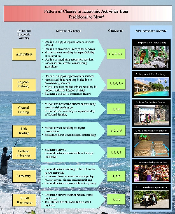
Figure 4: Pattern of Change in Activities from Traditional to New in Sri Lankan Study Site
- Perception of threats to the Coastal Ecosystem based Economic Activities
The respondents were requested to indicate what concern or driver they thought was a major threat in pursuing their occupation. This information was collected for different occupations separately. The aggregated results are shown in Table 12, according to which flooding and sea water intrusion during high tide (80 percent) and storms during rains (75 percent) were the two main threats affecting their occupations particularly agriculture. Coastal erosion was considered the next grave threat (43 percent) while inadequate rainfall was also considered a serious threat (37percent). Other concerns such as storms without rain and flooding during rain were not considered as serious threats. The discharge of waste water from hotels and restaurants to the coasts was the only anthropogenic driver considered as a threat.
Table 12: Percentage respondents who identified a particular concern as a threat
|
Threat |
Percentage response |
|
Natural: |
|
|
Storms during rains |
75 |
|
Storms during other seasons |
10 |
|
Flooding and sea water intrusion during high tide |
80 |
|
Flooding due to heavy rainfall |
20 |
|
Inadequate rainfall |
37 |
|
Coastal erosion and sea approaching closer |
43 |
|
Anthropogenic: |
|
|
Wastewater from hotels and restaurants polluting the coast and the seawater |
60 |
Source: Primary Survey
Coastal storms were identified as a major threat in the fisheries sector (75 percent), while sea water intrusion was identified as a major threat in the fisheries (95 percent), hospitality (55percent) and agriculture (25 percent) sectors. Flooding due to heavy rainfall was considered a major threat in the agriculture sector (83 percent) and to a small extent in the coir industry (15 percent). Both these sectors also considered inadequate rainfall as serious threats, 92 percent and 53 percent, respectively. Coastal erosion was considered as a major threat by fishers (87 percent), hotels (82 percent) and restaurants (86 percent). The waste water discharge from hotels was considered as a threat only by fishers (35 percent). The new economic activities including both 3-wheel vehicle driving and handicraft sales were not affected by any of the natural hazards.
Vulnerability and risk of various economic activities to different threats was determined and shown in Table 13.
Table 13: Vulnerability and risks
|
Threat |
Economic Activity |
||||||
|
Natural |
1 |
2 |
3 |
4 |
5 |
6 |
7 |
|
Vulnerability (Natural Threats) |
|
|
|
|
|
|
|
|
Exposure*Sensitivity |
1.73 |
1.62 |
0 |
2.5 |
0 |
0 |
0 |
|
Vulnerability (Anthropogenic Threats) |
|
|
|
|
|
|
|
|
Exposure*Sensitivity |
0 |
0 |
0 |
0 |
0 |
0 |
0 |
|
Risk (Natural Threats) |
1.5 |
0 |
1.0 |
0 |
0 |
0 |
0 |
|
Vulnerability*Risk (Natural Threats) |
2.3 |
0.001 |
2.0 |
0.001 |
0.001 |
0.001 |
0.001 |
Note: Economic activity 1 refers to agriculture, 2- 3 wheeler driving, 3-coir industry, 4-fisheries, 5-handicraft, 6-hotel industry,7-restuarant
The opinions expressed by the respondents in the Southern coast of Sri Lanka show that the traditional economic activities such as agriculture and fisheries are more vulnerable to natural hazards than the new economic activities such as 3-wheel vehicle driving or handicraft selling. The survey findings showed that the majority of fishers amounting to 86 percent have not heard of climate change and were not aware that this could cause an increasing threat in the future with higher vulnerability to stormy weather conditions, especially to those who venture into the sea in small boats. As an adaptation measure, it is proposed that fishers be encouraged to phase out the use of small boats in preference to large boats which can withstand stormy weather conditions in mid-sea. Intervention of the government is essential by providing the necessary financial assistance possibly through cooperative bodies to acquire large multi-day boats which will serve two purpose – firstly to increase the harvest from off-shore/ deep-sea sources and secondly to reduce the risks faced by fishers in mid-sea during stormy weather conditions.
The fishers also urged that immediate government intervention is required regarding the prohibition imposed by EU, because the majority of fishers who depend on tuna catches suffer severely due to loss of their income. Moreover, attention must be paid in order to control unauthorized fishing by foreign vessels as they exploit the fish stock unsustainably. Restriction of course-net is also a must because it leads to the population depletion being an untargeted fishing method. Enforcing a guaranteed market price for the products, awareness on sustainable exploitation of yield and maintain the required quality standards, subsidies on fuel and other fishing gears, proper loan systems, efficient mechanism to sell their catch are some of suggestions that can be adopted to encourage a greater number of fishers seeking offshore and deep-sea fishing.
V. Concluding Remarks
Field experience show traditional economic activities of coastal communities are moving away from fishery and agriculture. Change is due to declining fish stock, cyclone, storm surges, salt water intrusion, water stress. Change is also due to low income from traditional livelihood, competition for land, pollution load. Demand for tourism, related f policies are creating short term alternative livelihood options. Threats to current coastal economic activities will exacerbate in the region due to climate change.
VI. Acknowledgment
Financial grant received from Asia-Pacific Network on Global Change Research (APN Project reference numbers: ARCP2012-12NMY-ROY and ARCP2013-07CMY-ROY) help in multi-country collaboration, field survey, science-policy workshops. Support in accessing information from various state and central government officials in different departments, academic and research institutions, local community organizations in countries are duly acknowledged.
1. I. J. Bateman, G. M. Mace, C. Fezzi, G. Atkinson, K. Turner, “Economic analysis for ecosystem service assessments”, Environmental and Resource Economics, 2011 Feb 1;48(2):177-218.
2. UNEP, Millennium Ecosystem Assessment Synthesis Report, UNEP, 2005.
3. E. B. Barbier et al, “Coastal ecosystem-based management with nonlinear ecological functions and values”, Science. 2008 Jan 18;319 (5861):321-3.
4. L. Burke et al, Coastal ecosystems. Washington, DC: World Resources Institute; 2001.
5. J. Roy et al, “Coastal Ecosystem and Changing Economic Activities and Vulnerabilities along Chinese and South Asian Coasts” in J. Boonjawat, K. Fukushi, & L. A. Stevenson, Eds., APN Science Bulletin (6). 2016, Asia-Pacific Network for Global Change Research (APN). ISSN 2185-761X.
6. UNEP, Marine and Coastal Ecosystems and Human Well-being Synthesis Report, UNEP, 2006.
7. R. K. Turner, I. Lorenzoni, N. Beaumont, I. J. Bateman, I. H. Langford, A. L. McDONALD, “Coastal management for sustainable development: analysing environmental and socio-economic changes on the UK coast”, Geographical Journal, 1998 Nov 1:269-81.
8. M. L. Martínez, A. Intralawan, G. Vázquez, O. Pérez-Maqueo, P. Sutton , R. Landgrave, “The coasts of our world: Ecological, economic and social importance”, Ecological Economics, 2007 Aug 1;63(2):254-72.
9. W. N. Adger, “Social and ecological resilience: are they related?”, Progress in human geography, 2000 Sep 1;24(3):347-64.
10. R. J. Klein, M. J. Smit, H. Goosen, C. H. Hulsbergen, “Resilience and vulnerability: coastal dynamics or Dutch dikes?”, Geographical Journal, 1998 Nov 1:259-68.
11. W. N. Adger , T. P. Hughes , C. Folke , S. R. Carpenter, J. Rockström, “Social-ecological resilience to coastal disasters”, Science, 2005 Aug 12;309(5737):1036-9.
12. T. F. Stocker , editor. Climate change 2013: the physical science basis: Working Group I contribution to the Fifth assessment report of the Intergovernmental Panel on Climate Change, Cambridge University Press; 2014 Mar 24.
13. T. Gabor, T. K. Griffith , “The assessment of community vulnerability to acute hazardous materials incidents”, Journal of Hazardous Materials, 1980 Oct 2;3(4):323-33.
14. W. N. Adger, “Social vulnerability to climate change and extremes in coastal Vietnam”, World development, 1999 Feb 28;27(2):249-69.
15. K. Smith , “Vulnerability, Resilience and the collapse of society: A review of models and possible climatic applications”, Peter Timmerman, Environmental Monograph No. 1, Institute for Environmental Studies, University of Toronto, 1981, Journal of Climatology. 1981 Oct 1;1(4).
16. R. T. Watson , M. C. Zinyowera , R. H. Moss . The regional impacts of climate change: an assessment of vulnerability, Cambridge University Press; 1998.
17. A. H. Dolan, I. J. Walker, “Understanding vulnerability of coastal communities to climate change related risks”, Journal of Coastal Research. 2006 Jan 1:1316-23.
18. IL&FS, Identification of Tourism Circuits across India, Interim Report prepared for the Ministry of Tourism, Government of India, Gurgaon, Haryana, 2012.
19. S. Hazra, Climate Change Adaptation in Coastal Region of West Bengal, Online at: http://awsassets.wwfindia.org, undated.
20. Government of West Bengal, Action Plan for rehabilitation of sea wall/ sea dyke and prevention of coastal erosion in Digha-Sankarpur-Jalda-Tajpur- Mandarmani area, Irrigation and Waterways Department, Kolkata, undated.
21. C&SD, Census of Population and Housing 2011, Population of Sri Lanka by DS Division, Department of Census and Statistics, Colombo, 2012.
22. CCD, ibid. Table 4.1, p.37, 1990b.