


BISAC NAT010000 Ecology
BISAC NAT045050 Ecosystems & Habitats / Coastal Regions & Shorelines
BISAC NAT025000 Ecosystems & Habitats / Oceans & Seas
BISAC NAT045030 Ecosystems & Habitats / Polar Regions
BISAC SCI081000 Earth Sciences / Hydrology
BISAC SCI092000 Global Warming & Climate Change
BISAC SCI020000 Life Sciences / Ecology
BISAC SCI039000 Life Sciences / Marine Biology
BISAC SOC053000 Regional Studies
BISAC TEC060000 Marine & Naval
This study focuses on rounded fields, or “Maruhata” in Japanese, on the Miiraku Peninsula located in northwest Fukue Island, one of the Goto Islands, Nagasaki Prefecture. Maruhata fields are normally used for agriculture, but they may have multiple functions, for example in preventing floods by temporarily holding water during heavy rains. We conducted a field survey at a three-tiered Maruhata field in the Take District in Miiraku in to measure its latitude, longitude, and elevation. The presence of Maruhata fields smooths out the inclined plane and offers a flood prevention function by retaining water within during heavy rains and ameliorate flows by breaking the gradient. In addition, Maruhata fields have a function to prevent mud and soil to flow into the sea and reduce pressure on the fishing ground. We conclude that Maruhata fields have a disaster prevention function owning to their topographic features in addition to their function as agricultural fields.
Maruhata fields, rice terraces, disaster prevention, green infrastructure, Goto Islands.
I. INTRODUCTION
・ Background of this study
Floods can occur easily in Japan because many areas are characterized by the steep topography and the rain will flow through the river at a stretch. Under such conditions, people have exercised ingenuity on regional characteristics and put efforts to use water while reducing the damage from it [1]. An example includes rice terraces. It is said that rice terraces have multiple functions other than such a conventional role as food productions. Other functions include disaster prevention such as water retention, flood control, and soil erosion prevention and as a conservation of ecosystems and cultural values of the landscapes [2] [3] [4] [5]. In recent years, these functions came to attract attention and the conservation of rice terraces became active in many places in Japan, although rice terraces are regarded as an inefficient production method. Rice terraces seem to be inefficient, but it is thought that, actually, it is a perfect way for people to utilize the land and water source.
This study focuses on rounded fields, or “Maruhata” in Japanese, on the Miiraku Peninsula located in northwest Fukue Island, one of the Goto Islands, Nagasaki Prefecture because I think that “Maruhata” may be one of the methods for the utilization of water which is deeply rooted in the local culture and environment.
・ Characteristic of the study areas
The Goto Islands (literally, Five Island Archipelago) are located at the westernmost tip of Kyushu, belonging to Nagasaki Prefecture and stretch approximately 80km southwest from the northeast. The Goto Islands have five big main islands such as Fukue Island, and more than 140 smaller islands. In addition, most of the Goto Islands belong to the Saikai National Park and have rich natural settings characterized by the naturally developed beaches, eroded banks, and ancient volcanic features. Fukue Island is the largest within the archipelago and is proud of its beautiful nature. It is also the center of politics, economy, culture, history, and tourism within the Goto Islands. Fukue Island has a ria coast developed on its east, and its 4 peninsular plateaus are characterized by a various and complicated geomorphologic features built by basaltic volcanoes and lava flow. In this study, we focused our investigations on one of the peninsulas, the Miiraku Peninsula, located on the northwest of this island (Fig. 1). This peninsula is a basaltic lava plateau formed by a shield volcano, Kyonotake. Due to its geological settings, the quality of soil is not too suitable for the cultivation and the wind is easy to pick up the soil away because of the gentle topography peculiar to a shield volcano. That is why people on this peninsula were troubled for a long time by wind damage and damage from salt breeze. Therefore, they plant windbreak forests in most fields to reduce the influence on farm produce [6] [7].
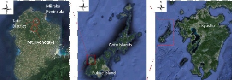
Fig. 1. Miiraku Peninsula, Goto Islands. Mt. Kyonotake is located in the north of the Peninsula. (Source: Google Earth)
・ Characteristics of Maruhata fields
The fields in Miiraku are called “Maruhata” or rounded fields because they are rounded. It is said that the reason for their rounded shape is because of the traces of plowing by horses and cows in the old days. They grow potatoes, wheat, and the grass on these fields. In Japan, a lot of small, protean farms are transformed into large-scale farms; however, the rounded fields still remain today in Miiraku. The local farmers’ agreement for the improvement of the agricultural infrastructure was based on the premise that these traditional farms be kept intact. Maruhata fields that have been inherited in this way are rare nationwide and it can be said that these are precious farming cultural heritage in Miiraku area. In addition, the windbreak forests in Maruhata fields are a unique tradition in Miiraku. The fields are surrounded by a stonewall, and on its base evergreen trees, such as Camellia japonica, are planted. This is to cope with the climate such as the monsoon from the north and northwest during the winter months in the Goto Islands. The necessity for the windbreak forests is further related to the topography in the area. The reason is because the wind is easy to blow over the gentle topography peculiar to a shield volcano with nothing to stop its force. Furthermore, the windbreak forests serve as a cash crop. The camellia oil is extracted from the fruit of the camellia, and is nationally famous as a specialty product of the Goto Islands. It also contributes to the regional economy.
Maruhata fields have side ditches tracing their circumference. Both sides of these ditches are protected by stonewalls; on the bottom, the soil and stones are laid down, that are then covered by a light deposition of fallen leaves. Other than Miiraku, Maruhata fields remain in Tomie, on the same island. However, most of the fields on this island turned into linear fields. Therefore, Maruhata fields are becoming rare on Fukue Island, and they reflect the reminiscence of the beautiful landscape of the ancient times (Fig. 2).
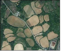
Fig. 2. Maruhata fields in Miiraku. (Source: Google Map)
・ The purpose of this study
Maruhata fields in the Miiraku Peninsula may have multiple functions, just like rice terraces discussed above; they must be the most suitable fields to utilize the land and water for the local landscape. Maruhata fields are normally used for agriculture, but they may have other functions, for example, to prevent floods by temporarily holding water during heavy rains. Therefore, in this study, we conducted a field survey and analyzed the geographical features with the geographic information system “ArcGIS”. We then evaluated whether the structure of Maruhata fields has any functions to prevent or reduce disasters from the aspect of the topographic features.
II. INVESTIGATIVE
・ Topographical survey of Maruhata fields in the Take district of Miiraku
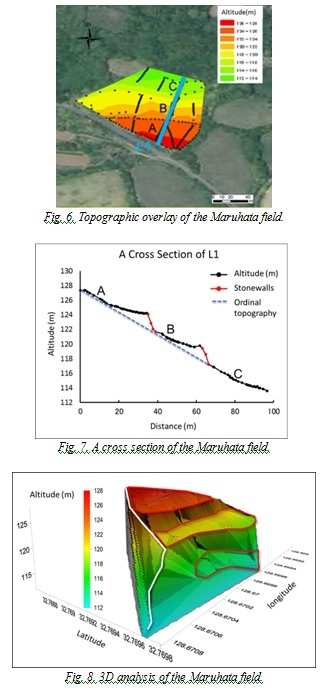
The subjects of this survey are three-tiered Maruhata fields in the Take District of Miiraku (Fig. 3). Between each tier of a Maruhata field is reinforced by stonewalls, giving it the appearance of a rice terrace. We conducted a field survey at this Maruhata field with a surveying rod, RTK-GPS and Total Station. We then expressed the obtained data such as latitude, longitude, and elevation through ArcGIS; furthermore, we put the data on top of one another with an aerial photo and produced an image to reflect the altitude of the Maruhata field. We put line L1 through three steps of the Maruhata field and made a cross section of L1. Next, in order of altitude, each step was segmented into A, B, and C, and we evaluated each gradient. In addition, we conducted a 3D analysis with “Surfer”.
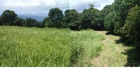
Fig. 3. Maruhata fields on which a field survey conducted.
・ Investigation of form and gradient of the Maruhata fields on Miiraku
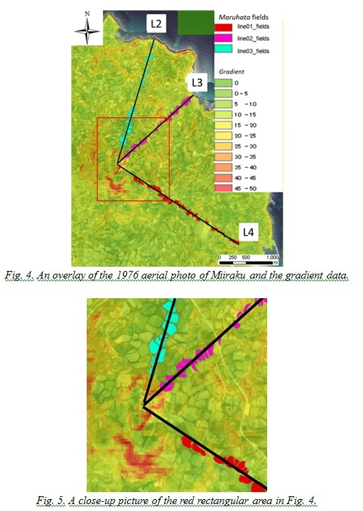
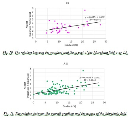
We overlaid the gradient data of the whole Miiraku Peninsula on the aerial photo using ArcGIS. The result shows that high gradient was displayed in red, and small in green. On this occasion, we used an aerial photo taken in 1976. The reason is because we needed to have a clear imagery of the forms and size of the Maruhata fields from the space. In aerial photos after 1976, it became increasingly difficult to tell the shape of the Maruhata fields because many of them became unmanaged or abandoned, and the overgrowth of the surrounding windbreak forests and plants are obscuring the shape of the fields. Furthermore, the purpose of this study is to understand the relationships among the shape, size, and the gradient of the Maruhata fields. For this we used the aerial photos taken in 1976 to get accurate pictures for our analyses because no alterations took place on the fields since. Then we drew lines L2, L3, and L4 from the Mt. Kyonotake mountaintop towards the sea. L2 goes along the Maruhata fields we conducted a field survey on, L3 goes along the line with relatively many steeper gradients, and L4 goes along the line with many gentler gradients (Fig. 4 and Fig. 5, respectively). We measured the area, minor axis, major axis, and gradient of each Maruhata field on these three lines on ArcGIS. Additionally, the gradient was calculated on ArcGIS by using 5m mesh altitude data available from the Geographical Survey Institute and the value was obtained. The minor axis defined it as the width that became shortest through the center of gravity of the Maruhata fields. The major axis defined it as the width that became the longest through the center of gravity of the Maruhata fields. We summarized a gradient and an area, a gradient and an aspect (major axis / minor axis) in each graph for 30 Maruhata fields on L2, 33 of them on L3, 34 of them on L4. Furthermore, we made a similar graph for all 97 Maruhata fields on L2, L3 and L4 in total. In addition, in all graphs, we performed a regression analysis. We set a level of significance with 1% because there were too many variables for the regression analysis.
III. The Result
・ The result of the topography survey of the Maruhata fields
We compiled the altitude data of the Maruhata fields that we conducted a field survey on with GIS (Fig. 6). In Figure 6, the red indicates the areas with high altitudes and the green, low altitudes. This made it clear that the Maruhata fields are not completely flat and leveled, but are gently sloping. Figure 7 shows a cross section of the line L7. Here, the black line represents the altitudes of Maruhata fields and the red one shows that of the stonewalls between steps. In addition, blue one represents hypothesized altitudes when there is no Maruhata fields. Based on a 3D analysis, we created an image of the structure of a Maruhata field (Fig. 8). Hence, it became clear that because of the presence of the Maruhata field and stonewalls, the slope of the original topography became gentler. In addition, after quantifying a gradient in each segment A, B, and C of three steps, the gradient became 1/10 in all steps, showing that a gradient became clearly gentler. This is backed up by the numerical value of the original slope being 14/100.
・ The result of relations between the form and gradient of the Maruhata fields
a) The relation between gradient and area
The relations between the gradients and the area of all Maruhata fields on L2, L3 and L4 are expressed in Fig. 9. The result shows that the area tended to be larger when the gradient was small, and vice versa. In addition, it shows that and there was a significant difference (P<0.01).
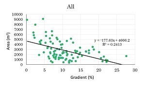
Fig. 9. The relationship between the overall gradient and the area of the Maruhata field.
b) The relations between the gradient and aspect
The relations between the gradient and the aspect (major axis / minor axis) in L3 and all are shown in Fig. 10 and Fig. 11, respectively. The result shows two tendencies. One is that there is a relation between the gradient and the aspect of the Maruhata fields. The other is that when the gradient becomes smaller, the aspect of that approaches to 1, and when the gradient becomes larger, the aspect gets away from 1 and the value increases. The value of P <0.01 indicates that there was a significant difference.
・ Topography of the Maruhata fields
The three-tiered Maruhata fields were conducted for a field survey, and it was found that because of the alternative placement of Maruhata fields and stonewalls, the gradient became gentler than that of the original topography. If there is no Maruhata fields, it is expected that heavy rain will cause a massive flow from the mountains through the residential area, and in some cases, debris flow can be triggered to give the area severe damages. It may be said that Maruhata fields and stonewalls may carry the role to reduce erosion of the soil with a function to prevent flood by damping force of water flowing from the higher elevation. In addition, they have a function to prevent mud flow into the sea. In general, the development of the farmland is regarded as the cause of surface soil erosion and the outflow of fine sediment into the sea through a river, often giving a pressure onto the fishing ground of the coastal fishery. However, it is thought that Maruhata fields could reduce surface soil flowing out from the land by stopping the erosion of soil to its minimum. In addition, stonewalls may also play a role to reduce erosion and soil outflow.
・ The relation between the form and gradient of Maruhata fields
a) The relation between the gradient and area
On L2, L3, L4 and all, there is a common tendency that when the area of Maruhata fields is large, the gradient is small, and when the area becomes smaller, the gradient becomes steeper. Therefore, we have concluded that there is the closed relations between the gradient and the area of Maruhata fields in Miiraku.
b) The relation between gradient and aspect
As shown in Fig. 11, there is the tendency that the aspect of Maruhata fields approaches to 1 when the gradient is large, and the aspect becomes big when the gradient is small. It expresses that when a Maruhata field becomes rounder in form, the length of the major axis becomes almost the same as the minor axis, so that the value of the aspect nears 1. Hence, in all of the graphs, it was found that the larger the gradient is, the rounder the form of Maruhata fields becomes and the opposite is true as well.
In contrast, as the result of the regression analysis shown in Fig. 10 indicates, the P value of <0.01 could mean that there is no relations between the gradient and form of Maruhata fields. This may result from the fact that when the line L3 was set, the area with a steeper gradient was chosen intentionally, and while in comparison, the lines L2 and L4 were drawn on the area with much gentler gradients. It may be possible that the regression analysis error was derived from the biased data to choose selectively steeper gradient for the line L3. The lack of gentler gradients might have caused the error. With this taken into account, we will have to devise a better way to set the lines in future.
Based on our study, we have concluded that there may be relations between the gradient and Maruhata fields in Miiraku; the slender, elliptic Maruhata fields have steeper gradients and rounded ones yield gradients that are gentler. Thus, we have concluded that the presence of small and slender Maruhata fields makes the steep gradient of the mountain gentler. As mentioned above, this is related to the Maruhata field having possibilities to take a role to prevent the outflow of a flood and a sand soil in the case of a heavy rain. Furthermore, we have concluded that this is the wisdom of the locals in Miiraku to use the land optimally given the characteristics of the topography.
V. CONCLUSION
In this report, we gathered the following information by analyzing the topography from the field survey conducted on the Maruhata fields on the Miiraku Peninsula, Fukue Island, Goto Islands. First, the presence of the Maruhata fields is responsible for the gentler gradient on otherwise steeper slope of the untouched topography. It is assumed that this is effective in reducing the soil erosion and force of the flowing water from the mountain in case of heavy rain. In addition, it seems that the effect of reducing soil erosion prevents muddy water to flow into the sea and decreases the pressure on the coastal fishery. Second, it is possible that when small and slender-shaped Maruhata fields are concentrated on a steeper gradient, they can make it gentler, preventing floods and soil erosion.
In conclusion, it is assumed that the reason why Maruhata fields still remains and has been used is not because they have left undeveloped by modern society, but because they are the product of the wisdom of the local people who have been using their land and water efficiently and effectively for centuries. It was their way of living with nature, and it has been proven to be the most suitable for their environment. Further studies are necessary in order to evaluate the multiple functions in detail. In recent years, “Green Infrastructure”, which is the infrastructure utilizing the power of nature, has attracted the attention [8] [9]. We believe that Maruhata fields can contribute to it to prevent or reduce disaster, and moreover, to preserve local natural conditions and a traditional way of living. In considering the sustainable use of natural resources on coastal zone, we should pay attention to not only the sea area but also the land area such as this traditional land use.
VI. ACKNOWLEDGEMENT
We are deeply grateful to Hiroyuki Kawajiri, Yoshito Sakurai, and Katsuyuki Nagaya, residents in Goto Islands, who offered continuing support and constant encouragement. K.I. would also like to thank Dr. Iwasaki for the review of this paper in English. Finally, this study was made possible by the grant from the Ministry of the Environment.
1. Prime Minister’s Official Residence, “Basic Plan on Water Cycle”, <https://www.kantei.go.jp/jp/singi/mizu_junkan/pdf/honbun.pdf>
2. M. Nakashima, “Rice Terraces in Japan”, Kokin Shoin, pp. 83-129, 1999.
3. MLIT West Chuubu Region Station Toyohashi River Office, “Evaluations on the Multiple Functions of Forests and Fields”, <http://www.cbr.mlit.go.jp/toyohashi/kaigi/yahagigawa/kondan/kondan/05/shiryo/01_3.html>
4. NPO Rice Terraces Network, “Functions of Rice Fields”, <http://tanada.or.jp/tanadadate/function/>
5. Kamikatsu Town Board of Education, “Rice Terraces Cultural Landscape Preservation Plan of Kashihara”, 223 p., 2009.
6. Miiraku, “Local History of Miiraku-cho”, Miiraku, 723 p., 1988.
7. Miiraku Local History Preparation Committee, “Local History of Miiraku-cho”, Miiraku, 344 p., 2004.
8. T. Nishida, and Y. Iwaasa, “Towards Development of Japan’s Green Infrastructure: Ecosystem-based Solution for Disaster Risk Prevention and Reduction, Social Capital Improvement, and National Land Management”, Quarterly Study of Policy and Management, vol. 1, pp. 46-55, 2015.
9. Kajima Construction Co., Inc., “What is Green Infrastructure?”, <http://www.kajima.co.jp/tech/green_infra/about/index.html#pagetop>