


Sankt-Peterburg, St. Petersburg, Russian Federation
BISAC NAT010000 Ecology
BISAC NAT045050 Ecosystems & Habitats / Coastal Regions & Shorelines
BISAC NAT025000 Ecosystems & Habitats / Oceans & Seas
BISAC NAT045030 Ecosystems & Habitats / Polar Regions
BISAC SCI081000 Earth Sciences / Hydrology
BISAC SCI092000 Global Warming & Climate Change
BISAC SCI020000 Life Sciences / Ecology
BISAC SCI039000 Life Sciences / Marine Biology
BISAC SOC053000 Regional Studies
BISAC TEC060000 Marine & Naval
The easternmost part of the Gulf of Finland is characterized by intense coastal processes where erosion dominates. Onshore laser scanning of a beach surface of three coastal zone segments of the Kurortny District, St. Petersburg was carried out during the process of realisation of the CliPLivE project and coastal monitoring investigated by VSEGEI and “Mineral” company. One of the goals of the CliPLivE project was a prediction of coastal evolution by 2100 year based on retrospective analysis of the last century remote sensing data. The average annual range of coastal transformation was used for the mathematic modelling of beach profile changes. The model takes into account changes of sea level and possible increase of storm events occurrence. The onshore laser scanning was carried out each summer since 2012. After series of storms in 2015 the repeated scanning was carried out in December. It gave an opportunity to calculate volume and area of redeposited sand during the last storm that shows that a part or almost all sand material from eroded foredune was deposited in a middle part of the beach. This material forms an onshore sand bar in front of a new formed erosion escarpment. The comparison of the beach relief elevation models of 2012 and 2015 shows that another part of sand (up to 30-40% of volume of all mobilized beach sand) was washed out from the beach to offshore. The data of onshore laser scanning confirmed that the mathematical model of prediction coastal changes works.
coastal erosion, beach deformation, storm events, sediment loss, numerical modeling, Baltic Sea.
- Introduction
Results of A.P.Karpinsky Russian Geological Research Institute (VSEGEI) research and monitoring have shown that northern coastal zone of the Gulf of Finland strongly affected by erosion processes, caused by regional geology, geomorphology, tectonics and hydrometeorological conditions. Upper part of coastal geological sequence consists of easily erodible Quaternary deposits represented mainly by Holocene marine sands and Late Pleistocene sandy and clayey loam of glacial origin. Due to high content of coarse-grained material (boulders, cobbles) washed out from glacial moraine a belt of stones of various size is formed on the beachface and in the nearshore bottom, which in turn causes sediment deficiency and reduces ability for self-restoring of the coastal zone after extreme storms [1].
Annual coastal monitoring of the Eastern Gulf of Finland, carried out by VSEGEI since 2000, using regular field observations, levelling, ground-penetration radar profiling and sediment sampling, has shown that the most heavy damage of the sandy beaches and dunes is observed after strong western – south-western storms, accompanied by high storm surges level [2]. Maximal rate of erosion escarpment retreat (about 5 m after one storm event) was fixed in November and December of 2011 [3]. Coastal monitoring reveals acceleration of erosion processes during last ten years because of higher frequency of extreme storms. The strongest storms are observed in the Gulf of Finland during winter seasons. In the previous years ice cover prevented coasts from erosion, but warmer winters of recent time caused decrease of stable ice development in the Eastern Gulf of Finland. Development of effective coast protection system is required quantitative assessment of coastal transformation and volume of loss of sediment material under impact of severe storms.
The first attempt of such assessment was done in the frame of the Russian-Finnish project “Climate Proof Living Environment” (СliPLivE) of South-East Finland – Russia ENPI CBC 2007 – 2014 Program. In 2012-2013, the laser scanning of a beachface was carried out along 500 m of the shoreline in Komarovo village. Measurements were repeated twice – in October 2012 (during period of beach stabilization) and in November 2013 (right after several strong storm, e.g. so called “Saint Juda” hurricane). GIS analyses of received result has shown that during storm sand material is actively removed from the backshore; erosion escarpment in the foredune is forming and quickly retreating. Part of eroded sand at the same time is accumulating on the beachface, but the other part is transporting offshore so the total sediment balance by the end of the storm is negative. Volume of sediment loss reached 459 m3 (about 90 m3 from 100 m of beach) (CliPLivE Report, 2014).
Using of laser scanning was continued in frame of the project of General Coast Protection Plan development, undertaken by State Geological Enterprise “Mineral” together with VSEGEI specialists. In 2015 laser scanning was organized along three coastal segments, characterizing sandy beaches of different shoreline directions. In Komarovo village beach, laser scanning was undertaken within area of the previous study. For all study areas measurements were carried out in summer time (August 2015), and after the extreme storm of 5-7 December 2015, when the wave heights in open part of the Gulf was 3-4 m (meteo.pl), wind speed (in gusts) reached 23 m/s. Due to warm autumn weather the ice cover in the Eastern Gulf of Finland was absent, so the beaches, dune belt and coastal infrastructure were seriously damaged.
The main goal of the reported study was to establish volumes of eroded, removed and redeposited sand material over the storm surge of 5-7 December, and to verify mathematical model of beach profile deformation. Compiled detailed 3D GIS models of coastal relief, based on high-resolution geodesic survey, allowed to receive a highly reliable data about beachface transformation under the extreme storm impact and quantitative assessment of erosion volumes and sediment loss.
- Materials and methods
Within three beach areas of the Kurortny District (St. Petersburg) a terrestrial laser scanning (TLS) survey was carried out before and after storm events of December 2015. TLS technology allowed calculating a volume of transported beach sand. The data of relief transformation is a base for simulation of parameters of the last storm culmination. The 3D laser scanning covered the beach surface and a first dune ridge or an erosion escarpment. The length of a coastline scanning is about 200 m in Komarovo village, 190 m – in Repino village and 150 m – in Serovo village (Fig.1). The laser scanning data were used only on the beach surface without vegetation cover that gave opportunity to exclude calculation errors.
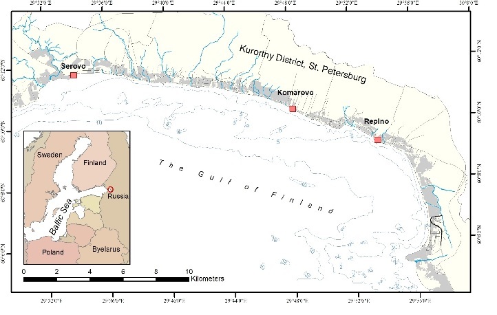
Fig.1. Location map of the study areas of terrestrial laser scanning (red squares) along the eastern coast of the Gulf of Finland (Baltic Sea) within the Kurortny District of St. Petersburg.
Terrestrial laser scanning. Works were carried out by “Alpha-Morion ltd.” using the terrestrial laser scanner “RIEGL VZ-400” (Austria) from twelve points of standing (scan positions). Geodetic reference was made in the local coordinate system 1964 (SK64) and in the Baltic System of Heights 1977 with the help of such geodetic equipment as the Trimble R8 and Javad Legacy-E satellite. Post-processing was performed in “Pinnacle” program. Horizontal and vertical snapping of the position marks was made by a total station “LEICA TS06 Ultra (2")” (Austria).
Methods of data processing. Cloud of XYZ points was imported to ArcGIS software. Gridding of XYZ data allowed to create the high-resolution (cell size of a grid is 10 cm) digital elevation model of the beaches for the next surface analysis. The calculation of beach surface deformation was executed with the “Cut Fill” tool as a difference between beach surface of December 2015 and August 2015. The result was a grid, which contained volume of data of erosion and accretion areas on the beach.
Numerical modeling. The model CROSS-P tested in the coastal zone of the Gulf of Finland [4], [5] was used for calculation of the probable parameters of the storm and coastal profile changes. The model can both reproduce the erosion process of the sandy beach, and to reflect the main features of accumulation of a coastal profile. Coastal profile modelling allowed to estimate range of coastal profile changes during the storm event and to calculate the volume of washed out sand material from the beach during the low wave activity. In addition, the model considers the overtopping of the first dune during the storm. Types of profiles predicted by the model are consistent with the known empirical criterion.
- Results
Terrestrial laser scanning
Komarovo village. Study area can be subdivided into two parts. The eastern part is characterized by significant anthropogenic impact on beach morphology and presence of numerous recreation constructions (recreation area “Beach Paradise”). Western part of the study area is less disturbed. The beach is more than 30 m width; it includes the beach ridge and the berm. In the backshore, the foredune (2–2.5 m height) is observed. These parts of the study area are separated by the small river.
As the beach is heavily eroded [6], [1], within the boundaries of the private recreation area located in the eastern part of the study area the coastal protection measures have been carried out (e.g. removing of big boulders with short groins or breakwaters construction, artificial beach nourishment etc.). Coastal protection as well as construction of wooden recreation facilities have been executed without taking into account coastal dynamic processes and lead to beach degradation.
TLS area where comparison of relief surface after survey of August and December 2015 using 3D numerical model is 4020 m². Results of calculation have shown that after storm of 5-7 December 2015, along the segment of the sandy beach (200 m length) 920.3 m³ of sand was removed. Coastal escarpment and foredune slope and crest (including coastal terrace surface behind the foredune) were most intensely threatened by erosion. Area of sand redeposition was located in the central part of beach profile, where slightly dome shaped surface (or ridge) was formed. Total volume of eroded sediment material was 464.5 m³, volume of deposited material – 455.8 m³ (Table 1), nonrecoverable sediment loss – 8.7 m³ (or about 2% of material, mobilized during the storm). Length of sand escarpment retreat within the anthropogenically disturbed part of the study area was 2.5 m (Fig. 2), while foredune slope in the adjacent (“natural”) part of the coast was shifted 1.5 m landward, forming active escarpment.
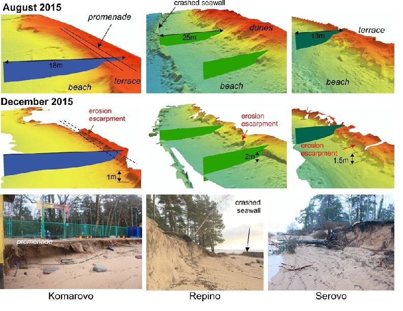
Fig.2. Photos of last storm effects and 3D numerical model of beach areas with cross-section for August 2015 and December 2015
Analyzing longer period, we can conclude that since summer 2014, coastal escarpment within the boundaries of the recreation area “Beach Paradise” retreated 3.5 m; since summer 2012 – 10 m landward. Comparative analyses of numerical relief surfaces, received in 2012 and 2015, was carried out for the area of 4154 m² (260 m of beach). During this time 1182 m³ of sand was removed. Spatial distribution of erosion and accretion areas is the same as for one storm – intense erosion of backshore, escarpment and foredune (Fig. 3) and deposition in the central part of the beach. Total volume of eroded material in the period 2012-2015 is 777 m³, volume of redeposited sand – 405 m³. Sediment loss reached 372 m³ (about 48% of sediment volume, removed during this time).
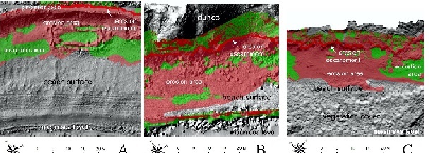
Fig.3. Shaded relief of beach surfaces with last storm effect: erosion area (red), accretion area (green) and position of the erosion escarpment of the last storm events. A – Komarovo village; B – Repino village; C – Serovo village.
Repino village. Beach width of the study area is about 40 m. On the surface of the beach ridge and nearshore bottom boulders and pebbles dominate; the berm surface is smooth, in the backshore the erosion escarpment on the steep slope of relict sand terrace. Height of the terrace with the dune complex is up to 10 m a.s.l. On the terrace surface, composed on unconsolidated sand sediments, the dunes are developed. In the central part of the beach berm, remains of broken concrete seawall are located. In the southeastern part of the study area the coast is strengthen by the sloped seawall from granite blocks and boulders (coast protection structures of beginning of the 20th century). In the nearshore there are several boulder groins, perpendicular to the shoreline. The distance between the groins is about 50 m (Fig. 2). Study area is a popular recreation zone, experienced during summer time significant anthropogenic load.
Area of repeated laser scanning in August and December 2015 within described study area is 4460 m². Removed sand volume is 422.2 m³ (along 190 m of shoreline). The foot of erosion escarpment, formed after the December storm, is located at the height 3 m a.s.l. Surface of dunes located higher erosion escarpment was not touched by wave impact, sediments were removed downslope by gravity processes. Considering large area of the slope surface, the volume of removed sand here is relatively small – about 25.3 m³ (or 6% of total volume of removed sediments). Most probably the main reason of sand transport here is not wave action, but landslides from the upper part of the slope. The wave impact zone is limited by the slope foot and beach berm.
Most part of the backshore near the the slope foot (with local exception of accumulation caused by slope processes) is an area of intense erosion. Part of eroded material was deposited in the nearshore – between the shoreline and remains of broken sand protection structures, worked as an artificial barrier for self-restoration of the beach after the storm. Volume of removed sand within the study area is 299.6 m³, volume of redeposited sediments – 122.6 m³ (Table 1). Total sediment loss reached 177 m³ or about 59% of removed sand volume. Erosion escarpment was shifted landward for the distance 2.5–4 m, besides the new escarpments were formed within previously stable parts of the terrace slope.
Table 1. Volume of sediment material removed during the storm of 5-7 December 2015
|
Komarovo village |
Repino village |
Serovo village |
||||
|
Coastal line length |
200 m |
190 m |
150 m |
|||
|
Removed |
464.5 m³ |
100% |
299.6 m³ |
100% |
189.1 m³ |
100% |
|
Redeposited |
455.8 m³ |
98% |
122.6 m³ |
41% |
80.6 m³ |
43% |
|
Sediment loss |
8.7 m³ |
2% |
177 m³ |
59% |
108.5 m³ |
57% |
Comparison of TLS survey results, carried out in August 2015 and December 2015 for 3600 m² of beach, has shown that along 160 m of shoreline 355 m³ of sand was mobilized. 287.1 m³ of sand was eroded, 62.9 m³ - redeposited. Sediment loss volume reached 224.2 m³ (about 78% of total removed sand volume).
Serovo village. Sandy beach of Serovo village is represented by the narrow (13–15 m) beach ridge, adjacent in the backshore to erosion escarpment up to 2 m height. Terrestrial laser scanning was undertake here three times – in August 2014, August 2015 and December 2015. Comparative analyses of results of the summer 2014 and 2015 survey revealed very stable character of the study beach with minor changes of relief. The changes were caused by quick growing of water plants in the nearshore and beach ridge. By August 2015, the nearshore area was totally covered by sea grass and low bushes.
Area of comparative analyses of TLS surveys of August 2015 and December 2015 is 2050 m². Along 150 m of beach, overgrown by water plants in the nearshore, 269.7 m³ of sand was mobilized. Similar to the previous case studies, the most intense erosion occurred in the backshore and the central part of the beach ridge (Fig. 3 C). Due to presence of water plants and bush vegetation, partly blocked erosion processes, in the southwestern part of the study area local accumulation of sand material took place. Nevertheless vegetation does not prevent erosion - as a result of December storms 189.1 m³ of sand was removed (Table 1), 80.6 m³ – redeposited. Nonrecoverable sediment loss volume reached 108.5 m³ (about 57% of all material, removed during the storm). Distance of the erosion escarpment shift in landward direction was 0.8–1.3 m. The rate of escarpment retreat was different within the frames of the study area – with maximal erosion intensity along slightly advanced part of the shoreline.
Coastal profile modelling
It is important to ascertain the parameters of the December storm in the studied coastal area (eastern Gulf of Finland). Unfortunately, the water level and wave heights were not measured during the storm period. However, it is possible in principle to estimate the characteristics of interest by using the modelling of storm-induced bed deformation. Commonly the coastal modelling is aimed at prediction of changes in a coastal profile for the known wave conditions. In a given case, we try to solve the alternative problem – to define the storm parameters taking into account the fixed changes of a beach profile.
Dune erosion and recession are mainly observed during the peak of storm impact when the maximal water level is reached. Hence, this phase of storm is our special interest. First of all, we assume that wave heights and periods during the peak of the December storm could be close to typical parameters of severe storms fixed in former times in the eastern Gulf of Finland [7], [4], [5]. With this assumption, the problem is simplified. Now the modelling of bed profile changes is only required for various heights of storm surge η and different durations tm of the storm maximum. The required values of η and tm would correspond to condition of the closest coincidence of computed and observed displacements of the dune profile.
Calculations take into account that due to turn of a coastline contour the waves come to Serovo village with a greater angle relatively to the shore normal than to villages Komarovo and Repino. Comparison of modelling results with observed data is shown at Fig. 4. Despite some deviations in the lower part of a beach, calculations reproduce recession of a foredune satisfactorily. Thus based on the obtained results, one can characterize the storm peak in December 2015 by approximate figures given in the Table 1. Wave parameters (significant heights and spectral peak periods) refer to the open part of the Gulf of Finland.
.jpg)
It is well known, that the height of storm surges in the Gulf of Finland increases towards the Neva Bay. Hence, the maximal water level in Komarovo and Repino should be higher than in site Serovo. This trend is also seen from the Table 2.
Table 2. Probable parameters of the storm peak in December 2015 in the Eastern Gulf of Finland
|
Coastal region |
Wave height, m |
Wave period, s |
Max. water level, m |
Duration, h |
|
Komarovo and Repino |
1.6 |
5.4 |
2.2 |
2 |
|
Serovo |
1.6 |
5.4 |
2.0 |
2 |
- Conclusions
In the framework of the coastal zone monitoring of the Eastern Gulf of Finland, carried out by VSEGEI, the quantitative assessment of sandy beach storm deformation, using repeated surveys by terrestrial laser scanning was undertaken in 2015. Laser scanning was organized in summer time (August 2015) and right after severe autumn storm surges (December 2015). Within all studied areas, December storms caused an intense erosion of backshore coastal forms (foot and slopes of coastal escarpments and dunes). The distance of erosion escarpment retreat varies from 0.8 to 4 m. Part of eroded from backshore material is redeposited in the central and nearshore parts of the beach, forming smooth horizontal berm or beach ridge. Because of these processes, by the end of storm the volume of total sediment loss within two study areas reached 57–59 % of removed material. Within the third study area (Komarovo beach), volume of sediment loss is significantly smaller (2% of mobilized material).
Recalculation has shown, that within Repino beach sediment loss volume was 0.9 m³ from one meter of beach length, in Serovo beach – 1.4 m³, in Komarovo beach – 0.04 m³. It is noteworthy, that comparison of terrestrial laser scanning results for the same area for longer period (2012-2015), revealed sediment loss volume of 0.47 m³ from every meter of beach length.
Presented research supported the general understanding of mechanism of coastal erosion and beach profile deformation in the Eastern Gulf of Finland under the extreme storm impact and allowed to receive its quantitative assessment.
1. D. Ryabchuk, A. Kolesov, B. Chubarenko, M. Spiridonov, D. Kurennoy and T. Soomere, “Coastal Erosion Processes in the Eastern Gulf of Finland and Their Links With Geological and Hydrometeorological Factors,” Boreal Env. Res., 16 (suppl. A), pp. 117-137, 2011.
2. Information Bulletin on the State of Geological Environment of the Coastal Areas of the Barents, White and Baltic Sea in 2013, Ed. O.V. Petrov, A.M. Lygin. St. Petersburg, VSEGEI, 136 p., 2014, in Russian.
3. H. Tonisson, Ü. Suursaar, S. Suuroja, D. Ryabchuk, K. Orviku, A. Kont, A. Sergeev, R. Rivis, “Changes on Coasts of Western Estonia and Russian Gulf of Finland, Caused by Extreme Storm Berit in November 2011,”. IEEE/OES Baltic International Symposium, Present and future. Climate change research, ocean observation and advanced technologies for regional sustainability, Klaipeda, Lithuania, pp. 1-7, 2012.
4. I.O. Leont’yev, D.V. Ryabchuk, A.Yu. Sergeev, “Modeling of Storm-Induced Deformations of a Sandy Coast (Based on the Example of the Eastern Gulf of Finland),” Oceanology, v. 55, № 1, pp. 131-141, 2015.
5. I.O. Leont’yev, D.V. Ryabchuk, A.Yu. Sergeev, O.A. Kovaleva, “The Forecast of Coastal Recession in the Eastern Gulf of Finland for the Twenty-First Century,” Oceanology, v. 55, № 3, pp. 434-440, 2015.
6. D. Ryabchuk, V. Zhamoida, A. Sergeev, O. Kovaleva, E. Nesterova, L.Budanov, “The Coastal Erosion Map for Different Climate Change Scenarios. Compilation - methodology and results,” Climate Proof Living Environment (CliPLivE) Final Report (SOUTH-EAST FINLAND - RUSSIA ENPI CBC 2007 - 2014), St. Petersburg, 28 p. 2014, http://cliplive.infoeco.ru.
7. L.K. Barkov, “Lithodynamic Processes in the Coastal Zone of the Western Part of the Gulf of Finland from c. Lautaranta to c. Dubrovsky,” Proc. RGS, v. 123. is. 1, pp. 60-67, 1991, in Russian.