


BISAC NAT010000 Ecology
BISAC NAT045050 Ecosystems & Habitats / Coastal Regions & Shorelines
BISAC NAT025000 Ecosystems & Habitats / Oceans & Seas
BISAC NAT045030 Ecosystems & Habitats / Polar Regions
BISAC SCI081000 Earth Sciences / Hydrology
BISAC SCI092000 Global Warming & Climate Change
BISAC SCI020000 Life Sciences / Ecology
BISAC SCI039000 Life Sciences / Marine Biology
BISAC SOC053000 Regional Studies
BISAC TEC060000 Marine & Naval
The plot of study is Cheboksary and its suburbans and located on the joint of two landscape zones: a forest zone and a forest-steppe zone. The border between the zones goes along the Volga River, which establishes favourable environment for recreation. There has been observed slope type of areas on the right bank of the Volga River of the Cheboksary and Kuybyshev Reservoir. It has 3º and more incline, with washed-off soil and broadleaved woodland (relict mountainous oak woods), subjected to considerable land-clearing. In the immediate bank zone of the Volga River, where abrasive-soil-slipping and abrasive-talus processes mostly develop, the main types of natural areas have been marked out: 1) Abrasive landslide cliffs at the original slopes of Volga Valley of 60º steepness, more than 15 m high, with permanent watering as a result of underground waters leakage; 2) Abrasive cliffs of terraces above flood-plains of 2 m high; 3) Abrasive cliffs of original slope of the valley of the river Volga of 2 m high, with distinctive abrasive niches in the lower part of the slope or temporary concentration of caving demolishing material. Left coast is lowland plain, the part of taiga landscape zone. Low terraces above flood plain of Volga are formed by sand with loam layers, with sod-podzol sandy and sandy loam soil in combination with marshy soil, with fir-pine forest, with from lichen bogs to sphagnum bog; in lowlands, on old felling plots, on abandoned peat mines deciduous forests with mostly birches and aspens prevail.
reservoirs coasts, landscape, water-dividing type, water-dividing natural area, recreational.
I. Introduction
The investigated site is on territory of the Chuvash Republic which features the part of physic-geographical country of the Russian Plain (East European Plain) and is located on the joint of two landscape zones: a forest zone and a forest-steppe zone. The border between the zones goes along the Volga river, and is mostly defined by climate, more specifically by heat and humidity ratio, which changes gradually from the north to the south [6]. Location of Cheboksary and its suburbans in two natural zones, i.e. forest and forest-steppe, establishes favourable environment for recreation.
Town planning pattern complies with terrain, formed by watershed of the Volga’s tributaries: Cheboksarka, Sugutka, Trusikha, Kaybulka, which radiate fanwise in the meridian direction. As a result, main town constructions are located on watersheds and form arrow-headed (V-shaped) territories of administrative areas, tapering in amphitheatre at the Volzhsky Bay and widening southwards. All main traffic arteries lay on upper section of watershed’s ridge and form a radial-type system of streets, coming together by the bay.
II. Materials and methods of research
Landscape differentiation of the territory under study has been researched on the basis of types of areas as structural landscape levels.
At the territory under study there have been observed such types of areas:
- water-dividing type;
- valley type of minor rivers;
- slope type of the right bank of the Volga river;
- terrace above flood-plain type (Fig. 1).
Water-dividing area type is located in-between the rivers Volga (Cheboksary Reservoir) and Cheboksarka, in-between the rivers Cheboksarka and Sugutka, in-between the rivers Sugutka and Trusikha, in-between the rivers Volga and Kukshum, represented by horizontal and sub-horizontal surfaces, industrial-straightened, with removal of native vegetation (maple-lime oak woods used to grow here), taken up by residential and industrial buildings and sites.
Slope type of the right bank of the Volga river of the Cheboksary Reservoir has 3º and more incline, with washed-off soil, and broadleaved woodland (relict mountainous oak woods), subjected to considerable land-clearing.
In the immediate bank zone of the Volga River, where abrasive-soil-slipping and abrasive-talus processes mostly develop, the main types of natural areas have been marked out:
- abrasive landslide cliffs at the original slopes of Volzhskaya Valley of 60º steepness, more than 15m high, with permanent watering as a result of underground waters leakage;
- abrasive cliffs of terraces above flood-plains of 2m high;
- abrasive cliffs of original slope of the valley of the river Volga of 2 m high, with distinctive abrasive niches in the lower part of the slope or temporary concentration of caving demolishing material [5].
On the territory under study the key plots are located, e.g., “500 years of Cheboksary” Park (Pic. 1), with inclined surface with rugged topography on the slope with exposure to the north; then, such natural areas as: flat relief with 0-1º incline, and with lime-maple oak woods on light-grey forest soil; low-inclined surfaces of 1-3º with oak-elm-maple lime woods on light-grey forest soil; slightly sloping surfaces with 3-5º incline with oak-elm-maple lime woods on light-grey forest soil.
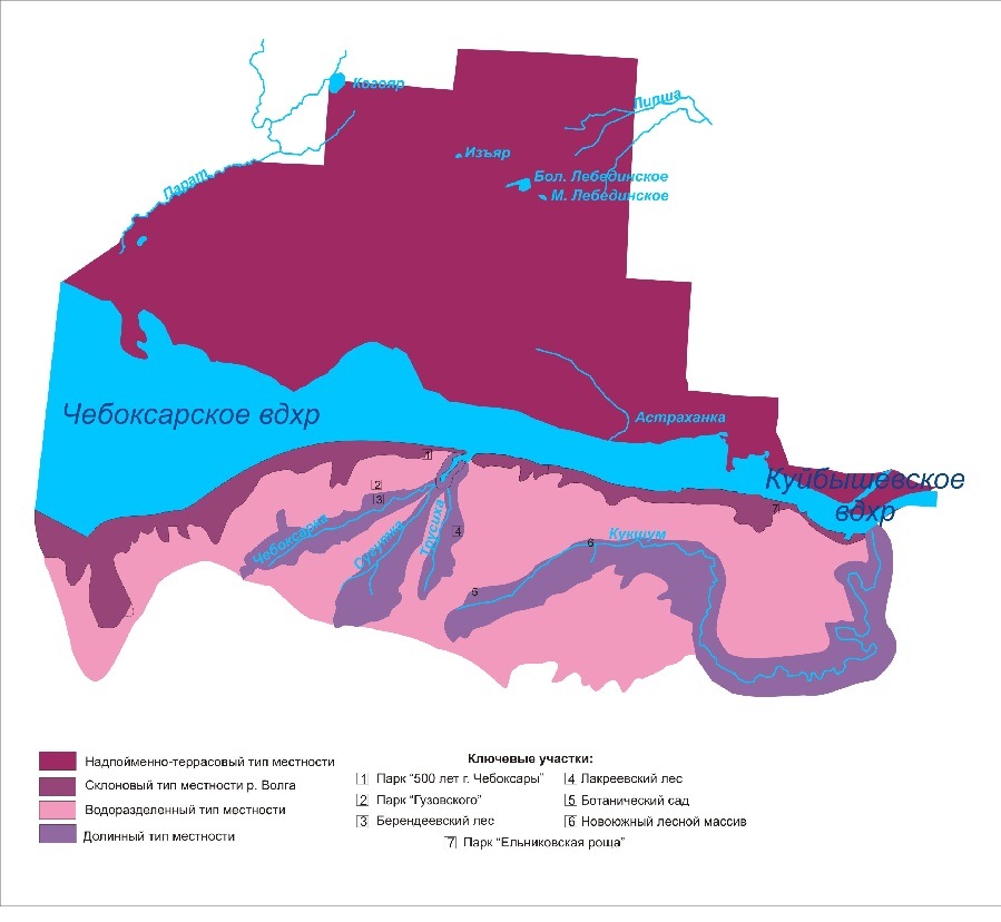
Fig. 1. Landscape layout on Cheboksary and Kuybyshev reservoir coast.
The territory of sanatorium-and-spa resort “Volzhanka” has been anthropogenically transformed, and is represented by slope area type with exposure to the east, with steep-slope gulley (20º), 60 m long, with washed-off soil.
The slope type of the relief is also presented in the Park Pobedy. The steepness of the slope is 20°, the length is 40 m with exposure to the north, on light-grey forest soil.
The slope type of the right bank area of the river Volga (Kuybyshev Reservoir) is presented by the key plot «Elnikovskaya Rosha». This plot is the natural landmark, which is represented by a sloping surface with rugged topography at the slope of northern exposition, steeply crumbling down to the valley of the Volga River, with absolute marks of the territory at 70-123 m, with difference of height at 50m and slope steepness from 9˚ to 24˚, and with near-Volga mountainous oak woods on light-grey forest soil. On the slope territory there are the following natural areas: slope surfaces with soddy-mesopodzol soil on loess loams with ferny oak woods and lime-hazel oak woods; slopes of hollows with exposure to the north with soddy-mesopodzol soil on loess loams with maple-lime-goutweed oak woods; slopes of hollows with exposure to the north-west with soddy-mesopodzol soil on loess loams with maple-lime-mercury oak woods; hollow bottoms with soddy-mesopodzol soil and ravine-hollow soil on alluvial-deluvial loess deposits with elm shrubs.
Water-dividing natural area “Rosha Guzovskogo” has the declining surface with the 4-7º incline, where the relief is of erosive character, and is represented by the closed type of landscape with zonal crown closure of lime-maple oak woods, soil covering is mostly light-grey and dark-grey soil of loamy mechanical character, formed on deluvial and alluvial Perm clays and loams.
Valley type of the river Cheboksarka area is anthropogenically transformed. This area is represented by steep slope (15-20º) with exposure to the north-east, of 15-20m length; partially slopes are occupied by low-height housing or by dacha-gardening units. The natural area “Cheboksar creek” is represented by the slope with the exposure to south-east and south, steepness of 15-25º, islets with maple-lime copse on light-grey forest soil.
At the inflow of the river Cheboksarka in Cheboksar Creek, the creek basin is covered by bank-protecting structures; around the perimeter of the creek there is the pedestrian zone, where the population of the city takes part in diverse recreational activities throughout a year. During summer season the water area is used for catamaran and boat sailing, fishing, and during winter season it is used for winter fishing, ice-skating.
The index plot «Berendejevski Les» is situated on the left slope of the river Cheboksarka with the inclination from the north to the south-east, and lays at the elevation points 120-160 m, elevation difference from north to south-east is 40 m. Continuous gradient of Berendejevski Les to south-east at the whole territory of the area is about 3º. The following surfaces by a gradient of the slope have been observed: low angle (1-3º); slight-slanting (3-5º) with maple-lime oak woods on light-grey forest soil; slanting (5-7º) with maple-lime oak woods on light-grey forest soil; steep (more than 7º) with maple-lime oak woods on light-grey forest soil. This area is used for skiing, sportive orienteering, laying of terrainkurs, race-walking.
Valley area type of the river Trusikha is as following: the relief of the territory is presented by steep slopes (15-25º) with lime-maple oak woods on light-grey forest soils.
There has been pointed out the index plot «Lakreejevsky forest», which is a natural landmark. The slope of broken ground with the exposure to the east is divided into the following natural areas: steep (15-25º) slope of the river Trusikha with lime-maple oak woods of light-grey forest soils; slanting (8-20º) slope of the river Trusikha with lime-maple oak woods of light-grey forest soils; low-angle (8-12º) slope of the river Trusikha with oak birch wood on of light-grey forest soils, plant communities are under strong antropogenic pressure; slight-slanting (8-12º) slope of the river Trusikha with maple oak woods on light-grey forest soil; slanting slope of spring valley with oak woods on slight-grey soil; slanting (8-12º) slope with grassland vegetation on alluvion. The slope with exposure to the west is built up with low-height housing or by dacha-gardening units/properties.
Valley type of the river Kukshum has been mostly modified by antropogenic activities. The relief is represented by slanting surface of more than 3º of slope inclination, with deciduous forest on grey forest soil. The index plots are situated here: “Botanicheski Sad”, Novojuzhny forest area and middle plot of the river Kukshum’s valley.
Novojuzhny forest area is represented by inclined slope with broken ground of near-Volga mountainous oak woods on light-grey forest soil. There has been noted the following surfaces with exposure to north-east by slope gradient: plain, with the angle of slope 0-1º formed by loess loam; slight-slanting, low-arched slopes with the angle of slope 1-3°, formed by loess loam with low watering, with maple-lime-goutweed oak woods; slopes of hollows, which are slight-slanting concave surfaces (dell) with angle of inclination of 1-3°, formed by loess loams, more watered; slight steep raised slopes, with angle of slanted surface of 3-5°, formed by loess loams; slight-slanting hollow slopes with exposure to south-west, with the angle of slanted surface of 5°-7°, formed by loess loams; slanted hollow slopes with the angle of slanted surface from 7° to 10°, formed by loess loams; penchant slopes of hollows with angle of slope 10-15° formed by loess loams with oakwoods with maple-lime underwood; bottoms of hollows with the angle of a slope no more than 2°, formed by alluvial-deluvial loess loams with flowing watering with elm shrubs. Slope inclination is from 5 о to 10-30 о and more. This index plot is characterized by advantageous conditions for skiing and sledging, and also for promenade and hiking.
The index plot «Botanicheski Sad» is represented by antropogenic landscape, and sloping (3º) surface with exposure to the south. Within the slope there have been observed anthropogenic natural areas: arboretum, preserved oakwood, rosary, shady garden, garden of riverian plants, the garden of continuous blossoming, exposition of plants of natural flora, Japanese garden, exposition of cultivated plants, plots of the natural forest and science research territories. This area is used for scientific and educational tourism.
The middle plot of the river Kukshum valley with hypsometric marks of slope shoulder of 138 m with exposure to south-west and north-east, with slope steepness of 10º and more, with washed-off soil, and here the farming lands of state owned farm «Kadykovsky» are located. This territory is used by the residents of the area for sledging and skiing in winter.
A terrace above flood-plain type of the area is located on the left bank of Cheboksary and its suburbs in the forest zone and belongs to the forest province of Nizmennoe Zavolgie. Forests of Zavolgie are mostly pinaceous. This is the part of the whole massif of Mariyski forest, which in its turn is the part of Nizhegorodskoe Zavolzhje. Rarely the plots of birch wood, aspen wood and lime wood are speckled among pinewood. In the west part an oak is met as subordinate species.
According to landscape zoning left bank area (Zavolzhje) belongs to the province of southern boreal forest of taiga zone. The Volga River separates it from the forest-steppe left bank area.
Left bank area (Zavolzhjye) of Ceboksary reservoir, city and suburbs are the part of taiga landscape zone, the south border of which goes along the Volga river. Here the balance of watering is positive. Terrain of Zavolzhje is lowland plain. True altitude does not exceed 150 m. Plainness of the territory and inconsiderable downcutting of rivers define low horizontal and vertical terrain roughness. Valleys of Zavolzhje rivers have aged and developed look. In Zavozhje eolian forms of terrain are widespread. Before afforestation of formed Volga terraces parabolic dunes of 10-15 m high and of 1-2 km long used to be formed here.
Horns of dunes are usually oriented on the east or north-east, pointing out the direction of prevailing winds. Dunes have been formed by eolian processing of Volga alluvia (Pic. 1). In topographic low of Zavolzhje marshes and lakes were formed.
According to the scheme of Middle Povolzhje physic-geographical zoning by F.N. Milkov and E.M. Rakovskaya (1953) the left bank suburban recreation zone of Cheboksary and its suburbs belongs to the forest zone, subzone of south taiga, province of lowland Zavolzhje.
According to A.V. Stupishin (1964) and E.G. Kolomyts (1995), Zavolzhje belongs within forest zone, subzone coniferous-deciduous (mixed) forest. In the atlas of agricultural sector of Chuvashia Republic, Zavolzhje is the forest zone, and the forest area of Zavolzhje lowland is Zavolzhje valley-terrace Polesye area.
High (third) terrace above flood plain of Volga (valley-outwashed) is gently undulating and flat, sometimes hummocky and pitted, greatly waterlogged, formed by sand and loams, with sod-podzol sandy and sandy-loam podzol soil in combination with marshy soil, with moss or myrtillus fir-pine forests in combination with moss, lichen or bog moss pine forests [1].
Low (first and second) terraces above flood plain of Volga are formed by sand with loam layers, with sod-podzol sandy and sandy loam soil in combination with marshy soil, with fir-pine forest, with from lichen bogs to sphagnum bog; in lowlands, on old felling plots, on abandoned peat mines deciduous forests with mostly birches and aspens prevail [5].
Natural areas here are flat-bottomed dry hollows, basins, drift hummocky sands, natural and homogenous/artificial pine forests and subors, with bayou lakes in near-bank area [2].
III. Conclusion
Analysis of differential landscape structure and recreation value of the district under study shows that this natural region has moderate variety of area types, but is defined by high sanitary-hygienic and aesthetic qualities, and therefore is foremost favourable for recreation of population of Cheboksary and its suburbs on Cheboksary and Kyubyshev reservoir coast.
1. Archikov, E.I. Location of the Chuvash Republic / E.I. Archikov. - Cheboksary: Chuvashia. Vol. Publishing House, 1998. - 94 p.
2. Atlas of agriculture Chuvash ASSR. - M .: Main Department of Geodesy and Cartography under the Council of Ministers of the USSR, 1974. - 68 p.
3. Gumenyuk, A.E. The use of intra-recreation area's. Cheboksary and Novocheboksarsk / A.E. Gumenyuk, I.V. Ilivanova // Ecological Bulletin of the Chuvash Republic. - Vol. 48, "Geo-ecological research in the Chuvash Republic" series. - Cheboksary: Chuvashia. Vol. Publishing House, 2008. Part 1. - Pp. 101-105.
4. Kuskov, A.S., Lysikova, O.V. Balneology and wellness tourism: Textbook. pos. - Rostov-na-Donu: "Phoenix", 2004. - 320 p.
5. Nikonorova, I.V. Geological and geographical features of the formation of the Chuvash plot Cheboksary and Kuibyshev reservoir. / I.V. Nikonorova, E.I. Archikov- Cheboksary: Chuvashia. state. University Press, 2000. - 104 p.
6. Sirotkina, M.M. Geographical analysis of natural factors and the assessment of the current gully erosion in the territory of the Chuvash Autonomous Republic / M.M. Sirotkina // Thesis Cand. geographer. Sciences. - Kazan. 1971.