


Russian Federation
BISAC NAT010000 Ecology
BISAC NAT045050 Ecosystems & Habitats / Coastal Regions & Shorelines
BISAC NAT025000 Ecosystems & Habitats / Oceans & Seas
BISAC NAT045030 Ecosystems & Habitats / Polar Regions
BISAC SCI081000 Earth Sciences / Hydrology
BISAC SCI092000 Global Warming & Climate Change
BISAC SCI020000 Life Sciences / Ecology
BISAC SCI039000 Life Sciences / Marine Biology
BISAC SOC053000 Regional Studies
BISAC TEC060000 Marine & Naval
The coasts of Baydaratskaya Bay are composed by loose frozen sediments. At Yamal Peninsula accumulative coasts are predominant at the site where pipeline crosses the coast, while thermoabrasional coast are prevail at the Ural coast crossing site. Coastal dynamics monitoring on both sites is conducted using field and remote methods starting from the end of 1980s. As a result of construction in the coastal zone the relief morphology was disturbed, both lithodynamics and thermal regime of the permafrost within the areas of several km around the sites where gas pipeline crosses coastline was changed. At Yamal coast massive removal of deposits from the beach and tideflat took place. The morphology of barrier beach, which previously was a natural wave energy dissipater, was disturbed. This promoted inland penetration of storm surges and permafrost degradation under the barrier beach. At Ural coast the topsoil was disrupted by construction trucks, which affected thermal regime of the upper part of permafrost and lead to active layer deepening. Thermoerosion and thermoabrasion processes have activated on coasts, especially at areas with icy sediments, ice wedges and massive ice beds. Construction of cofferdams resulted in overlapping of sediments transit on both coasts and caused sediment deficit on nearby nearshore zone areas. The result of technogenic disturbances was widespread coastal erosion activation, which catastrophic scale is facilitated by climate warming in the Arctic.
permafrost coasts, arctic coastal dynamics, monitoring, massive ground ice, technogenic impact, Kara Sea.
I. Introduction
Unlithified, ice-bonded sediments characterize 65% of the coast facing directly onto the Arctic Ocean [1]. Long-term (decadal) rates of coastal change are typically in the 1-2 m/year range [2].
Rates of shoreline change significantly vary along the Arctic Ocean coastline due to differences in geological (e.g. ice content, sediment type), geomorphological (e.g. exposure, elevation, slope) structure and hydrometeorological conditions (e.g. wave parameters, sea and air temperature). Most of the literature notes that storm events play a significant role in controlling the short term rate of coastal change [2-5]. The modern climatic changes, especially well expressed in the Arctic, contribute to the growth of the retreat rates of the coasts [1, 2, 4, 6]. The main factors influencing the speed of coastal destruction during warming are the increasing ice-free period and changes in the wave climate determined by this increase [3], while summer air temperatures as such, in most of the cases, show bad correlation with the rates of thermoabrasion [3, 4].
II. Research area
Baydaratskaya Bay is a shallow (up to 30 m depth) gulf in the south-western part of the Kara Sea (Fig.1). The bay is a former delta of the ancient Ob River. By the end of the Late Neopleistocene, sea level was lower than the modern bottom of the inlet; the bay as it is today formed as a result of Holocene transgression, when the eustatic sea level rise exceeded the relatively stable vertical uplift of the Earth’s crust in the region [7]. Sea level rise activated the destruction of coasts; periods of sea ice extent decrease correspond to ancient coastlines on the bottom of the bay [8]. Baydaratskaya Bay forms a separate lithodynamic area (Baydaratskiy area), which is one of the four lithoynamic areas in the south-western Kara Sea sector [9]. Along the modern coastline of the bay, abrasional (thermoabrasional, thermodenudational with height up to 40 m) and accumulative coasts alternate. Sediments outcropping in the coastal cliffs are perennially frozen deposits formed in the middle and late Neopleistocene and Holocene. They contain massive ground ice [10] and are often folded into complicated deformations [11].
History of investigations
Systematic investigations of the natural conditions along the gas pipeline “Yamal-Center” projected route started in 1988 with the works of the Arctic marine engineering-geologic expedition (AMIGE), Laboratory of geoecology of the North, Faculty of geography, Lomonosov Moscow State University (MSU) and other organizations. As a result of integrated studies of 1990-1996, conducted by IPO “Eco-system”, a monograph [12] characterizing different aspects of the natural conditions of the Baydaratskaya Bay coasts and water area was created. Coastal dynamics monitoring in the area of the coastal transition zone of the pipeline crossing was initiated by the scientists of the Laboratory of geoecology of the North, Faculty of geography, MSU, in 1988 [13].
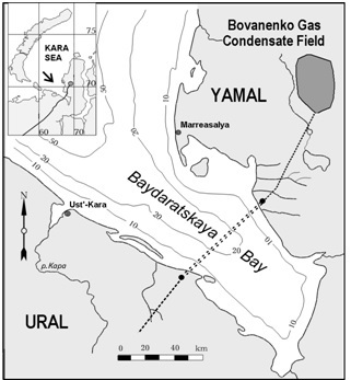
Fig.1. Underwater pipeline route across the Baydaratskaya Bay of the Kara Sea
Methods of coastal monitoring
On both coasts of the bay, in the planned area where the future pipelines would cross the coast, a network of benchmarks was established. In the sections of these benchmarks, repeated trigonometric leveling was conducted; profiles of the coastal zone from the top of the cliff on land to the outer margin of the tidal flat in the sea were drawn. Comparison of multitemporal profiles allowed to quantitatively characterize coastal dynamics for different types of coasts. Direct measurements were conducted in 1990, 1991, 1993, 1997, 2005, 2006, 2007, 2009, 2012 and 2013 within the Ural (29 profiles) and Yamal (17 profiles) coasts; lost monitoring benchmarks were set again, and new ones were established. Besides the direct measurements, coastal retreat rates were determined using the results of multitemporal aerospace imagery. The methods of referencing and processing of the imagery are given in details in [14].
III. yamal coast key site
Within the Yamal area, coastal dynamics monitoring was conducted at the 16-km long section from Mutniy Cape in the north to the mouth of Liyakha River in the south. The top of the plain come to the coast in the very north and south of the area, forming abrasion-thermodenudational cliffs of 8-12 m height and 4.5 km along the coast to the south of Mutniy Cape, and up to 22-28 m above sea level (a.s.l.) to the mouth of Yara-Yakha River. They are composed by relatively homogenuous strata, represented by sandy sediments with low ice content. In the middle part, where the system of pipelines is laid, the coast represents a Holocene barrier beach, the height of which was 1.6-2.1 m before the beginning of the construction, lowering landwards and followed in this direction by a low laida separating a shallow lagoon (Fig.2).
The coast of the area is protected from northerly and partly north-westerly winds by the Marresalskie Koshki Islands. The longshore sediment flux is directed from the mouth of Yara-Yakha River to the north up to Mutniy Cape, where it decreases, forming a wide tidal flat. In the Yara-Yakha River delta, the sediment flux migration is bilateral; most of the sediments accumulate from the northern side of the delta forming wide tidal flats as well.
During the period from 1988 to 2009, the average retreat rates of high thermoabrasional and thermodenudational coasts within this area were 0.4 m/year for the northern part (high coasts to the south of Mutniy Cape, 4.5 km along the coast), and 0.5 m/year for the southern part (3.5 km along the coast to the south of Yara-Yakha River mouth), respectively. In 2009-2012, after active construction started, the situation slightly changed. Retreat of the northern abrasional segment was enhanced within the 2 km adjacent to the coastal bar, where the rates of coastal destruction increased from 0.1-0.3 m/year in 1988-2009 to 1.3-5 m/year in 2009-2012. Abrasion also increased within 1 km to the south of Yara-Yakha River mouth; probably this was influenced by artificial deepening of the river mouth. Here, the retreat rates grew from 0.3-1.2 m/year in 1988-2009 to 2.3-7.9 m/year in 2009-2012. In 2012-2013, the coast became more stable on both of the areas due to the end of the main stage of construction and artificial sediment input along the barrier beach.
Before the beginning of the construction of the pipeline crossing in 2008, the coast within 3.5 km to the north of Yara-Yakha River mouth used to be accumulative. The cofferdam, erected above the two pipes, formed a re-entrant angle actively filled by sediments, from the southern side. As a result, by 2012, the tidal flat became 40 m wider to the south of the cofferdam and 50 m narrower to the north of it. The shortage of sediment flux which determined the activation of retreat of the abrasional cliffs to the north of the barrier beach is namely connected with the catchment of the longshore sediment flux by the cofferdam along with excavation of sand from the beach and tidal flat at the coastal section from the site of construction till the mouth of Yara-Yakha River (Fig.2, 3a). The barrier beach itself also experienced degradation in 2007-2012, above all, due to excavation of beach sediments and sediments from nearshore zone. In 2012, the maximal height of the coastal bar was 1.2 m (BS-77), while before the start of the construction it was 1.6-2.1 m. As a result of numerous heavy vehicles moving along the barrier beach a coastal cliff started to form in the dense peaty sediments of the barrier beach. In 2011-2012, the coast near the cofferdam was strengthened by concrete mats [15], which slowed up the retreat to some extent; however, already in 2012, these constructions started to be deformed (Fig.3b). No considerable changes in the topography of the barrier beach were seen in 2012-2013. In 2013, within separate areas to the north of the pipeline crossing, an increase of the height of the coastal bar by 0.2-0.6 m compared with 2012 was noticed. It is possible that in the conditions of thelowering technogenic impact and constant artificial sediment input on the beach, the barrier beach started to recover.
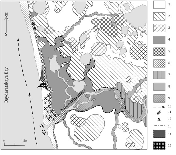
Fig.2. Scheme of Yamal coastal site central part. Geomorphological elements: 1 - surfaces and gradual slopes (< 5°) of 10-20 m a.s.l.; alas floors and gradual slopes: 2 – old, 3 – young; 4 – laida (marshy surface up to 4 m a.s.l.); 5 – beach, incl. barrier beach; 6 – tidal flat; River valleys: 7 – flood basin of large rivers, 8– valleys of small rivers and streams; 9 – river shoals. Coastal dynamics and technogenic impact features (2013 year): 10 – longshore sediment flux; 11 – the approximate location of cofferdam; 12 – sediment extraction sites; 13 – limit of storm waves landward penetration; 14 – zone of sediment deficit; 15 – zone of enhanced accumulation
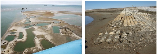
Fig.3. Technogenic impact on Yamal coastal site: a) site of sediment extraction from the beach and tidal flat to the north of Yara-Yacha River; b) deformation of concrete mats at lagoon coast
IV. Ural coast key site
In the area of Oyu-Yakha River mouth, monitoring of coastal dynamics was conducted for a segment between Torasovey and Levdiev islands. Here, surfaces of several types are cut by the coast. They all differ by height, cryolithological composition and coastal retreat rates.
The investigated area is characterized by relatively intense alongshore sediment flux. A unidirectional wave energy flux, beginning at the southern end of Torasovey Island, gradually decreases towards the south-west. The coast is open to wind-wave and ice impact from the Kara Sea.
During the years of field measurements and terrestrial observations, the most representative data without gaps have been received for 11 profiles, situated between the mouths of Oyu-Yakha and Niudiako-Tamyakha rivers (6 km of the coast). From the west to the east, 4 segments are selected.
1) Abrasional-accumulative coastal segment (cliffs 5-8 m a.s.l.), partly protected from the wave impact by a barrier beach, 0.3 km along the coast. Retreat rate before construction (1988-2009) here were 0.3 m/year and increased in 2009-2012 till 1 m/year, probably due to reasons, not connected with construction.
2) High thermoabrasional coasts composed by thick sandy strata with layers of loam and gravel containing thick (up to 3.5 m) massive ice beds [10, 16]; in the eastern part of the area with thick peatlands and ice wedges, with which gully thermoerosion in associated. Here, within 1.8 km along the coast, a surface is complicated by numerous thermokarst depressions and lowered by them to 10-18 m a.s.l., comes out to the shore. Average retreat rate before construction (1988-2009) were 1.4 m/year (up to 2 m/year at profiles with massive ice beds exposures) and haven’t changed in 2009-2012.
Within 2 km to the west of Oyu-Yakha mouth, similar sandy strata outcrops in the costal cliff, while the ledge itself is higher (29 m), and the layers of tabular ground ice are thicker (6 m). There were no direct observations after 2007, while during 1988-2007 the coastal retreat rates were similar to those at the segment 2 (up to 2 m/year).
Coastal bluff retreat for the period 1964-2012 were determined for part of segments 2 and 3 based on multitemporal aerospace imagery comparison (Fig.4, [18]).
3) Laida thermoabrasional coast 0.5-2 m high (1.5 km along the coastline) are composed by silty sediments with high ice content due to wedge ice. Low-lying coasts are the most sensitive to changes in parameters affecting coastal dynamics since waves during storm surges penetrate far inland, simultaneously eroding the coast and providing a warming effect to the frozen sediments. The material formed by the erosion of the coast is quickly removed by waves due to its small volume. In 1988-2009 laida retreated with rate about 2.6 m/year, and after the construction beginning – 6 m/year in 2009-2012.
4) At the 1.5 km long fourth segment, separated from the east by Niudiako-Tamyakha River and including the pipeline crossing, a thermoabrasional-thermodenudational cliff is formed in a residual part of a surface of 5-7 m height (up to 8 m near the cofferdams erected above the pipelines, including sandy filling). Here, sandy loams with a system of polygonal ice wedges, along with loamy and silty deposits in the lower part of the cliff, often lying below sea level, are destructed by abrasion [10, 16, 17]. During 2005-2009 retreat rate were about 2.9 m/year, in 2009-2012 it increased till 4.3 m/year. But in exact sites thermoabrasion rates became higher after pipeline crossing construction has started.
Construction of two cofferdams at a distance of 70 m apart lead to lack of sediments between them and high retreat rates of coastal bluff; which were even higher due to linear erosion developing on wedge ice. In 2012 the coast between the cofferdams and 150 m to the east of the eastern cofferdam was protected by artificial boulder filling. Further to the east, the filling was not made, and the coast was affected by active abrasion. However, compared to 2007-2012, changes in the topography of the coastal zone of the Ural area in 2012-2013 were not considerable.
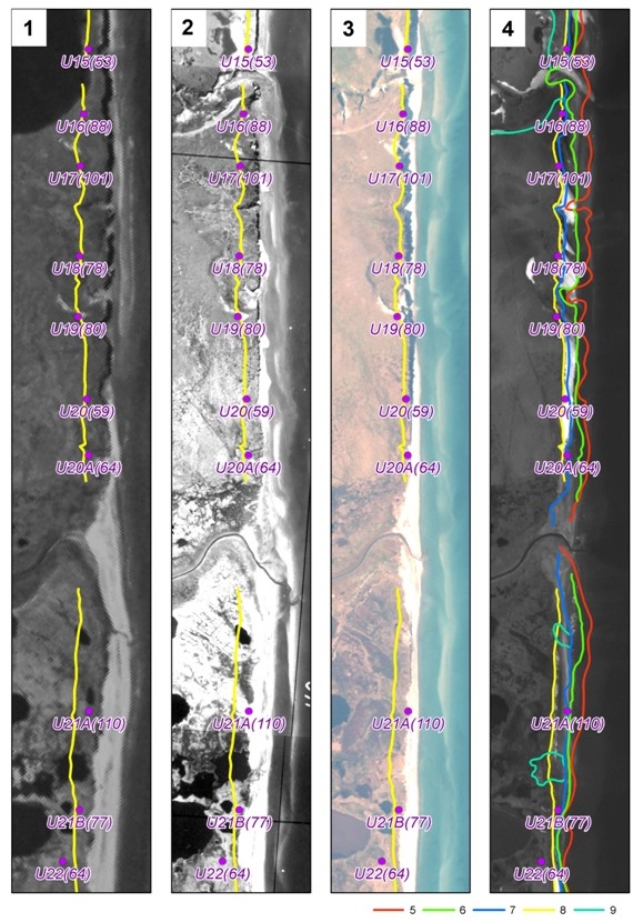
Fig. 4. Dynamcis of thermoabrasinal coastal segment (Ural Coast, Baydaratskaya Bay, Kara Sea [18]): 1 – Corona image (1964), 2 – aerial photo (1988), 3 – QuickBird image (2005), 4 – Formosat2 image (2012) with coastal bluff position in: 5 – 1964, 6 – 1988, 7 – 2005, 8 – 2012; 9 – limits of the modern khasyreys at the place of drained lakes. U21A(110) – number of benchmark of the coastal dynamics monitoring network (value of retreat of the coastal bluff from 1964 to 2012, m, given in brackets)
In 2013 the greatest changes were observed near the eastern cofferdam where heights of the surface near the seaward part of the cofferdam increased by more than 1 m from 2012 to 2013, as a result of which, a tidal flat of about 40 m width formed here. This is connected with high volume of filling made in the period between the monitoring of 2012 and 2013 to prevent the destruction of the cofferdam.
To the east of Niudiako-Tamyakha River, within 3 km up to Levdiev Island, low laida coast with heights up to 2.5 meters is observed. On part of the profiles in this section, observations started in 2005 only; however, the acquired data allow to characterize the dynamics of this area. As on segment 3, the direct measurements confirmed significant variations of coastal retreat rates in time due to low stability of such coasts, and in space due to local technogenic impact (heavy vehicles, see below).
Temporal variability of coastal dynamics
Generally, three typical stages of coastal dynamics can be selected: two periods of abrasion activation (1988-1996 and 2005-2012) and a period of abrasion decrease (1997-2005). These periods have been seen also at Yamal coastal site but were less pronounced there due to lower retreat rates and less diverse sediments types composing coastal bluffs. In 1997-2005, a negative peak is shown for all the profiles at Ural coast. It coincides with a minimum in wind-wave energy due to little occurrence of storm events, in spite of increase in the ice-free period. After 2005 the increase of the ice-free period continued, which resulted in periods of storms and winds falling into the ice-free period. As a result, most of the profiles show a 1.5–2 times increase of retreat rates compared to the average.
In 2009-2012, after the construction of the underwater pipeline crossing, retreat rates became even higher. The biggest retreat values were from 6 to 18 m/year, which is a record for the observations within the Ural coast. Dramatic destruction was observed even within the accumulative laida coast near Levdiev Island. The coast retreated by 55 m in 2009-2013, which corresponds to an average rate of 18 m/year. The reason of such dramatic change lies in the road which came through the beach and laida surface at this segment, with several heavy vehicles a day passing on the beach and littoral. In 2012-2013, this segment didn’t retreat more than 3 m.
V. Conclusions
In general, the Yamal coast of the Baydaratskaya Bay is characterized by lower retreat rates than the Ural coast. The reason lies in the difference in the ice content and composition of permafrost within the two sections. For the Ural coast, high ice content of permafrost is typical. Presence of ice wedges and massive ice beds which results in quicker coastal retreat. Another important feature is that the Ural coast is more influenced by the temperature factor, because of the high ground ice content. On the contrary, the Yamal coast is more dependent on the wave energy amounts. The technogenic impact played a dramatic role for the Ural coast, as well as for Yamal, however, for the Ural coast the consequences were bigger (with retreat rates of up to 18 m/year). This may be also connected with higher ground ice content, especially in the sediments of low laida, which are the most affected by the waves, and which were turned into roads destroying the natural cover of the accumulative forms. Nevertheless, for both coasts there was a trend of decrease in the coastal destruction in 2013, which testifies that after the period of the highest anthropogenic impact, the destruction is starting to slow down and doesn’t turn into a process which cannot be turned back.
In this way, we can conclude that coastal dynamics within the south-western Kara Sea depend on many factors. Quaternary sediments composing the thermoabrasional cliffs, their grain size, mechanical properties, and especially ice content are of great importance. These factors influence considerably lateral distribution of average retreat rates. Changes in temporal distribution of the coasts’ retreat velocities are caused in fluctuations of hydrometeorological conditions in the case of undisturbed ecosystems; however, coastal destruction can be dramatically enhanced due to technogenic impact, as it has been shown for the areas of underwater pipeline crossing on both the Ural and Yamal coast of the Baydaratskaya Bay. In this case, low coasts and coasts composed by sediments with high ice content, are also especially vulnerable.
VI. Acknowledgments
The work has been supported by Russian Foundation for Basic Research, projects 16-35-60099 mol_a_dk, 14-05-00408a, 16-45-890076 r_a and 16-35-00453 mol_a.
1. H. Lantuit, P.P. Overduin, N. Couture, F. Aré, D. Atkinson, J. Brown, G. Cherkashov, D. Drozdov, D.L. Forbes, A. Graves-Gaylord, M. Grigoriev, H.-W. Hubberten, J. Jordan, T. Jorgenson, R.S. Ødegård, S. Ogorodov, W. Pollard, V. Rachold, S. Sedenko, S. Solomon, F. Steenhuisen, I. Streletskaya, A. Vasiliev and S. Wetterich,. “The Arctic Coastal Dynamics database: a new classification scheme and statistics on Arctic permafrost coastlines”, Estuaries and Coasts, 2012, 35:383-400.
2. D.L. Forbes (editor), State of the Arctic Coast 2010 - Scientific Review and Outlook. International Arctic Science Committee, Land-Ocean Interactions in the Coastal Zone, Arctic Monitoring and Assessment Programme, International Permafrost Association. Helmholtz-Zentrum, Geesthacht, Germany, 2011, 178 p. http://arcticcoasts.org
3. F.E. Are, Coastal erosion of the arctic lowlands. Editor-in-chief V.P. Mel¬nikov. Novosibirsk: Academic publishing house “GEO”, 2012, 291 p. (in Russian).
4. S.A. Ogorodov, The role of sea ice in coastal dynamics. Moscow: MSU Publishing, 2011, 173 p. (in Russian).
5. A.A. Vasiliev, I.D. Streletskaya, G.A. Cherkashev and B.G. Vanshtein, “Coastal dynamics of the Kara Sea”, Earth Cryosphere, vol. X, 2, 2006, pp.56-67 (in Russian).
6. E.I. Pizhankova, “Modern climate change at high latitudes and their influence on the coastal dynamics of the Dmitry Laptev Strait area”, Earth Cryosphere, vol. XX, 1, 2016, pp.51-64 (in Russian).
7. A.V. Baranskaya, I.S. Yozhikov, Yu.I. Kuchanov, H.A. Arslanov, A.Yu. Petrov, F.E. Maksomov, “Quaternary sediments, paleogeography and vertical movements of the earth’s crust in the north of Yamal and Gydan peninsula during late Pleistocene-Holocene”, Moscow University Vestnik. Series 5. Geography, 2016, in press (in Russian).
8. V.Yu. Biryukov, V.A. Sovershaev, “Bottom relief of the south-western part of the Kara Sea and its Holocene history”, in Geology and geomorphology of continental shelf and slope. Moscow: Science, 1985, pp. 89-95 (in Russian).
9. B.A. Popov, V.A. Sovershaev, V.N. Novikov, V.Yu. Biryukov, A.M. Kamalov, E.V. Fedorova, “Coastal zone of the seas of Pechora-Kara region”, in Investigations of sustainability of northern geosystems. Moscow: MSU publishing, 1988, pp. 176-190 (in Russian).
10. N.G. Belova, Massive ice beds of the south-western coast of the Kara Sea. Moscow: MAKS Press, 2014, 180 p. (in Russian).
11. A.V. Baranskaya, D.Yu. Bolshiyanov, Yu.I. Kuchanov, V.M. Tomashunas, “New data on dislocations in the Quarternary deposits of the Yamal and Gydan peninsula and the latest tectonic movements associated with them by the results of the “Yamal-Arctic-2012” expedition”, Problemy Arktiki i Antarktiki, 2013, 4(98), pp. 91-102 (in Russian).
12. Baydaratskaya Bay environmental conditions. The basic results of studies for the pipeline “Yamal-Center” underwater crossing design. Moscow: GEOS, 1997, 432 p. (in Russian).
13. A.M. Kamalov, S.A. Ogorodov, V.Yu. Birukov, G.D. Sovershaeva, A.S. Tsvetsinsky, V.V. Arkhipov, N.G. Belova, A.I. Noskov and V.I. Solomatin, “Coastal and seabed morpholithodynamics of the Baydaratskaya Bay at the route of gas pipeline crossing”, Earth Cryosphere, vol. X, 3, 2006, pp.3-14 (in Russian).
14. S.A. Ogorodov, N.G. Belova, D.E. Kuznetsov, A.I. Noskov, “Using multi-temporal aerospace imagery for coastal dynamics investigations at Kara Sea”, Earth from Space - the Most Effective Solutions, 2011, 10, pp. 66-70 (in Russian).
15. A.A. Ermolov, “Morpholithodynamic research as a part of engineering surveys for construction”, Engineering Surveys, 2014, 9-10, pp. 86-89 (in Russian).
16. N.G. Belova, “Buried and Massive Ground Ice on the West Coast of Baida¬ratskaya Bay in the Kara Sea”, Ice and Snow, 2(130), 2015, pp. 93-102 (in Russian).
17. D.M. Aleksyutina, R.G. Motenko, “Thermal properties and phase composi¬tion of the water in frozen soils of the Baydaratskaya Bay Ural coast”, Engineering Geology, 2013, 3, pp. 36-43 (in Russian).
18. A. Vergun, A. Baranskaya, N. Belova, A. Kamalov, O. Kokin, D. Kuznetsov, N. Shabanova, and S. Ogorodov, “Coastal dynamics monitoring at the Barents and Kara seas”, Society of Petroleum Engineers - SPE Arctic and Extreme Environments Conference and Exhibition, AEE 2013, Moscow, vol. 3, 2013, pp. 1972-1990