


BISAC NAT010000 Ecology
BISAC NAT045050 Ecosystems & Habitats / Coastal Regions & Shorelines
BISAC NAT025000 Ecosystems & Habitats / Oceans & Seas
BISAC NAT045030 Ecosystems & Habitats / Polar Regions
BISAC SCI081000 Earth Sciences / Hydrology
BISAC SCI092000 Global Warming & Climate Change
BISAC SCI020000 Life Sciences / Ecology
BISAC SCI039000 Life Sciences / Marine Biology
BISAC SOC053000 Regional Studies
BISAC TEC060000 Marine & Naval
The dynamics of thermoabrasion coasts on loose sediments under permafrost conditions are highly variable due to several factors: length of the dynamic period of the year, mechanic composition of the frozen ground and its ice content, hydrometeorological conditions, and human impact. Multiannual monitoring of the coastal zone was carried out by Lab. Geoecology of the North (Moscow State University) at the 22 km long Kharasavey deposit site, Western Coast of Yamal Peninsula (Kara Sea). The methods include direct measurements and observations (repeated topographic survey of shore transects from 1981 to 2012) along with remote sensing data analysis (images from 1964 to 2011). This allowed producing detailed characteristics of coastal dynamics. At the site, thermoabrasion coasts occupy the most part, and accumulative coasts are present in the north. Data on natural relief forming factors and ground composition are included in the detailed geomorphologic map of the site. Shore retreat rate shows correlation to amounts of wind-wave energy and to specific wind directions. Human impact on the coast includes dredging at the port channel, mining of sand, driving motor vehicles, and deposition of construction debris. Relations between shore retreat rate and aforementioned factors were studied, including dependencies on ice content, and shore segmentation was carried out. This allows for coastal dynamics forecasts in the region.
The dynamics of thermoabrasion coasts on loose sediments under permafrost conditions are highly variable due to several factors: length of the dynamic period of the year, mechanic composition of the frozen ground and its ice content, hydrometeorological conditions, and human impact. Multiannual monitoring of the coastal zone was carried out by Lab. Geoecology of the North (Moscow State University) at the 22 km long Kharasavey deposit site, Western Coast of Yamal Peninsula (Kara Sea). The methods include direct measurements and observations (repeated topographic survey of shore transects from 1981 to 2012) along with remote sensing data analysis (images from 1964 to 2011). This allowed producing detailed characteristics of coastal dynamics. At the site, thermoabrasion coasts occupy the most part, and accumulative coasts are present in the north. Data on natural relief forming factors and ground composition are included in the detailed geomorphologic map of the site. Shore retreat rate shows correlation to amounts of wind-wave energy and to specific wind directions. Human impact on the coast includes dredging at the port channel, mining of sand, driving motor vehicles, and deposition of construction debris. Relations between shore retreat rate and aforementioned factors were studied, including dependencies on ice content, and shore segmentation was carried out. This allows for coastal dynamics forecasts in the region.
I. Introduction
The development of Russian sea coasts and continental shelf for natural gas mining requires construction of sea ports, approach channels, artificial islands, drilling platforms, terminals, ground-surface and underwater pipelines. Knowledge of natural processes, particularly coastal dynamics is necessary for geotechnical and geoecological safety of the facilities’ construction and operation. This is especially important in the Arctic where natural conditions play a crucial role in the coasts and shelf exploitation. Natural morpholithodynamic processes such as coastal erosion, thermoabrasion, thermodenudation, deflation, linear and thermal erosion, ice gouging, can lead to significant loss of property or extinguish the efficiency of the carbohydrates’ extraction and transporting [1] [2].
The particularity of the Kara Sea, as of most of the Arctic seas, is that the development of the coastal zone is determined by a contact with perennially frozen ground – the cryolithozone. The morpholithodynamic characteristics of this zone are one of the main factors determining the choice of means of petroleum transport. Despite the long ice-covered season (9 months in a year), coastal processes are very active during the remaining warm period [3]. For instance, at the Kharasavey section of the Kara Sea Coast (Fig. 1) more than half of the coastal line is influenced by coastal erosion processes, moreover, in some spots the velocity of coastal destruction reaches 1-3 m per year [4]. Taking into consideration the possible human impact following the exploration of new territories and the global climate warming predicted for the XXI century, coastal destruction velocities may significantly increase. In case of construction in the actively retreating parts of the coasts, a direct risk of its damage as a result of possible exposure and mechanical deformations appears. Protective measures often turn out to be ineffective as for the actively denudating coasts, not only bluff retreat, but also direct beach and underwater slope erosion occurs. Moreover, at specific conditions, exposed parts of structures can become directly affected by sea ice impact. Fast ice pushed onshore can result in destruction of coastal infrastructure.
Therefore, within the coastal zone geotechnical safety and geoecological safety of the surrounding area can be in a considerable way provided by the competent choice of the most dynamically stable section of the coast for construction [5].Figure labels should be legible, about 10-point type.
II. Site description
The coastal area of Yamal between capes Kharasavey and Burunniy consists of accumulative plain with heights from 0 to 25 m a.s.l. (Fig. 1) The deposits are composed of lenses of silty sand layers of late Pleistocene and Holocene, with thickness of 15 - 30 m in total. The following suites are recognized [4]: (1) Karginsky to Sartan deposits of the marine terrace 10-20 m a.s.l. (mQIII3-4); (2) Sartan to Early Holocene alluvial-marine deposits of the terrace 6-12 m. a.s.l. (amQIII4–QIV1); (3) Holocene lacustrine and boggy deposits at the flat surfaces of the terrace levels and within khasyreys (bottoms of drained thermokarst lake depressions) (lbQIV); (4) Middle to Late Holocene coastal marine deposits of the modern accumulative marine terrace (laida) 2-5 m a.s.l. (mQIV3-4) together with alluvial-marine deposits of the terrace 2-6 m a.s.l. found along river estuaries (amQIV3-4), beach and tidal flat (mQIV4), and barrier beach (emQIV4) deposits; (5) Holocene alluvial deposits within river valleys (aQIV).
The aforementioned strata are composed mainly of permafrost sediments that have continuous coverage in the area. Within marine terrace area the foot of the 0°С isotherm lies at 250-300m depths. Permafrost sediments below annual variation level have temperatures from -7 - -8°С within sandy marine terraces to -3 - -6°С within shore area. The active layer thickness varies from 0.3-0.5 m at swamped peat and silt surfaces to 1.1-1.8 m at bare sand surfaces.
The higher marine terrace (10-20 m a.s.l.) consists of fine silty sands at the top, underlain by dark grey frozen clays and silty clays. Due to aquiclude at the top of the clay layer (at depths of 0.4-0.6 m) block landslides on gentle slopes (2-10°) are common in the area. The lower marine terrace (6-12 m a.s.l.) consists of fine sandy loam with fine silty sands, silts, and loams at the surface. In the latter case, mud boil patterns are often observed. In case of sandy sediments at the surface, deflation processes occur. Deflation patches are usually below several meters in size, rarely reaching 12 m
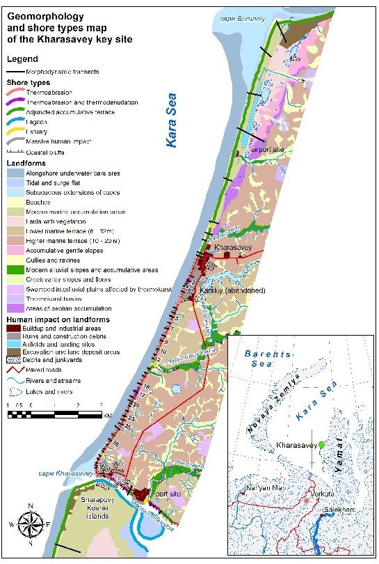
Fig.1. Key site location and geomorphologic map
Massive ice and ice wedge polygons are both present in the area, as well as other cryogenic textures of various morphology [6]. Among cryogenic landforms, most often are palsas and frost heave mounds up to 0.5 m in height and 5-8 m in diameter. Within riverbeds of small rivers and creeks, as well as small lakes, repeated frost heave occurs, which may lead to formation of larger mounds (height 2-3 m, diameter 15-35 m at the base).
Erosional dissection is present mainly as thermoerosion forming along ice wedges, which is main origin of gullies in the area. Thermokarst is less developed. There is no large and distinct thermokarst depressions, and the present ones are reworked by erosion. The bottoms of the khasyreys are boggy and consist of peat (often above loams).
Main thermoerosion forms are gullies and ravines which form furcated network and usually are found on well-drained surfaces composed of sandy sediments. Ravine bottoms are usually flat, boggy, several meters in width and consist mainly of peaty loams, silts, and silty sands. Along abrupt slopes such as coastal bluffs thermoerosion gullies are formed. They feature low vegetation cover on their slopes and absence of flat bottom surface. Erosion scours form mainly on surfaces undergone human impact, or at actively retreating shore sections. They are most developed at the coast around Kharasavey and Karsky settlements, where natural vegetation cover is mostly destroyed, and landfill is done with local fine sands that can easily be washed away.
River valleys of Nyavotalova-Yakha and Hardyakha usually feature well developed floodplains adjunct to flat or gently sloped terrace levels found locally as single fragments. Terrace level heights are usually not constant, their surfaces are reworked by slope and cryogenic processes. Upper parts of valley slopes are generally scalloped with numerous active and conserved landslide cirques.
Considerable human impact on the area takes place starting from 1980s, and a number of anthropogenic landforms is present, concentrating mainly around settlements of Kharasavey and Karsky, as well as the port site (which also hosts large number of abandoned military structures and the former Kharasavey polar station) and the former airstrip. The landforms are mainly flattened sites, landfill, rubbish and construction waste deposits, and areas of modern buildup, as well as ruins of former structures of residential, industrial, and infrastructural use. Also anthropogenic pressure has considerably hastened natural geomorphic processes such as thermoabrasion, linear erosion, and thermokarst in areas of human impact.
According to the morphogenetic classification of the coasts [7], several types of coasts were distinguished (Fig. 1). Each type is characterized by various distinct geomorphic processes.
Accumulative coasts are found mostly between cape Burunniy and Kharasavey settlement, with the most fully developed shape around cape Burunniy. The beach consisting of well sorted fine to medium sands gradually rises to the height of the bare laida surface. Vegetation cover starts around 0.5-0.7 km from the shoreline. Around 1.5 km from the shoreline the gentle slope of the marine terrace starts. To the south of cape Burunniy, modern accumulative terrace (consisting of the broad beach and laida) gradually narrows to 30-50 m, having chains of residual lagoon lakes behind it. These lakes currently lie beyond sea water influence during extreme storm surges.
Accumulative lagoon coasts are found at Sharapovy Koshki islands which effectively represent a coastal barrier. These coasts consist mainly of silty fine sands. The islands' height rarely exceeds 2 m, making this coast susceptible to storm surges which may flood most its part.
Accumulative estuary coasts are situated at mouths of rivers such as Nyavotalova-Yakha and Hardyakha. They are characterized with wider beaches that protect nearby coastal bluffs from erosion, and underwater fans of alluvial sediments.
Erosion coasts dominating between Kharasavey settlement and cape Kharasavey are divided between thermoabrasion and abrasion-thermodenudation coasts. They consist mainly of fine silty sands, along with loams and clays. Grain size in coastal bluff sediments is usually much thinner than at the adjacent beach.
Thermoabrasion coasts are situated mostly between the settlement and cape Kharasavey, and also at the northern shore of Sharapov Shar strait. The principal geomorphic process on these shores is thermoabrasion, while slope processes (landslides, thaw slumps, taluses) also contribute to the destruction of bluffs. Slope processes developing mostly in the upper (thawed) part of the bluff create graded profile with the flat part forming at the base of the active layer. The lower flat step often forms at the top of debris cones on overlying the beach. In this case, the lower part of the bluff where frozen ground is closer to the surface is protected by the debris cones, and the shore retreat rate decreases. All erosion coasts in the area contain permafrost, therefore its characteristics (geological composition, ice content, grain size) greatly influence the retreat rate. Sands (both frozen and thawed) are least resistant to thermoabrasion, heavy loams and clays are more resistant.
Abrasion-thermodenudation coasts are found mostly at the northern shore of Sharapov Shar strait, and as small sections around Karsky settlement and to the south from Nyavotalova-Yakha river mouth. Comparing to thermoabrasion coasts they have more gentle bluff (below 40°), usually covered with vegetation. Thermodenudation forming this type of coasts consists of the complex of geomorphic processes (deluvial erosion, solifluction, thaw slumps and landslides). Thermodenudation is especially active at shores composed of loams forming landslides, with detached blocks as an initial stage. In general, abrasion-thermodenudation coasts are more stable than thermoabrasion coasts.
Coasts bearing massive human impact are found locally at parts of the northern shore of Sharapov Shar strait. At the port site the metal quayside 3-5 m tall is found. Around cape Kharasavey the coast is highly affected by human activity, bearing numerous debris piles, ruins of buildings, ships, temporary quays, etc. Since this often leads to placing of large blocks of construction materials at the shore, the retreat rate there is slower than at the adjacent shore sections. Human impact is also occasionally found at other types of shores as sand mining for construction purposes, traffic tracks, and sewage discharge. In this case, shore retreat is hastened.
Coastal zone in the Kharasavey area is highly dynamic, depending on wave activity, tidal and surge events, alongshore currents. Material arriving in the coastal zone in results of the erosion is then transported and redeposited at the underwater slope, often close to the shore. Subaqueous deposits of the shallow part of the slope consist of light-gray well washed and sorted fine quartz sands. Granulometric composition of surface coastal sediments is almost constant along the shore, as well as over the slope. Small variations present in admixtures of other fractions in the dominating fine sand. Slight decrease in average grain size occurs with depth due to increase in fine sand (from 3–6% to 4–8%) and silt (from 0,1–1,4% to 0,8–2,3%) fraction content, and to absence of coarser fractions at depths below 3.5 m. Sediments have very good sorting with 89-97% in the leading fraction. Maximal degree of sediment sorting is observed at 1.5 m depth.
III. Methods
To determine the speed of coastal retreat and peculiarities of the shore zone deformations, 58 morphodynamic transects were established for coastal dynamics monitoring. The benchmarks of the transects were attributed to the Baltic system of heights of 1977. Coastal dynamics monitoring from constant benchmarks is executed by direct measurements and by trigonometric leveling [8]. For sea bottom deformations measurements, echo sounding is executed on the underwater continuations of the morphodynamic transects. However, direct instrumental monitoring of coastal dynamics in remote Arctic conditions is particularly expensive due to the difficulty of access to the object of investigations. Also, it doesn’t provide the complete picture of long-term trends of coastal development for extended areas. The latter is extremely important for forecasting of coastal dynamics and underwater slope deformations on the long term of 30-50 years (estimated facilities lifetime). In this case, the analysis of multitemporal remote sensing data becomes indispensable.
A substantial method of receiving an overview of multiannual coastal dynamics is studying multi-temporal cosmic images. Among archive materials of cosmic images, the data from the Corona system for the period of 1961-1970 is of greatest interest. Their major advantages are accessibility, the fact that almost all the Earth surface is covered and high resolution (4-7 m). The Corona datasets enable not only to assess the general shore zone dynamics from 1962 until now, but also to reveal the 1960s coastal dynamics particularities. Modern extra-high definition materials from Ikonos and QuickBird satellites are also available for a considerable part of the explored territory. Also, medium definition materials from Landsat 3-7 satellites are available with maximum resolution up to 15 m. The advantage of Landsat imagery is the wide choice of free available materials for a considerable period of time (from 1999 up to the present moment). These scenes are suitable for preliminarily analysis of the lithodynamic setting of the region.
One of the most important information source regarding Russian Arctic coastal dynamics are the state topographic and navigational maps. As a rule, these materials are used as a cartographic basis for the following analysis. The materials processing includes georeferencing in the WGS-84 system and metadata assignment; in most of the cases for the commodity of further analysis the received data is vectorised.
The preparation of the obtained aerial and satellite imagery is the most important stage in the Arctic coastal dynamics investigations. Special attention should be paid to the spatial reference of the data. Ikonos and QuickBird images are provided with the reference files created automatically. This kind of referencing is precise enough for coastal areas because the error between the heights on the terrain and the geoid level are negligible. Our own investigations show that the reference error in the areas of interest doesn’t exceed 5 m that is sufficient for coastal dynamics analysis.
Corona satellite images may only be obtained as a simple raster file and therefore need georeferencing. Ikonos and QuickBird images, as well as topographic maps or field GPS-points, can be used as benchmark data. Because of their considerable coverage, Corona images have trapeze-like deformations in their peripheral part. For their referencing, special methods allowing the curvature of initial data (polynomial transformations, “rubber sheet” method) should be used. The main problem regarding referencing of aerial and satellite imagery is the lack of stable points which is caused by little anthropogenic presence in the explored region. Consequently, hydrographic objects are often used in georeferencing (rivers, lakes, ravines and depressions). Their position is often unstable, which increases the error probability. To avoid this, vectorisation of the hydrographic system contours is executed with the help of a high resolution image which is already referenced. For regions with developed erosion systems, good results can be obtained by setting the control points on the confluence of ravines in their upper parts, on river effluences from lakes, on axis lines of short channels connecting neighboring lakes, since the horizontal position of these points remains stable for a long time. The output resolution of the image should be chosen taking into consideration the maximum preservation of the initial information.
After the referencing of all the multitemporal images available for the territory, the interpretation stage starts. One of the most spread and well decipherable signs for thermoabrasion and accumulative coasts is the cliff line and the border of the continuous vegetation cover. Based on the satellite imagery, the cliff edge (for abrasion sections) and the continuous vegetation limit (for accumulative sections) are digitized. By superimposing the limits of landforms it is possible to assess the deformations of these forms. With use of satellite images we can also determine the location and evolution of the underwater bars which are quasi-ephemeral landforms and can completely change their position during several years. A geomorphologic process which is easy enough to decipher in the cryolithozone is the forming of khasyreys. Their formation is often closely connected to the process of thermal abrasion, which may eventually destroy the bank of the lake, causing its drainage.
IV. Results and discussion
Repeated observations of coast development at the Kharasavey site started in 1981. For shore sections with the most full history of observations the analysis of erosion within 31-year cycle (from 1981 to 2012) was carried out. The results are presented at Fig. 2 and Fig. 3.
Coastal retreat rates vary greatly both for same shore sections in different years, and for different sections within one time period. Periods of stability or low retreat rate are changed with periods of abrupt activation of erosion, and active destruction of bluff at one section may be accompanied with stability at the other section [9]. It is probable that the retreat rate at every single shore section is controlled by local geomorphologic conditions and intensity of human impact rather than climatic situation which is same for the whole area. The geomorphologic conditions include the susceptibility to erosion of sediments currently exposed at the bluff, stage of cyclic processes such as block detachment at ice wedge polygon ground, etc.
For different shore types, various average annual retreat rates are characteristic. Thermoabrasion coasts are most actively retreating. Due to immediate wave transport of sediments from the beach bluff destruction is hastened not only by erosion itself (which is considerable only during the strongest storms), but also due to active slope transport caused mainly by thermodenudation processes (landslides, thaw slumps, solifluction, linear erosion and thermoerosion). Since the material is constantly removed from the accumulation zone by the action of waves, the dynamic system of slopes is being kept out of equilibrium state and the bluff destruction speeds up. In case of abrasion-thermodenudation coast such type of activation is less pronounced and the bluff does not undergo direct wave action, therefore the destruction of such bluffs goes much slower.
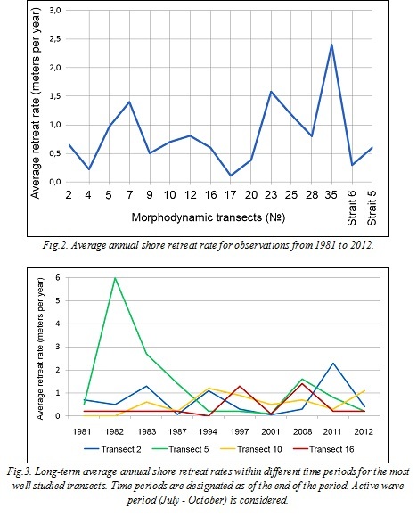
In general, sections of thermoabrasion and abrasion-thermodenudation coasts are developing under same morphogenetic processes that were observed there in 2011 and earlier. For example, the coast between southern tip of Karsky settlement and Nyavotalova-Yakha river mouth (morphogenetic transects 6-12) is developing under major influence of cryogenic landslide processes, with beach width among the lowest in the area (below 10m).
At accumulative coasts interannual relief changes are poorly visible. Topography alterations within beach can lead to visible changes in morphodynamic setting in case that they touch rivers and lakes. For example, in 2012 the Varkuyakha riverbed change was detected using instrumental monitoring: the river mouth shifted to the position 20-30 m north of the transect North 4, while in 2011 the mouth was situated south of this transect. Such change depicts major sediment transport along the shore from south to north between October 2011 and July 2012. Lagoon and estuary coasts are most variable among other accumulative types of coasts. Lagoon coasts of Sharapov Shar bay are not susceptible to rapid change due to low wave energy at the bay area. Direct human impact on coastal dynamics is represented by dredging works in the seaward part of the Sharapov Shar strait in 2011 and 2012, and by sand mining at the beaches near the mouth of Nyavotalova-Yakha river.
In general, long-term average annual shore retreat rate in the Kharasavey area is around 1 m per year, reaching 2 m per year at certain erosion-prone sections that usually feature bluffs composed of loams with high (45-50%) ice content. In certain years shore retreat rate increased considerably, which was caused by severe storms in the autumn or withdrawal of beach sediments for construction purposes. At the subaqueous coastal slope no major relief changes were detected since 2011.
Analysis of satellite images shows that average annual shore retreat rate at thermoabrasion and abrasion-thermodenudation coasts during the period from August 1964 to July 2006 ranges from 0.55 to 3.4 meters per year with average around 1.44 meters per year. Maximal retreat rates are observed at cape Kharasavey and 1-2 km north (Fig. 4), minimal - at thermodenudational northern coasts of Sharapov Shar strait in the east.
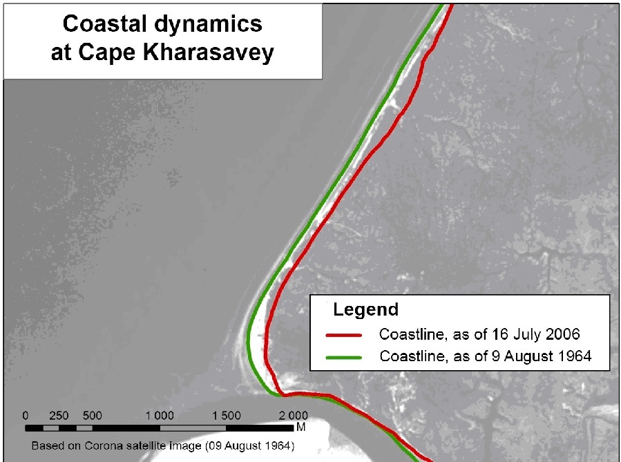
Fig. 4. Coastal dynamics nearby Cape Kharasavey
As the result of instrumental field measurements and remote sensing data analysis, the coast of Kara Sea at the Kharasavey key site was characterized for its geomorphologic and geological conditions and classified to various types for which different structure, composition, evolution and dynamics are attributed. The results are shown on the geomorphologic map of the area (Fig. 1). New data on the retreat of erosion coasts were analyzed along with evolution of shape of coasts at different morphodynamic transects. Dynamics of underwater coastal slope shape and sediment composition were studied. Spatial and temporal patterns of coastal evolution were observed.
V. Acknowledgment
The work was executed with the financial support of the Russian Science Foundation project No. 16-17-00034.
1. S.A. Ogorodov, “Criteria of stability of the Arctic coasts,” Natural and technical sciences, vol. 6, 2010, pp. 356-358 (in Russian).
2. S.A. Ogorodov, “The role of sea ice in the dynamics of the coastal zone of the Arctic seas,” Water resources, vol. 30, 5, 2003, pp. 555-564 (in Russian).
3. G.I. Dubikov, V.A. Sovershaev, V.S. Tuzhilkin, Natural conditions of the Baydaratskaya bay. Principal results of investigations for construction of underwater gas pipeline crossing (Yamal-Center mainline system), Moscow, GEOS, 1997, 432 p. (in Russian).
4. Yu.K. Vasil'chuk, G.V. Krylov, E.Ye. Podborny, Cryosphere of oil and gas condensate fields of Yamal peninsula. Vol. 1. Kharasavey gas condensate field, St.Petersburg, Nedra, 2006, 348 p. (in Russian).
5. I.V. Yuriev, “Problems of gas field exploitation in coastal zone of Western Yamal,” Earth Cryosphere, vol. XIII, 1, 2009, pp. 46-54 (in Russian).
6. N. G. Belova, V. I. Solomatin, H. Meyer, “Isotopic composition of massive ground ice exposure at the Kharasavey coast, West Yamal,” in Thermal state of frozen ground in a changing climate during the IPY: Abstracts of the Third Europ. Conf. on Permafrost (EUCOP III, 13-17 June), Univ. Centre in Svalbard, 2010, pp. 284-284.
7. A.B. Popov, V.A. Sovershaev, V.N. Novikov, V.Yu. Biryukov, A.M. Kamalov, E.V. Fedorova, “Coastal zone of the seas of Pechora and Kara regions,” in Investigations on stability of geosystems of the North, Moscow, MSU, 1988, pp. 191-201 (in Russian).
8. A.M. Kamalov, S.A. Ogorodov, V.Yu. Birukov, G.D. Sovershaeva, A.S. Tsvetsinsky, V.V. Arkhipov, N.G. Belova, A.I. Noskov, V.I. Solomatin, “Coastal and seabed morpholithodynamics of the Baydaratskaya Bay at the route of gas pipeline crossing,” Earth Cryosphere, vol. X, 3, 2006, pp.3-14 (in Russian).
9. H. Lantuit, P.P. Overduin, N. Couture, F. Aré, D. Atkinson, J. Brown, G. Cherkashov, D. Drozdov, D.L. Forbes, A. Graves-Gaylord, M. Grigoriev, H.-W. Hubberten, J. Jordan, T. Jorgenson, R.S. Ødegård, S. Ogorodov, W. Pollard, V. Rachold, S. Sedenko, S. Solomon, F. Steenhuisen, I. Streletskaya, A. Vasiliev and S. Wetterich, “The Arctic Coastal Dynamics database: a new classification scheme and statistics on Arctic permafrost coastlines,” Estuaries and Coasts, 2012, 35:383-400.