


BISAC NAT010000 Ecology
BISAC NAT045050 Ecosystems & Habitats / Coastal Regions & Shorelines
BISAC NAT025000 Ecosystems & Habitats / Oceans & Seas
BISAC NAT045030 Ecosystems & Habitats / Polar Regions
BISAC SCI081000 Earth Sciences / Hydrology
BISAC SCI092000 Global Warming & Climate Change
BISAC SCI020000 Life Sciences / Ecology
BISAC SCI039000 Life Sciences / Marine Biology
BISAC SOC053000 Regional Studies
BISAC TEC060000 Marine & Naval
The sea coasts are especially exposed to the oil pollution harmful influence as they frequently suffer from oil spills relating to the tanker accidents, port and off-shore activities. The objective of the present research is to examine the rates of spilled fuel oil natural destruction on geographically different seacoasts and to evaluate their relationship with principal environmental factors such as climatic and hydrological conditions, coast exposure and geomorphology, sediment types, intensity of biogeochemical cycles. For this purpose, a number of contaminated sectors of the Atlantic coasts of France and Spain (areas of “Erika” and “Prestige” tanker accidents), the Strait of Kerch (“Volgoneft-139” tanker accident) and the Black Sea coast in Russia (area of Novorossiysk sea port) were studied. Long-term (from 6 to 15 years) field observations were carried out there. The oiled samples were analyzed with the use of thin layer and column chromatography, optical and gravimetric methods. The results show that in the course of time, the oil slicks demonstrate an exponential diminution in their size, number and in the ratio of labile hydrocarbons content to conservative asphaltic components content. The half-period of this diminution varies from less than 1 to 12 years, subject to the forms of fuel oil traces and geographical conditions. On the Strait of Kerch coast washed by shallow, slightly salted and highly bio-productive waters of the Sea of Azov the spilled fuel oil tends to disappear twice as rapidly as on French and Spanish coasts of the Atlantic Ocean. The joint examination of the observed rates of oil pollution natural destruction and the geographical conditions of studied sites shows that temperature and seawater salinity are the crucial environmental factors of self-cleaning process.
oil pollution, oil spill, petroleum components, self-cleaning, seacoast, tanker “Erika”, tanker “Prestige”, tanker “Volgoneft-139”, the Croisic peninsula, the Loire River estuary, Noirmoutier Island, Cape Finisterre, the Strait of Kerch, Novorossiysk sea port.
I. Introduction
The ecosystems of sea coasts frequently suffer from oil spills relating to the tanker accidents, port and off-shore activities. Large oil spills from the tanker “Erika” accident in the Bay of Biscay outside the French coast of Brittany in December 1999 and the tanker “Prestige” accident off the north-western coast of Spain in November 2002, as well as the "Deepwater Horizon" oil-drilling rig explosion in the Gulf of Mexico in April 2010, are the glaring examples. As a result of storm waves and surf action, tides, and wind onsets, the slicks migrate with alongshore currents and accumulate in the littoral zone, cover cliffs and tidal platforms, penetrate into coastal sediments, provoke smothering and intoxication of benthic and planktonic organisms. Therefore, the study of regularities of oil pollution natural destruction and the assessment of vulnerability and self-cleaning capacity of coastal zones situated in different geographical conditions are of high importance.
Comprehension of the role of different factors for the self-cleaning process makes it possible to identify and to map areas sensitive to oil pollution. This information may be used for the purposes of environmental monitoring and the ecological substantiation when choosing the directions and sites ecologically suitable for the oil industry and infrastructure development. The environmental sensitivity maps are necessary for rational organization of protection, cleaning and restoration operations in cases of accidental oil spills in order to concentrate the efforts on the highly vulnerable geo-systems and to minimize the intervention on the sites where the natural mechanisms of oil distraction are sufficiently effective.
The regularities of oil pollution natural destruction in the aquatic environment are considered in an extensive body of literature [1-6]. However most of available information is obtained in short-term field observations or in laboratory experiments, which conditions differ considerably from natural. Usually, such studies deal with individual labile hydrocarbons or light petroleum fractions. Though, there is few documented long-term observational data on the natural transformation of crude oil or heavy oil products as complex multicomponent blends containing not only light hydrocarbons but also heavy and biochemically conservative asphaltic components (resins and asphaltenes) which destruction could last many years.
The present paper examines the results of long-term field research jointly carried out by the geographers of the Southern Federal University (Russia) and the University of Nantes (France) on the oiled sea coasts. The objective of this research is to evaluate the rates of oil pollution natural destruction as well as their relationship with principal geographical factors such as climatic and hydrological conditions, coast exposure and geomorphology, sediment types, intensity of biogeochemical cycles.
II. Study areas
For this research several geographically different sites where chosen in Russia, France and Spain (fig. 1). In France, they included the coasts of the Croisic peninsula and the island of Noirmoutier polluted by fuel oil from the broken tanker “Erika” (December 1999) as well as the Loire River estuary contaminated in consequence of an accident at an oil refinery in Donges (March 2008). In Spain, the studied sector covered the north-western coast of Galicia polluted by fuel oil from the broken tanker “Prestige” (November 2002). In Russia, regular observations were carried out in the Strait of Kerch contaminated by fuel oil from the broken tanker “Volgoneft-139” (November 2007) and in the area of major petroleum seaport of Novorossiysk on the Black Sea coast. The duration of the observations ranged from 6 to 15 years.
The north-western coast of France was hardly polluted in December 1999 as a result of the oil tanker “Erika” accident in the Bay of Biscay at 65 km to the south from Cape Penmarch. The tanker transported 31 thousand tonnes of heavy fuel oil no 6; about 20 thousand tonnes were released into the sea. The coasts about 450 km long were oiled [7-9]. Later, in March 2008 the loss of vacuum in pipeline at the oil refinery in Donges (France) provoked the release of 500 tonnes of fuel oil IFO-380 into the Loire River Estuary. The spilled oil penetrated into the protected estuarial wetlands of international importance. A part of the pollutant was carried from the estuary by tidal and fluvial currents and spread to the south along the Atlantic coast for 170 km from the sight of the accident [10].
On the Galician coasts of Spain, a severe disaster happened in November 2002: the oil tanker “Prestige” with 77 thousand tons of heavy fuel oil no 6 aboard ran into a heavy storm and sank at 220 km to the south-west from Cape Finisterre. More than 60 thousand tons of the cargo were spilled. The oil pollution spread over coasts of Spain, Portugal and France 1200 km long [8, 11].
In the Strait of Kerch in November 2007 an extraordinary heavy storm caught tens of small-size river-marine vessels. Three dry cargo ships sank, two barges ran aground, the tanker “Volgoneft-123” was damaged, and the tanker “Volgoneft-139” split in half; about 1300 tonnes of heavy fuel oil no. 6 were released. About 50 linear kilometers of coasts, as well as the shallow Taman Bay and the Sea of Azov, were contaminated [12-16].
The city of Novorossiysk is the most important seaport of Russia on the Black Sea coast. Russian sector of the Black Sea is situated in the intersection of important directions of crude oil and oil products transportation. About 20% of Russian oil export and the most of Kazakh oil export totaling more than 100 million tons annually pass through Russian Black Sea ports including over 90 million tons of crude oil and products of its distillation shipped from oil terminals of Novorossiysk [17]. This factor surely generates high anthropogenic impact on the picturesque subtropical landscapes and recreational infrastructure of the Black Sea coast.
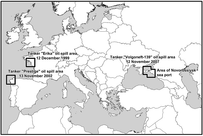
Fig. 1. Areas of oil pollution natural transformation monitoring.
III. Materials and methods
In the north-west of France, the field observations were focused on the coasts of the Croisic peninsula and the Noirmoutier island hardly polluted by fuel oil from the tanker “Erika” (December 1999), as well as on the Loire River estuary contaminated in consequence of an accident at the oil refinery in Donges (March 2008). In 1999-2000, during the cleanup operations, a comparative study of impacts relating to the cleanup of the oiled coasts had been realized [18]. Since then, seven expeditions were organized: in December 2004, November 2006, October 2007, November 2008, November 2009, November 2012, and November 2014. In the Loire River estuary, the first sampling of spilled oil was performed in April 2008, one month after the accident. After that, four expeditions were carried out: in November 2008, November 2009, November 2012, and November 2014. The Galician coasts of Spain polluted by fuel oil from the tanker “Prestige” (November 2002) were studied in October 2012 and November 2014. Special attention was paid to the Cape Finisterre. On the Black Sea coast in the area of Novorossiysk the observations were started in August 2007. In the Strait of Kerch, for the first time they were performed in December 2007, 40 days after the “Volgoneft-139” oil spill. Since then, eight expeditions were carried out both in the Strait of Kerch and on the Black Sea coast: in August 2008, September 2009, August 2010, January and August 2011, June 2012, June 2013 and September 2014. The Tuzla dam and the Tchushka spit were studied in detail.
The program of the research included visual assessment, description and sampling of oil slicks and sediment cores as well as hydrometeorological observations. The sediment core layers were dated due to the measurement of 137Cs, 210Pb and 226Ra specific activities. In total on the French and Spanish coasts of the Bay of Biscay and in the Loire River estuary 110 samples of oil slicks and 24 sediment cores up to 30 cm thick divided into 70 samples were taken. In the Strait of Kerch 115 oil slicks and 20 sediment cores up to 50 cm thick divided into 86 layers were sampled. On the Russian Black Sea coast in the area of Novorossiysk 95 samples of oil slicks and 4 sediment cores up to 20 cm thick divided into 22 samples were taken.
The samples were analyzed in the laboratory of Hydrochemical institute of Russian Federal Service for Hydrometeorology and Environmental Monitoring with the use of the attested complex of methods including the thin layer chromatography, infrared and ultraviolet spectrophotometry, luminescent and gravimetric methods [19]. These methods made it possible to determine separately the mass concentrations of three groups of petroleum components: 1) the aliphatic, naphthenic, mono- and di-aromatic hydrocarbons (HC); 2) the polycyclic aromatic hydrocarbons (PAH); 3) the asphaltic components (AC) including the resins and the asphaltenes. The presence of hydrocarbons of contemporary biological origin was also identified.
IV. Results and discussion
The results of long-term field observations show that even 15 years after the tanker “Erika” accident, 12 years after the tanker “Prestige” accident and 7 years after the shipwrecks in the Strait of Kerch the traces of spilled fuel oil were still present on the contaminated coasts, although their number and size had decreased considerably due to self-cleaning process. The forms of these traces varied from dried stains and drips strongly adherent to the rocky substrate to weathered crusts up to several centimeters thick and even large slightly weathered accumulations in the fissures of rocks. The essential quantity of fuel oil slicks was found in the upper and middle parts of littoral zone where they initially had more time to adhere to the substrate and to dry up due to low impact of tides and surf action.
The comparative analysis of temporal changes in the chemical composition of fuel oil traces makes it possible to reveal some important regularities. Particularly it is concluded that the asphaltic components (resins and asphaltenes) being always present in crude oil and heavy products of its distillation are the most stable indicators of oil pollution. These viscous and biochemically conservative substances strongly adhere to rocky substrate and actively accumulate in sediments where their natural destruction may last for many years. In contrast to hydrocarbons, the asphaltic petroleum components can be distinguished from the similar substances of contemporary biological origin due to their ability to luminesce in different spectral zones.
In the course of time, the oil slicks demonstrate a steady decrease in the percentage of relatively labile aliphatic, naphthenic, mono- and di-aromatic hydrocarbons due to their natural destruction. At the same time, the residual percentage of conservative asphaltic components (resins and asphaltenes) rises (from 20-25% in the initial fuel oil up to 33-45% in the first two years and up to 73-95% in 10 years). Therefore, in our previous publications [14, 15, 20, 21] we suggested and substantiated that the ratio of the labile hydrocarbons content to the conservative asphaltic components content (HC/AC) may be considered as a simplified indicator of the oil pollution transformation level. Hence, the rate of diminution of this ratio may be used to quantify the self-cleaning process dynamics. Moreover, we claim that the ratio HC/AC is more suitable for this purpose than the mass concentrations for the reason that it takes into account the change in the pollutant composition only and is not considerably influenced by dilution, migration and other mechanical factors.
The exponential curve of the HC/AC ratio diminution (fig. 2) makes it possible to approximate the process by the first order kinetic equation:
|
(HC/AC)t = (HC/AC)0 ∙ e-kt, |
(1) |
where (HC/AC)0 and (HC/AC)t are the ratios of hydrocarbons content to asphaltic components content respectively in the initial moment and after the expiration of the temporal interval t, and k is the kinetic constant equal to the proportion of the pollutant transformed in a day (if t is expressed in days). This constant may be converted to the half-period of oil pollution transformation (T) using the equation: T = ln2/k. In the studied cases the values of half-period of oil pollution natural transformation ranged from 207 to 4367 days, subject to the forms of pollutant traces and environmental conditions (fig. 2, tab.).
In the similar geographical conditions, the rates of oil pollution natural transformation depend mainly on the pollutant dispersity being the factor of the contact surface with water, fresh air and substrate. Thin films adherent to the rocky substrate in the upper part of the littoral zone and exposed to the regular influence of fresh air, solar radiation, sea water, and surf action are being destructed at the highest rates.
The results of regression analysis of the set of data on 162 samples of oil slicks taken on the Russian, French and Spanish coasts show that the half-period of a fuel oil slick transformation (T) significantly (r = 0,86) depends on its thickness (h, mm) according to the equation:
|
Ti = T1 ∙ h0.408 |
(2) |
where Ti is the half-period of transformation of an oil slick i mm thick and T1 is the half-period of transformation of an oil slick one mm thick. The exponent of h is statistically significant (p-value is much less than 0.05, standard error is 0.010).
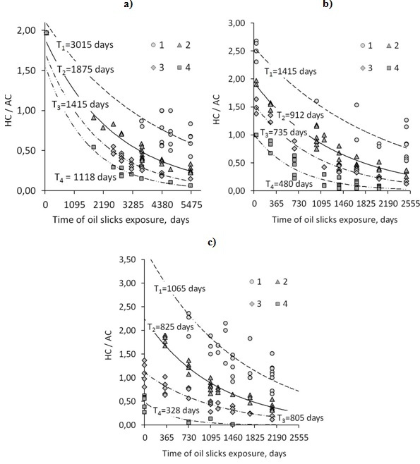
Fig. 2. Temporal changes in the ratio of hydrocarbons content to asphaltic components content (HC/AC) in the fuel oil slicks found on the Atlantic coasts of France and Spain (a), in the Strait of Kerch (b) and on the Black Sea coast in the area of Novorossiysk (c): 1 - large accumulations of fuel oil with weathered superficial crusts; 2 - weathered crusts of fuel oil 2 to 5 cm thick; 3 - weathered crusts of fuel oil 5 to 10 cm thick; 4 - weathered films of fuel oil; T – average half-periods of oil pollution natural transformation (the indexes correspond to the numbers in the legend).
Table. Half-periods of fuel oil natural transformation on the sea coasts situated in different geographical conditions
|
Polluted site |
Part of littoral zone |
Forms of fuel oil traces |
|||
|
Films |
Crusts 2 to 5 mm thick |
Crusts 5 to 10 mm thick |
Large accumulations |
||
|
Western coast of France, Croisic Peninsula and Noirmoutier Island, large granitic tidal flat passing into low granitic cliffs and dunes |
upper |
1073 (5) |
1368 (7) |
1910 (6) |
3309 (7) |
|
middle |
1137 (4) |
1440 (7) |
1898 (7) |
2739 (4) |
|
|
Loire River estuary, muddy coast with reeds and protection embankment |
upper |
426 (4) |
759 (2) |
891 (2) |
- |
|
middle |
- |
838 (2) |
- |
- |
|
|
North-Western coast of Spain, Cape Finisterre, high granitic cliffs surrounding a bay with sand beach and dune |
above high tide level |
- |
- |
1961 (2) |
2598 (1) |
|
upper |
- |
1421 (3) |
1901 (2) |
3187 (3) |
|
|
middle |
- |
1428 (2) |
1670 (6) |
3178 (4) |
|
|
Strait of Kerch, the Black Sea side, Tuzla dam made of limestone blocks with narrow sand beaches |
upper |
440 (3) |
733 (2) |
896 (4) |
1374 (2) |
|
middle |
659 (14) |
834 (7) |
896 (9) |
2198 (5) |
|
|
lower |
612 (2) |
782 (5) |
1016 (3) |
1534 (1) |
|
|
Strait of Kerch, the Sea of Azov side, low clay cliff with protection embankment, large sand beach, rock groynes |
upper |
504 (5) |
- |
961 (7) |
- |
|
middle |
551 (3) |
723 (2) |
- |
1103 (1) |
|
|
lower |
567 (4) |
739 (2) |
944 (6) |
1199 (3) |
|
|
Area of Novorossiysk seaport, the Black Sea coast, high flysh cliffs with pebbly and gravel beaches and spits |
upper |
- |
- |
899 (5) |
707 (1) |
|
middle |
291 (2) |
846 (20) |
821 (20) |
1151 (26) |
|
|
lower |
259 (3) |
- |
794 (4) |
990 (3) |
|
* The numbers in the parentheses are the numbers of samples.
If we consider the influence of geographical conditions on the rates of oil pollution natural transformation, we can conclude that the inflow of solar energy, the thermal conditions and the sea water salinity are the main factors. In the Strait of Kerch and on the Black Sea coast where the annual number of solar days and the annual sum of biologically active temperatures are the highest in the range of the studied sites while the sea water salinity is the lowest, the self-cleaning process is approximately twice more active than on the Atlantic coasts of France and Spain (fig. 3, tab.).
IV. Conclusion
To recapitulate, the results of long-term field research show that even up to 15 years after the fuel oil spills their weathered traces were still present in the coastal zone, especially in its upper part where they initially had more time to adhere to the rocks and to dry up due to low impact of tides and surf action. However, the size and quantity of these traces have reduced considerably. In the course of time the oil slicks found on the coastal rocks demonstrated an exponential diminution in the ratio of labile hydrocarbons content to conservative asphaltic components content (HC/AC). In the studied cases, the half-periods of this diminution varied from 207 to 4367 days characterising the activity of self-cleaning process.
The highest rates of self-cleaning were usually detected for small fuel oil traces exposed to the influence of fresh air, solar radiation, storm waves, and surf action. On the Strait of Kerch coast influenced by shallow, slightly salted and highly bio-productive waters of the Sea of Azov the spilled fuel oil tended to disappear twice more rapidly than on French and Spanish coasts washed by the Atlantic Ocean. The joint examination of the observed rates of oil pollution natural destruction and the geographical conditions of studied sites shows that temperature and seawater salinity are the crucial factors for the self-cleaning process. It should be said that previously a great number of researchers have already recognized high importance of thermal conditions for the spilled oil natural destruction. However, till now the role of water salinity was underestimated.
V. Acknowledgment
The study was supported by the Ministry of Education and Science of the Russian Federation (project no. 5.1848.2014/K).
1. A. Nelson-Smith, “Oil Pollution and Marine Ecology”. London: Elek Science, 1972.
2. “Oil in the sea. Inputs, fates and effects”. Washington: US National Research Council, 1985.
3. L. Paalme, N. Irha, E. Urbas, A. Tsyban, U. Kirso, “Model studies of photochemical oxidation of carcinogenic polyaromatic hydrocarbons”, Marine Chemistry, vol. 30, iss. C, pp. 105-111, 1990.
4. “Impact of Oil and Related Chemicals on the Marine Environment”. London: GESAMP, 1993.
5. “Estimates of Oil Entering the Marine Environment from Sea-Based Activities”, Reports and Studies, no 75. London: GESAMP, 2007.
6. I.A. Nemirovskaya, L.M. Gurvich, “Transformation of oil pollution in the marine environment”, Environment Canada Arctic and Marine Oil Spill Program Technical Seminar (AMOP) Proceedings, vol. 21, iss. 2, pp. 923-936, June 1998.
7. C. Tiercelin, M. Marchand, C. Rousseau, “Accident de l’Erika, Golfe de Gascogne (Sud-Bretagne)”, Bulletin d'Information du CEDRE, no 13, pp. 10-19, December 1999.
8. P. Fattal, “Pollution des côtes par les hydrocarbures”. Rennes: Press Universitaire de Renne, 2008.
9. P. Fattal, M. Maanan, I. Tillier, N. Rollo, M. Robin, P. Pottier, “Coastal Vulnerability to Oil Spill Pollution: The Case of Noirmoutier Island (France)”, Journal of Coastal Research, 26 (5), pp. 879-887, September 2010.
10. F. Poncet, “Raffinerie de Donges: Fuite sur une Canalisation“, Bulletin d’Information du CEDRE, no 25, pp. 4-11, June 2009.
11. C. Rousseau, M. Girin, “Accident du Prestige: le Volet Français”, Bulletin d'Information du CEDRE, no 19, pp. 4-16, May 2004.
12. “Accident of Kerch: Consequences for the Water Ecosystems”. Rostov-on-Don: Azov Fishery Research Institute, 2008.
13. “Assessment of the Strait of Kerch and Surrounding Seas Environment Pollution Resulting from the Accidental Oil Spill on the 11 November 2007 Using the Data of Mathematical Modeling, Regular Monitoring and Episodic Observations”. Moscow: Russian State Oceanographic Institute, 2009.
14. A.N. Kuznetsov, Yu.A. Fedorov, P. Fattal, “Impacts of the 2007 Kertch Oil Spill”, Mediterranee, no 119, iss. 2, pp. 91-99, April 2013.
15. A.N. Kuznetsov, Yu.A. Fedorov, P. Fattal, K.A. Zagranichny, “Peculiarities of Fuel Oil Natural Transformation in the Strait of Kerch Polluted in November 2007 in Consequence of Tanker Accident”, Proceedings of the 13th International Multidisciplinary Scientific GeoConference SGEM 2013, vol. 3. Sofia: STEF92 Technology Ltd., pp. 839-846, June 2013.
16. G.G. Matishov, Yu.I. Inzhebeikin, R.M. Savitskii, “The Environmental and Biotic Impact of the Oil Spill in Kerch Strait in November 2007”, Water Resources, vol. 40, no 3, pp. 271-284, June 2013.
17. A.N. Kuznetsov, Yu.A. Fedorov, P. Fattal, “Oil Pollution of the Black Sea Coastal Zone in the Area of Oil Terminals of Novorossiysk”, Proceedings of the 15th International Multidisciplinary Scientific GeoConference SGEM 2015, vol. 3. Sofia: STEF92 Technology Ltd., pp. 683-690, June 2015.
18. P. Fattal, B. Fichaut, “Erika: A first assessment of the impact of the cleaning techniques on the coastal morphology”, Annales de Geographie, iss. 623, pp. 3-24, June 2002.
19. A.M. Nikanorov, A.G. Stradomskaya, “Identification of Petroleum Pollution Sources of Water Bodies and Streams”, Water Resources, vol. 36, no 2, pp. 163-169, April 2009.
20. Y.A. Fedorov, A.G. Stradomskaya, A.N. Kuznetsov, “Regularities in the Transformation of Oil Pollution in Watercourses Based on Long-Term Observational Data”, Water Resources, vol. 33, no. 3, pp. 300-309, May 2006.
21. A.N. Kuznetsov, Yu.A. Fedorov, P. Fattal, “Regularities of spilled oil transformation in watercourses and coastal zone (results of long-term observations)”, Proceedings of the 11th International Multidisciplinary Scientific GeoConference SGEM 2013, vol. 3. Sofia: STEF92 Technology Ltd., pp. 579-586, June 2011.